Weather
Severe MD Storms Threaten Afternoon Commute: See Latest Timeline
A severe thunderstorm watch covers the majority of Maryland through 9 p.m., with the height of the storm to impact the afternoon commute.


Updated at 6:42 p.m.
A severe thunderstorm watch is in effect Monday for most of Maryland, as storms capable of producing hazardous conditions are forecast across the region.
The National Weather Service issued the severe thunderstorm watch through at least 9 p.m.
Find out what's happening in Across Marylandfor free with the latest updates from Patch.
It encompasses 15 jurisdictions, including Harford, Prince George's, Anne Arundel, Howard, Baltimore and Montgomery counties. Baltimore City is also among the impacted areas.
A severe thunderstorm warning was issued for portions of Anne Arundel, Howard, Montgomery and Prince George's counties, as the NWS also issued a tornado warning for parts of Anne Arundel, Baltimore and Howard counties.
Find out what's happening in Across Marylandfor free with the latest updates from Patch.
"This is a destructive storm for northern Howard and southwestern Baltimore counties," read an earlier advisory from the NWS. "Your life is at significant risk if outdoors."
A flash flood warning remains in effect until 8:45 p.m. for parts of Baltimore City and Harford and Baltimore counties.
Timeline For Storms
NWS forecasts indicate severe storms will likely begin to impact the region after 4 p.m., with the greatest threat of the storm potentially sticking around through 8 p.m.
Anywhere between a tenth to a quarter of an inch of rain could fall across the state. Officials warn that isolated rainfall totals could be much higher during the storm.
.png)
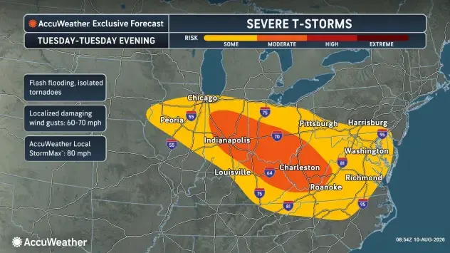
In addition to the downpour, possibility of flooded roadways and impacts to nearby waterways, the latest storm cells have the potential to bring damaging wind gusts from about 60 to 70 mph.
Also forecast are lightning and hail, as well as the possibility for a tornado.
Marylanders are urged to be cautious while outdoors and take necessary precautions in the event of power outages or downed trees.
Next Chance For Storms?
A seven-day outlook suggests Monday won't be the only day that residents will have to pack an umbrella or be mindful of possible storm alerts.
Similar to last week, the latest forecast shows showers and thunderstorms are likely every day this week, with the highest chance on Tuesday and Wednesday night.
Storm chances are between 20 and 30 percent Thursday through Sunday.
Detailed Forecast For Baltimore Region
Monday Afternoon: Showers and thunderstorms likely, mainly after 4 p.m. Some of the storms could be severe. Partly sunny, with a high near 93. West wind around 7 mph. Chance of precipitation is 60%. New rainfall amounts between a tenth and quarter of an inch, except higher amounts possible in thunderstorms.
Monday Night: Showers and thunderstorms likely, mainly before 10 p.m. Some of the storms could be severe. Mostly cloudy, with a low around 73. West wind 3 to 6 mph. Chance of precipitation is 60%. New precipitation amounts of less than a tenth of an inch, except higher amounts possible in thunderstorms.
Tuesday: A chance of showers and thunderstorms between 2 p.m. and 5 p.m., then showers likely and possibly a thunderstorm after 5 p.m. Mostly sunny, with a high near 90. West wind 3 to 8 mph. Chance of precipitation is 60%. New rainfall amounts between a tenth and quarter of an inch, except higher amounts possible in thunderstorms.
Tuesday Night: Showers and thunderstorms likely before 2 a.m., then a chance of showers. Mostly cloudy, with a low around 70. Southwest wind 3 to 5 mph. Chance of precipitation is 70%. New rainfall amounts between a tenth and quarter of an inch, except higher amounts possible in thunderstorms.
Wednesday: A slight chance of showers and thunderstorms after 2 p.m. Mostly sunny, with a high near 87. Northwest wind around 5 mph. Chance of precipitation is 20%.
Wednesday Night: A chance of showers and thunderstorms. Mostly cloudy, with a low around 70. Chance of precipitation is 40%.
Thursday: A slight chance of showers, with thunderstorms also possible after 2 p.m. Mostly sunny, with a high near 89. Chance of precipitation is 20%.
Thursday Night: A chance of showers and thunderstorms before 2 a.m., then a slight chance of showers. Mostly cloudy, with a low around 72. Chance of precipitation is 30%.
Friday: A chance of showers, with thunderstorms also possible after 2 p.m. Partly sunny, with a high near 87. Chance of precipitation is 30%.
Friday Night: Partly cloudy, with a low around 66.
Saturday: Mostly sunny, with a high near 83.
Saturday Night: A slight chance of showers and thunderstorms. Partly cloudy, with a low around 68. Chance of precipitation is 20%.
Sunday: A chance of showers and thunderstorms. Partly sunny, with a high near 86. Chance of precipitation is 30%.
Get more local news delivered straight to your inbox. Sign up for free Patch newsletters and alerts.