Weather
Big Weather Shift Coming To Maryland: See New Forecast
Snow, rain, ice, tornadoes, heat, cold — it's all hit Maryland in the past few weeks, and stability is not on the immediate radar.

Seasons seem less distinct in the Baltimore region these days, with hints of just about every type of major weather pattern hitting the area over the past several weeks, including two tornadoes on Monday.
The next dramatic shift up: spring and summer-like sun, forecasters said.
Maryland is likely to see a continued warming trend this weekend as a clipper system moves into the state, according to the National Weather Service.
Find out what's happening in Baltimorefor free with the latest updates from Patch.
In the Baltimore region, highs will approach 68 degrees on Friday, 62 on Saturday and will exceed 70 degrees by Sunday. Cooler numbers could be possible in northeast Maryland and along the Chesapeake Bay.
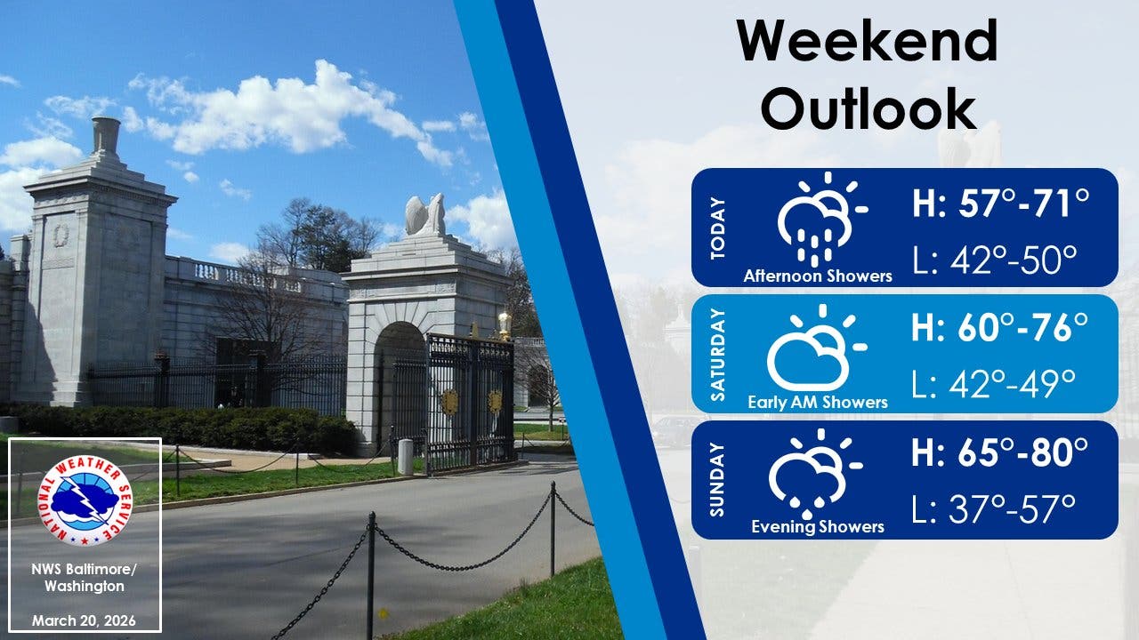
Some rainfall is possible this weekend in two main bursts. Rain showers and a few thunderstorms are possible Friday afternoon into Saturday morning as a cold front drops through. Conditions are expected to dry out Saturday and Sunday ahead of another front, which brings rain chances Sunday evening and into the overnight hours.
Find out what's happening in Baltimorefor free with the latest updates from Patch.
Related: 2 MD Tornadoes Confirmed During Monday Storms
Early next week, another shift in the jet stream will allow a fresh surge of colder air to spill into Maryland, according to a recent AccuWeather forecast.
Temperatures in the Baltimore region will drop to around 50 degrees by Tuesday and remain in the 50s until later in the week.
Looking ahead, Marylanders should expect additional back-and-forth swings between warm and chilly air into April, AccuWeather predicts.
"Do not pack your winter coat away yet. The late-March pattern remains highly volatile, with more swings between warm and cold ahead," AccuWeather senior meteorologist Tyler Roys said.
Here's a look at the detailed forecast for the Baltimore region:
Friday: Partly sunny, with a high near 68. South wind 13 to 15 mph, with gusts as high as 24 mph.
Friday Night: Showers likely, mainly before 11pm. Cloudy, then gradually becoming partly cloudy, with a low around 49. Southwest wind 6 to 11 mph, with gusts as high as 21 mph. Chance of precipitation is 60%. New precipitation amounts between a tenth and quarter of an inch possible.
Saturday: Mostly sunny, with a high near 62. North wind around 7 mph.
Saturday Night: Mostly cloudy, with a low around 45. Light and variable wind.
Sunday: Partly sunny, with a high near 73. South wind 5 to 9 mph.
Sunday Night: A chance of rain, mainly after 2am. Mostly cloudy, with a low around 52. Chance of precipitation is 50%.
Monday: A chance of rain before 2pm. Partly sunny, with a high near 60. Chance of precipitation is 40%.
Monday Night: Mostly clear, with a low around 32.
Tuesday: Sunny, with a high near 51.
Get more local news delivered straight to your inbox. Sign up for free Patch newsletters and alerts.