Weather
Hurricane Dorian Maryland: Storm Racing Away, OC Under Advisory
The National Weather Service said Ocean City remains under a coastal flood advisory as Hurricane Dorian moves away from Maryland.

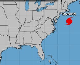
MARYLAND — Hurricane Dorian is racing away from the mid-Atlantic after bringing rain and rough surf to southern Maryland and the Eastern Shore, but the National Weather Service cautioned that flooding and hazardous beach conditions remain concerns Saturday. Before spinning to the northeast the hurricane trapped an estimated 800 residents of Ocracoke Island, North Carolina, in their homes, and chased beach-goers away from the shore at Ocean City. At 5:22 p.m. Friday, the hurricane was about 250 miles east-southeast of Annapolis with sustained winds of 90 miles per hour. By 11 p.m., it was 200 miles south of Nantucket, Massachusetts, heading northeast at 25 mph with 90 mph winds.
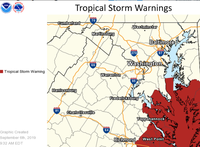
The tropical storm warning south of Fenwick Island, Delaware, and for the Chesapeake Bay from Drum Point southward have been discontinued, the weather service said in its 8 p.m. update Friday. A tropical storm warning was later discontinued for Ocean City.
Storm surge flooding of more than 1 foot above ground remains a threat, the National Weather Service said. A coastal flood advisory is in effect until 10 a.m. Saturday, while rip currents will be dangerous through Saturday night in Ocean City.
Find out what's happening in Baltimorefor free with the latest updates from Patch.
Unlike North Carolina, which was hit by 20 tornadoes on Thursday, the odds of a tornado developing on the Eastern Shore were slim, forecasters said.
Dorian is now headed toward Massachusetts and then the Canadian maritime provinces, the National Hurricane Center said at 5 p.m. Friday. It will move southeast of southern New England Friday night and Saturday, and then pass over Nova Scotia Saturday or Saturday night. A continued northeastward motion is then expected to bring the cyclone across Newfoundland into the far north Atlantic.
Find out what's happening in Baltimorefor free with the latest updates from Patch.
The hurricane made landfall in North Carolina with maximum sustained winds of 90 mph and may have brought up to seven feet of water to the land, according to the National Weather Service. Facebook user Harris Kelton Williams Jr. posted a video of his Suburban floating away, taken by the powerful waters on Ocracoke Island. "I will admit I was a little scared when I saw my suburban float away," he posted.
St. Mary's County: Minor Flooding A Threat
All watches and warnings for St. Mary's County were canceled shortly after 5 p.m. Friday by the National Weather Service. "Wind impacts have come to an end for St. Mary's County. Tidal flooding is not expected through tonight, but water levels may rise sharply Saturday and Saturday night. This may cause moderate flooding along portions of the western shore of the Chesapeake Bay and Tidal Potomac River," according to the updated forecast.
Residents were warned to look for water over roads.
"Inundation is occurring at multiple marinas off Saint Mary's River, Smith Creek and Jutland Creek," the National Weather Service reported at 3:15 p.m. Friday. "At 3.5 feet, water covers roads on Saint George Island, is in yards, and is approaching structures."
A coastal flood watch remains in effect from 6 a.m. Saturday through late Saturday night for St. Mary's County, where officials said water levels may rise sharply.
Up to one foot of inundation above ground level is possible. At 3.5 feet, water covers roads on Saint George Island, is in yards, and is approaching structures. To the east, inundation is occurring at multiple marinas off St. Mary's River, Smith Creek, and Jutland Creek.
SEE ALSO: Hurricane Dorian: Assateague Island's Wild Horses Brave The Storm
Tropical Storm Warning, Coastal Flood Advisory For Maryland Beaches
Ocean City and Maryland beaches are no longer under a tropical storm warning.
The potential for moderate to locally major flooding at Maryland beaches prompted the National Weather Service to issue a coastal flood advisory, effective until 10 a.m. Saturday. Up to 1 foot of water may come onshore in low-lying areas near tidal waterways and shorelines, according to the advisory. Some roads, parking lots, parks and lawns near the water may have shallow flooding. People should not drive through standing water.
Some road closures were already in effect by 3 p.m. Friday in Ocean City.
Citing serious concerns over strong surf and limited visibility, the Ocean City Beach Patrol restricted swimming Friday and said surf conditions may be affected through the weekend.
Breaking waves of 5 to 10 feet on the ocean side of Worcester County, which contains Ocean City, will make for rough surf, and there is a high risk of rip currents, according to the coastal flood advisory.
Winds are expected to peak at 25 to 35 mph with gusts up to 50 mph. People should move to a safe area before the strong winds strike. Residents should batten down their outdoor furniture, including grills, and ensure their boats are secured, Ocean City officials said.
Limited impacts are anticipated, with trees uprooted, road signs potentially damaged and damage to porches, awnings, sheds, carports and mobile homes that are not anchored.
Bridges and other elevated roads are expected to be especially hazardous, and some roads may become impassable due to debris. Scattered power outages are possible.
Storm surge may bring 1 to 3 feet of water above ground through Saturday afternoon. People should stay away from surge-prone areas.
"Potential impacts from the main surge event are also now unfolding across...communities near the Chesapeake Bay," the National Weather Service reported before noon. "Remain well away from locally hazardous surge."
Additionally, the weather service warned: "Do not be a thrill seeker or risk your life for senseless photos or videos."
About 1 inch of rain is expected, which may lead to flooding, according to the warning. Flooding is likely to be moderate, but the impacts may be significant.
"Flooding from heavy rainfall may prompt evacuations and rescues," officials warned of Ocean City. "Some road and bridge closures are expected."
How To Prepare For Tropical Storm Conditions
- Keep cell phones charged and in power-saving mode.
- Stay inside and away from windows.
- Keep rain gear handy and shoes on; boots or athletic shoes protect best from the elements in this case.
- Plan for extra travel time since some roads may flood and be temporarily closed.
- Turn around — don't drown — if you come across a water-covered road. Just a few inches of water can cause a vehicle to move.
- Treat all intersections where power is out as a two or four-way stop, and use headlights if windshield wipers are on.
- Gather emergency supplies.
- Move unsecured objects inside or anchor them.
- Leave low-lying vulnerable areas before conditions become unsafe. Leave immediately if evacuation orders are given for your area. Know your evacuation zone. This is the evacuation map for Ocean City.
Traveling to the Eastern Shore Friday afternoon and evening?
Here's what the Maryland Emergency Management Agency advised:
- Tropical storm-force winds are possible.
- Regional flooding is possible.
- DO NOT drive through flooded roadways.
- Beware of dangerous rip currents.
SEE ALSO:
Get more local news delivered straight to your inbox. Sign up for free Patch newsletters and alerts.