Weather
Maryland Weather: Severe Thunderstorms And Daily Rain In Forecast
Strong winds and large hail are possible Monday across Maryland, weather officials advise, plus more chances of storms are in the forecast.


BALTIMORE, MD — A stormy week of weather lies ahead for Maryland, according to forecasters. Severe thunderstorms, isolated showers and possible flooding are in the forecast.
The National Weather Service issued a severe thunderstorm watch on Monday afternoon, and the forecast is looking rainy all week long.
The severe thunderstorm watch is in effect until 9 p.m. on Monday, May 14. During the watch period, scattered severe thunderstorms with damaging wind gusts and large hail are possible, according to the National Weather Service.
Find out what's happening in Baltimorefor free with the latest updates from Patch.
The greatest risk of severe thunderstorms Monday is south of US 50, weather officials said.
In addition to Baltimore City, the following counties are included in the severe thunderstorm watch:
Find out what's happening in Baltimorefor free with the latest updates from Patch.
- Allegany
- Anne Arundel
- Baltimore
- Calvert
- Carroll
- Charles
- Frederick
- Garrett
- Harford
- Howard
- Montgomery
- Prince George's
- St. Mary's
- Washington
A severe thunderstorm watch means there is potential for severe thunderstorms. It usually precedes a severe thunderstorm warning, which weather officials issue if a storm has developed and will strike soon.
The National Weather Service offers these tips for staying safe during a severe thunderstorm:
- Stay inside a sturdy building, and bring your pets in too.
- Secure loose objects outside if possible.
- Avoid open spaces, high ground and metallic objects.
- Get out of boats and away from bodies of water.
- Postpone outdoor activities until the storms have passed.
A severe thunderstorm watch has been issued for parts of DC, MD, OH, PA, VA, WV until 9 PM EDT pic.twitter.com/9HUIVvCWAt
— NWS DC/Baltimore (@NWS_BaltWash) May 14, 2018
A new weather pattern is going to bring showers and thunderstorms to the mid-Atlantic on a "nearly daily basis this week," AccuWeather predicts.
"After a relatively warm and dry start to the month of May, the pattern has become much more humid and wet..." AccuWeather Senior Meteorologist Dan Pydynowski said in a statement. "Moisture flowing northward into the area combined with a stalled front will yield the unsettled weather in places such as Washington, D.C., Baltimore and Philadelphia through much of the week."
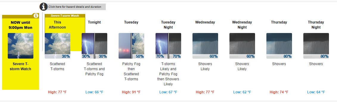
Here's the preliminary forecast for central Maryland, from the National Weather Service:
The National Weather Service issued a hazardous weather outlook for much of the state, noting that Monday afternoon and evening, Tuesday afternoon and evening, Thursday night and Friday may bring severe weather.
Monday: Scattered showers mainly after 5 p.m. Severe thunderstorm watch until 9 p.m. High: 77, low: 66.
Tuesday: Showers likely before 8 a.m. and after 2 p.m. Strong winds and hail possible in the afternoon and evening. High of 91 and low of 67 degrees.
Wednesday: Showers likely, with a high of 77 and low of 62 degrees.
Thursday: Showers likely. Flooding of small streams and urban areas is a possibility at night. High of 74 and low of 64 degrees.
Friday: Flooding of small streams and urban areas possible. High of 72 degrees.
With reporting from Patch editors Kara Seymour, Tom Davis and Dan Taylor.
Photo by Elizabeth Janney. Graphic via National Weather Service.
Get more local news delivered straight to your inbox. Sign up for free Patch newsletters and alerts.