Weather
Flash Flood Warning Expires In Northern Harford County
Before 7:15 p.m., the National Weather Service reported the flood threat was over in Harford.


HARFORD COUNTY, MD — The flash flood warning has expired for Harford County, the National Weather Service reported before 7:15 p.m.
A flash flood watch remains in effect until 11 p.m. Wednesday. Weather officials advise there is a higher-than-usual risk of flash flooding.
Those in low-lying areas should be prepared to move to higher ground, and drivers should be extra cautious at night.
Find out what's happening in Bel Airfor free with the latest updates from Patch.
The Flash Flood Warning for northern Harford county is cancelled. The heavy rain has ended. Flooding is no longer expected to pose a threat. Please continue to heed any remaining road closures.#MDwx pic.twitter.com/FlJcLe84JD
— Maryland Weather (@stateMDWX) August 12, 2020
Slow-moving thunderstorms will continue to move throughout the region Wednesday night and may create localized areas of heavy rain.
Structures in low-lying areas near streams may flood, and landslides and sinkholes are possible, according to the flash flood watch from the National Weather Service.
Find out what's happening in Bel Airfor free with the latest updates from Patch.
Forecasters say thunderstorms are possible Thursday as well.
PREVIOUS REPORT (EXPIRED): Authorities are warning people in northern Harford County that flash flooding is occurring or is about to occur Wednesday night after heavy rain fell atop already saturated areas. Flash flooding, or a rapid rise in water level, is a life-threatening situation, and people should not drive into floodwaters or attempt to walk through flooded roads.
A flash flood warning is in effect until 8:30 p.m. Wednesday for northern Harford County.
More than 2 inches of rain had fallen by 5:30 p.m. Wednesday near Norrisville and Pylesville, the National Weather Service reported, citing radar and automated gauges.
See Also: Lightning Strike Sparks Mt. Felix Barn Fire Near Havre de Grace
Creeks, streams, highways, streets and underpasses are areas where flooding may occur.
These places in particular may flood, the warning says: Jarrettsville, Pylesville, Darlington, Forest Hill, Cardiff, Chrome Hill, Norrisville, Street, Rocks, Scarboro and Whiteford.
Flood-prone locations include the following, the National Weather Service warned:
- Walters Mill Road at Ady Road
- Shawnee Drive at Walters Mill Road
- Sandy Hook Road near Deer Creek
- Darlington Road at Deer Creek Road
People should turn around if they encounter flooded roads and report flooding to local law enforcement when it is safe to do so.
A flash flood watch is in effect until 11 p.m. Wednesday.
PREVIOUS REPORT: Forecasters say a cold front will stall over the Baltimore-Washington region Wednesday, bringing with it storms capable of producing 1 to 2 inches of rain with up to 4 inches possible.
Officials say flash flooding is most likely from 2 to 8 p.m., and damaging wind gusts are possible.
A flash flood watch is in effect until 11 p.m. Wednesday.
A storm packing 4o to 50 mph wind gusts and torrential rain was nearly stationary over Pleasant Hills after 2:30 p.m., the National Weather Service reported. Heavy rain was expected to total 1 inch from this storm in Harford and Baltimore counties, with potential lightning strikes as well.
These areas may be impacted by the storm, officials said: Bel Air South, Bel Air North, Perry Hall, Fallston, Kingsville, Pleasant Hills, Glen Arm, Fork, Benson, Baldwin, Long Green, Hydes and Upper Falls.
Since the region has not yet dried out from the past week's rain — including from Tropical Storm Isaias — National Weather Service forecasters say it will not take much to cause flash flooding.
A flash flood watch is effective from noon to 11 p.m. Wednesday, Aug. 12, for these areas:
- Anne Arundel County
- Baltimore City
- Baltimore County
- Calvert County
- Carroll County
- Charles County
- Frederick County
- Harford County
- Howard County
- Montgomery County
- Prince George's County
- St. Mary's County
Cecil County is under a separate flash flood watch from 11 a.m. to 11 p.m., while Allegany and Washington counties are under another flash flood watch from noon to 11 p.m.
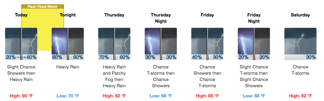
Here is the Harford County area forecast from the National Weather Service:
See Also:
Get more local news delivered straight to your inbox. Sign up for free Patch newsletters and alerts.


