Weather
Harford County Under Flood Warning As Ida Passes Through
As the remnants of Ida pass through, the National Weather Service is warning Harford County to avoid water-covered roads.


HARFORD COUNTY, MD — Those in Harford County should be on alert for flooding Wednesday after inches of rain fell while the remnants of Post Tropical Cyclone Ida moved through the region.
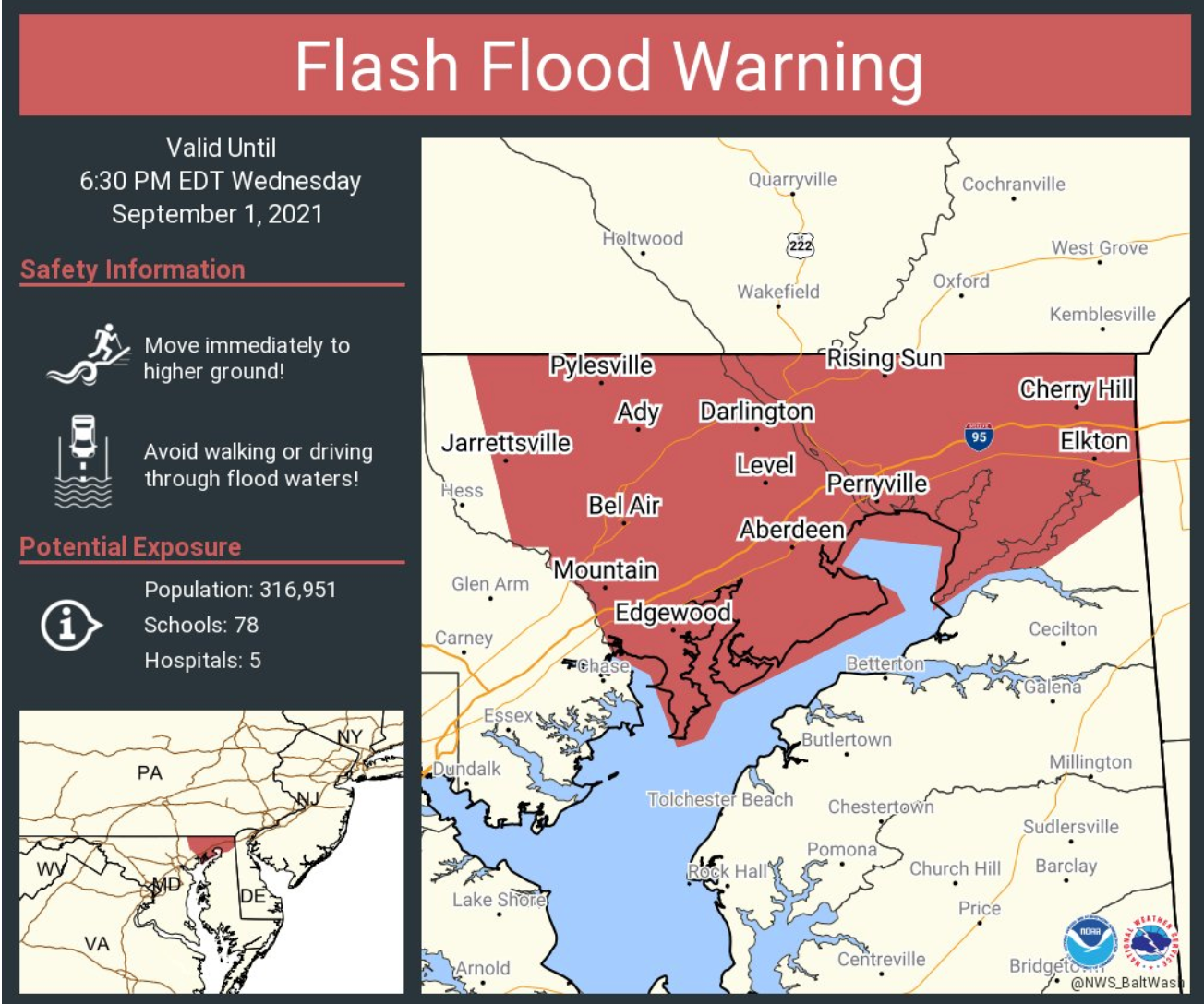
A flood warning is in effect for Harford and Cecil counties until midnight after the National Weather Service said flooding was reported.
About 2 to 4 inches of rain had fallen in the two counties after 6 p.m., officials said.
Find out what's happening in Bel Airfor free with the latest updates from Patch.
These areas will experience flooding, according to the warning: Elkton, Aberdeen, Havre de Grace, Aberdeen Proving Ground, Calvert, Bel Air South, Bel Air North, Fallston, Riverside, Kingsville, North East, Pleasant Hills, Jarrettsville, Rising Sun, Perryman, Charlestown, Octoraro, Conowingo, Richardsmere and West Nottingham.
Authorities warned to watch out for these flood-prone roads:
Find out what's happening in Bel Airfor free with the latest updates from Patch.
- Walters Mill Road at Ady Road
- Montreal Drive at Grays Run
- Bush Chapel Road at Cranberry Run
- Mitchell Lane at Pulaski Highway
- Old Philadelphia Road at Route 715
- Erie Street at Pulaski Highway
- Juniata Street and Otsego Street
- Bel Air Road at Little Gunpowder Fall
- Route 7 at Hall Street
- Patterson Mill Road at Wheel Road
- Shawnee Drive at Walters Mill Road
- Philadelphia Road near James Run
- Sandy Hook Road near Deer Creek
- Darlington Road at Deer Creek Road
- Conowingo Road near Bynum Run
- Southampton Road at Bynum Run
- Moores Mill Road at Bynum Run
- Foxborough Drive
- Plumtree Road at Plumtree Run
This includes the following streams, officials said: Haha Branch, Stony Run, Canal Creek, Zirkle Branch, Laurel Run, Bohemia River, Octoraro Creek, Gasheys Creek, Little North East Creek, West Branch Little Northeast Creek, Bird River, Stone Run, West Branch Winters Run, Cranberry Run, Island Branch, Sod Run, Stout Bottle Branch, Big Elk Creek, James Run, Winters Run, Love
Run, Cattail Branch, Deer Creek, Stirrup Run, East Branch Laurel Run, Elbow Branch, Little Deer Creek, North Stirrup Run, Broad Creek, Deep Creek, Thomas Run, Graveyard Creek, Plumtree Run,
North East Creek, Kellogg Branch, Bear Cabin Branch, Gunpowder Falls, Conowingo Creek, Little Gunpowder Falls, Susquehanna River, Mill Creek, Plum Creek, Back Creek, Little Romney Creek, Basin Run, Broad Run, Rock Hollow Branch, Long Branch, Little Elk Creek, Bynum Run, Swan Creek, Cod Creek, Wildcat Branch, Principio Creek and Perch Creek.
EXPIRED: With heavy rain covering roads in northeastern Maryland, the National Weather Service has also placed Harford and Cecil counties under a flash flood warning until 6:30 p.m.
Officials said 1 to 2.5 inches of rain had fallen in Harford and Cecil counties as of 3:30 p.m., with another 1 to 3 inches of rain possible on top of that.
"Flash flooding is ongoing or expected to begin shortly," the National Weather Service warned.
Flash flooding, or a rapid rise in water level, can be life-threatening. Drivers who come upon water-covered roads should turn around; don't drown.
Want the latest developments? Get news alerts from Patch.
These areas may experience flash flooding, according to the warning: Aberdeen, Aberdeen Proving Ground, Bel Air North, Bel Air South, Fallston, Havre de Grace Jarrettsville, Kingsville, Perryman, Pleasant Hills, Conowingo, Rising Sun, Elkton and North East.
A tornado watch remains in effect until 7 p.m., and Harford County is under a flash flood watch until 8 a.m. on Thursday.
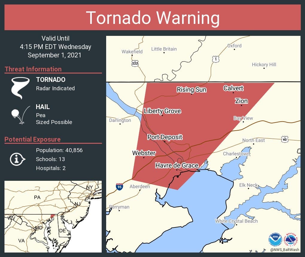
EXPIRED: A tornado warning was issued for northeastern Harford County until 4:15 p.m.
At 3:49 p.m., a storm capable of producing a tornado was detected near Havre de Grace, prompting the weather service to issue a tornado warning. It was moving north at 30 mph, officials said.
Flying debris could endanger those who are outside. People should move inside away from windows to stay safe, officials advised.
See Also:
- Tornado Watch Issued For Harford; Cancellations Announced
- Bel Air Prepares For Tropical Depression Ida
- Tornado Watch Issued For 16 MD Counties, Baltimore City Sept. 1
- Ida Remnants Threaten Heavy Rain, Floods, Power Outages In MD
- Havre de Grace Warns Residents Of Ida As Flash Flood Watch Issued
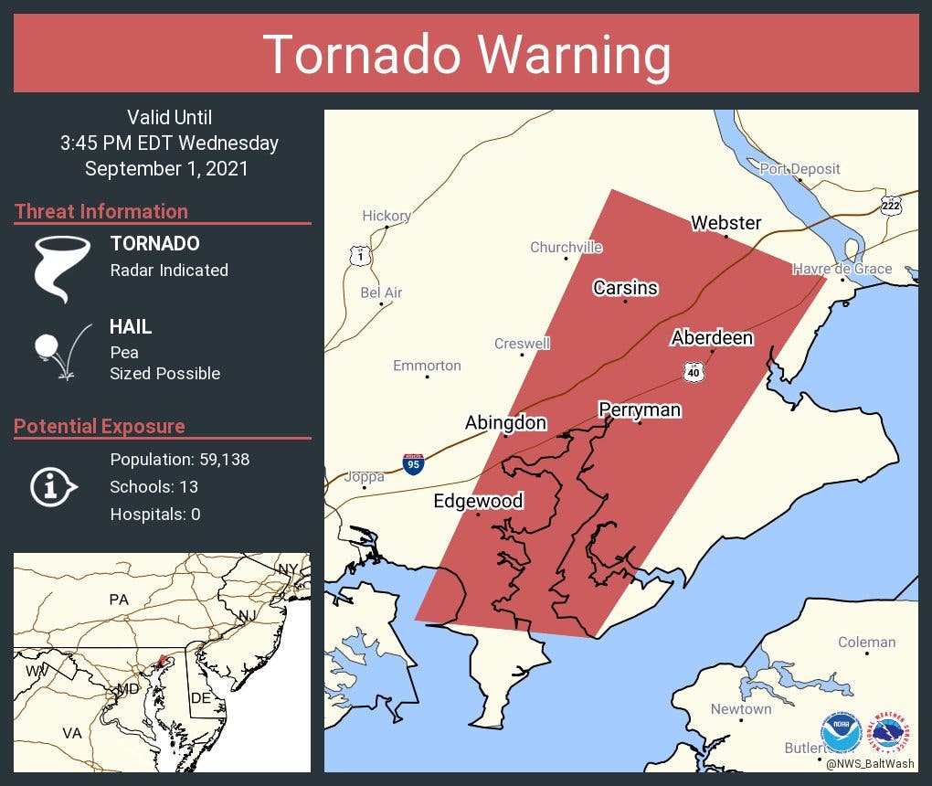
EXPIRED: A storm capable of producing a tornado sparked a tornado warning from the National Weather Service.
The tornado warning was in effect until 3:45 p.m. on Wednesday for parts of Harford County but was allowed to expire around 3:40 p.m. after officials said the storm weakened.
Radar had indicated a storm with rotation near Perryman at 3:15 p.m. that was moving northeast at 40 mph, according to the National Weather Service.
The storm was likely to arrive in these areas, according to the National Weather Service:
- Riverside at 3:30 p.m.
- APG at 3:35 p.m.
- Havre de Grace at 3:40 p.m.
Other areas that may be affected included Carsins, Belcamp and Edgewood.
A tornado watch remains in effect until 7 p.m., and Harford County is under a flash flood watch until 8 a.m. on Thursday.
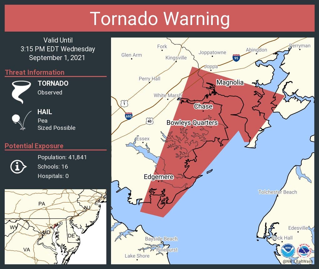
EXPIRED: After a storm with a history of tornadic damage was detected over North Point State Park, the National Weather Service placed parts of Harford and Baltimore counties under a tornado warning Wednesday afternoon.
A tornado warning for south-central Harford County was in effect until 3:15 p.m.
A tornado was detected near Fort Howard and the mouth of the Patapsco River at 2:46 p.m., according to the National Weather Service, which stated it was moving northeast at 35 mph.
These areas are under the tornado warning: Middle River, North Point State Park, Back River, Millers Island, Dundalk, Essex, Bowleys Quarters, Edgewood, Joppatowne, Edgemere, Fort Howard, Magnolia, Chase, Bradshaw, Martin State Airport and Gunpowder.
"This storm has a history of tornadic damage. TAKE COVER NOW!" the National Weather Service warned. "Move to a basement or an interior room on the lowest floor of a sturdy building. Avoid windows. If you are outdoors, in a mobile home, or in a vehicle, move to the closest substantial shelter and protect yourself from flying debris."
EXPIRED: Parts of Harford County are under a tornado warning Wednesday afternoon.
Radar detected a severe thunderstorm capable of producing a tornado at 2:26 p.m. near Cockeysville that was moving north at 30 mph, according to the National Weather Service.
It will be near Jarrettsville around 2:40 p.m., according to the National Weather Service, which placed northwestern Harford County under the tornado warning.
Flying debris could endanger those who are outside. People should move inside away from windows to stay safe, officials advise.
The tornado warning remains in effect until 3 p.m.

@NWS_BaltWash has issued a tornado warning for #Harford. Please monitor approaching storms and take cover if necessary. Thanks & be safe. pic.twitter.com/ib4xELhBo0
— Harford County Gov't (@HarfordCountyMD) September 1, 2021
Get more local news delivered straight to your inbox. Sign up for free Patch newsletters and alerts.