Weather
Maryland Weather: Snowfall Estimates, Timing For Weekend Storm
Much of Maryland is under a winter storm watch with snow expected this weekend.

MARYLAND — Snow is in the forecast this weekend, and the winter storm may be "tricky," according to the Maryland Emergency Management Agency (MEMA).
Winter weather is expected to impact Maryland early Sunday through Tuesday.
"I'm being told this is a tricky storm to forecast — keep checking back over the weekend and keep your communications devices charged up," Chas Eby, deputy director for MEMA, said in a statement Friday afternoon.
Find out what's happening in Bel Airfor free with the latest updates from Patch.
For the latest on Maryland weather, get Patch news alerts.
Flakes may begin falling early Sunday morning, becoming more steady in the afternoon then mixing with sleet and freezing rain Sunday night. It is expected to change to rain by Monday morning, officials say.
Find out what's happening in Bel Airfor free with the latest updates from Patch.
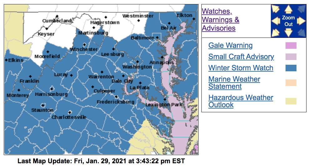
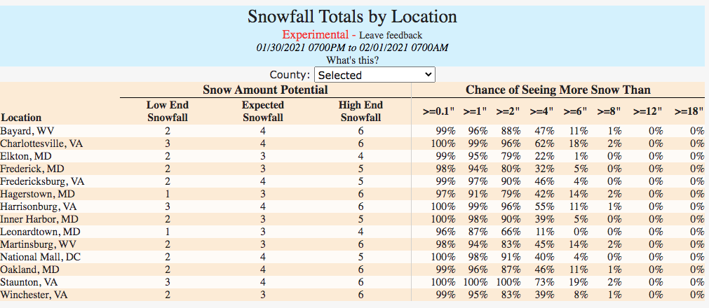
A winter storm watch is in effect for much of the state calling for 5 or more inches of heavy snow from Sunday to Monday morning:
- The watch runs from 1 a.m. Sunday to 1 a.m. Monday for Anne Arundel, Calvert, Charles, Howard, Montgomery, Prince George's and St. Mary's counties.
- The winter storm watch is from 6 a.m. Sunday to 6 a.m. Monday for Baltimore, Cecil and Harford counties and Baltimore City.
Roads may be slippery, and snow could impact the Monday morning commute.
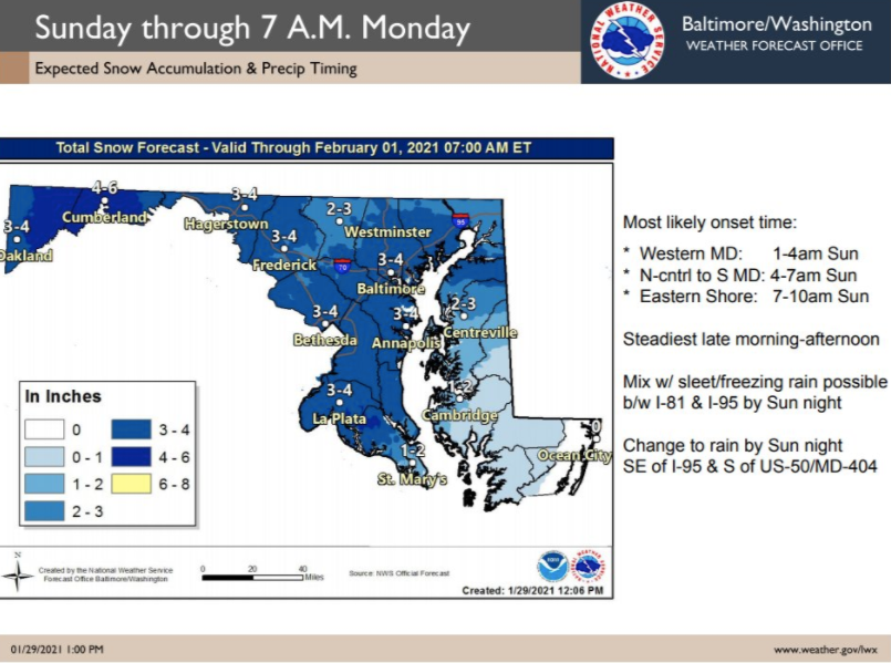
After Sunday's storm, another round of winter weather could drop up to several inches of snow west of the Chesapeake Bay and in Cecil County through Monday night, according to MEMA.
A few inches of snow may also fall on the Eastern Shore, except far southeast Maryland, which could see additional rainfall.
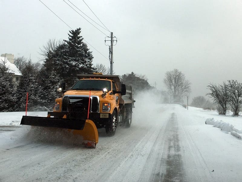
The Maryland State Highway Administration began pretreating roads Friday morning to protect them from ice in western Maryland and anticipates covering the rest of the state by Saturday morning.
State transportation officials advise drivers to "take it slow on ice and snow," give plows a wide berth and stay alert on ramps, bridges and overpasses, which may freeze first.
While the amount of accumulation is uncertain, authorities say drivers should be cautious even if it appears to be a light coating.
"Even small amounts of snow can cause big headaches for motorists," said John B. Townsend II, spokesman for AAA Mid-Atlantic.
"It seems some people in the Washington metro area tend to forget how to drive in the snow and on ice — especially during the first major snowstorm of the season," Townsend said. "With less traffic and fewer drivers on our roads because of coronavirus pandemic, speeding has emerged as a serious problem over the past year, and there have been more fatalities as a result. It is critical that motorists slow down and take extra precautions, as wintry conditions impact the region and its roads."
A hazardous weather outlook for the I-95 corridor and the Maryland part of the Chesapeake Bay and Tidal Potomac calls for an "enhanced winter storm threat" Sunday and Sunday night, with a "slight winter storm threat" Monday and Monday night.
"If the threat materializes, it may cause travel disruptions," according to the outlook.
These areas are under a hazardous weather outlook: Anne Arundel, Baltimore, Calvert, Harford, Howard, Montgomery, St. Mary's and Prince George's counties.
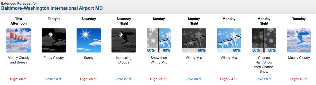
Here is the latest Baltimore-Washington forecast from the National Weather Service:
Minor coastal and tidal flooding could occur Sunday into Monday, and gale conditions may sweep through the region Monday to Tuesday, MEMA advised.
A gale warning is in effect for the Maryland portion of the Chesapeake Bay, the Tidal Potomac River, and adjoining tidal estuaries from 6 a.m. to 6 p.m. Friday calls for wind gusts up to 40 mph, which could create dangerous waves that may capsize or damage vessels.
A small craft advisory is in effect from 6 p.m. Friday to 6 p.m. Saturday. Early Friday morning, weather officials issued a special marine statement alerting boaters that strong northwesterly winds "will result in blow-out tides across the Chesapeake Bay, Tidal Potomac" and adjacent estuaries.
"Water levels will be more than 1 foot below normal," according to the statement, which says boaters should check navigation charts and be sure not to ground their vessels, especially when going away from the main channel.
Get more local news delivered straight to your inbox. Sign up for free Patch newsletters and alerts.