Weather
Bomb Cyclone Targeting MD: See Latest Timing, Snow Potential
A rapidly intensifying winter storm on the Atlantic Coast could bring blizzard conditions to parts of MD this weekend. See snow estimates.

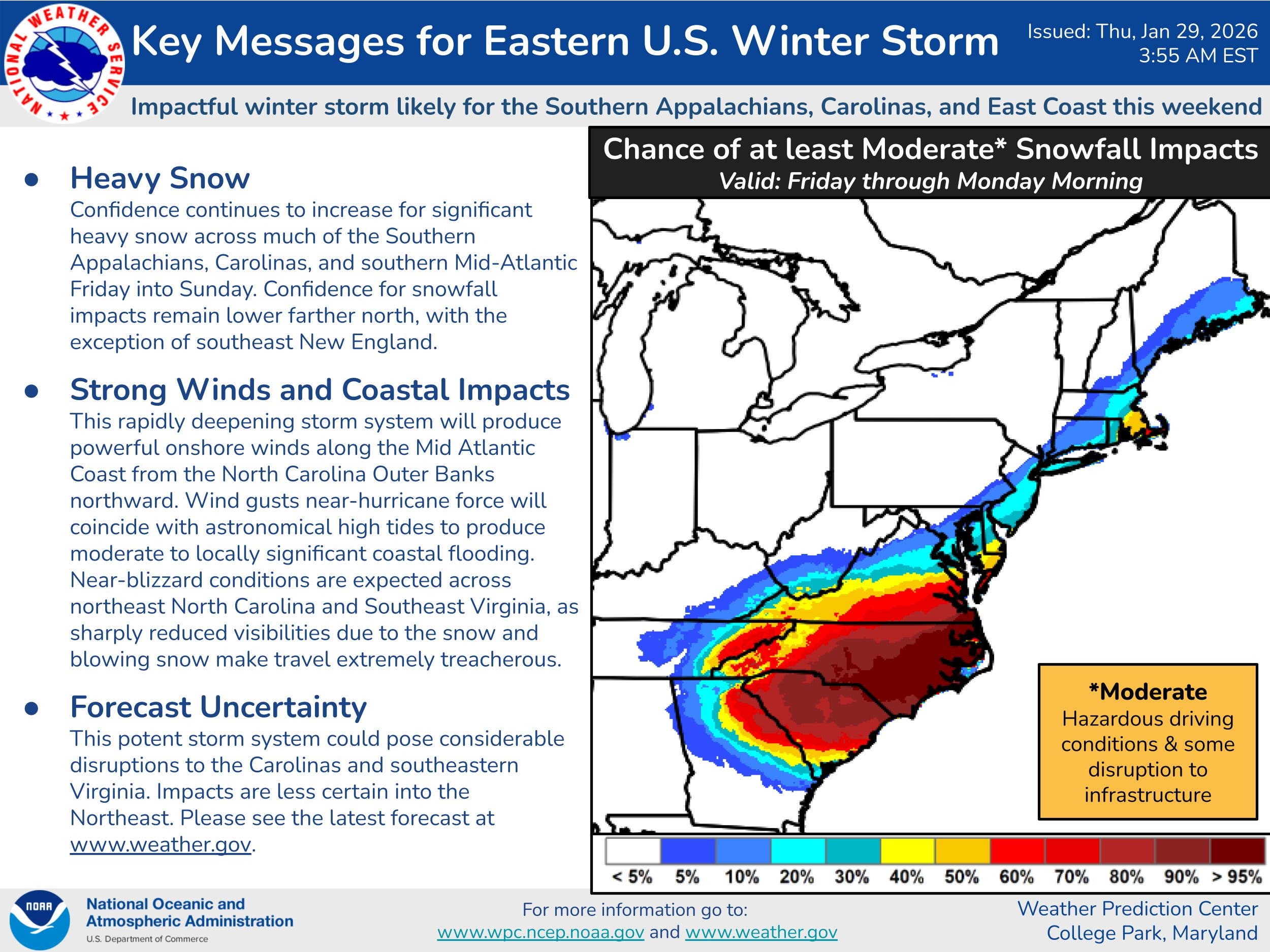
A rapidly intensifying storm is forecast to strengthen into a bomb cyclone along the Atlantic Coast this weekend and could bring heavy snow, blizzard conditions and strong winds to parts of Maryland, according to the latest forecasts.
In an update released Thursday morning, AccuWeather forecasters said the storm is expected to develop in the Southeast on Friday, then rapidly strengthen along the Atlantic Coast into a bomb cyclone by Saturday.
As it intensifies, forecasters said snow coverage and wind speeds will increase from the Southeast to the Northeast coast.
Find out what's happening in Germantownfor free with the latest updates from Patch.
"People need to prepare for the possibility of dangerous blizzard conditions in some coastal areas from North Carolina to the southern Jersey shore," AccuWeather senior meteorologist Scott Homan said. "Blizzard conditions may reach parts of Long Island and southern New England."
.jpg)
According to forecasts, the storm's greatest impacts will mostly be felt south of Maryland; however, cities located on the southern tip of the Delmarva Peninsula could receive anywhere from 6-12 inches of snow, accompanied by blizzard conditions and possible coastal flooding.
Find out what's happening in Germantownfor free with the latest updates from Patch.
"With a full moon this weekend, astronomical tides will be higher than normal. That means even a modest storm surge can push water much farther inland than people expect," Homan said. "Coastal residents need to be prepared for flooding near high tide."
For the Baltimore region, chances for significant snowfall are less. AccuWeather predicts the area could receive 1-3 inches of snow from Friday to Sunday, as well as 30 to 50 mph wind gusts. The National Weather Service's Weather Prediction Center said the region has a 10 to 20 percent chance of seeing moderate snowfall.
Meanwhile, bitterly cold temperatures are expected to linger well into next week with wind chill values falling below zero on occasion. A cold weather advisory once again goes into effect on Thursday at 7 p.m. The advisory expires at 11 a.m. on Friday.
According to the National Weather Service, wind chills as low as 9 below zero are expected across central, northeast, northern and southern Maryland.
"Frostbite and hypothermia will occur if unprotected skin is exposed to these temperatures," forecasters said. "Wind chill values can lead to hypothermia with prolonged exposure."
Here's a look at the latest National Weather Service forecast for the region:
Thursday: Mostly sunny, with a high near 22. West wind 10 to 14 mph, with gusts as high as 23 mph.
Thursday Night: Mostly clear, with a low around 3. Northwest wind 3 to 6 mph.
Friday: Mostly sunny, with a high near 21. Wind chill values as low as -4. Northwest wind 3 to 6 mph.
Friday Night: Mostly cloudy, with a low around 6. Wind chill values as low as -3. Calm wind becoming north around 5 mph after midnight.
Saturday: A slight chance of snow after 1pm. Mostly cloudy, with a high near 20. North wind 6 to 10 mph. Chance of precipitation is 20%.
Saturday Night: A chance of snow. Mostly cloudy, with a low around 11. Chance of precipitation is 30%.
Sunday: Mostly cloudy, with a high near 25.
Sunday Night: Partly cloudy, with a low around 15.
Monday: Sunny, with a high near 32.
Get more local news delivered straight to your inbox. Sign up for free Patch newsletters and alerts.