Weather
Avoid Pulaski Highway, Baltimore County Emergency Officials Warn
Water rescues have been reported on US 40/Pulaski Highway, Baltimore County officials say.

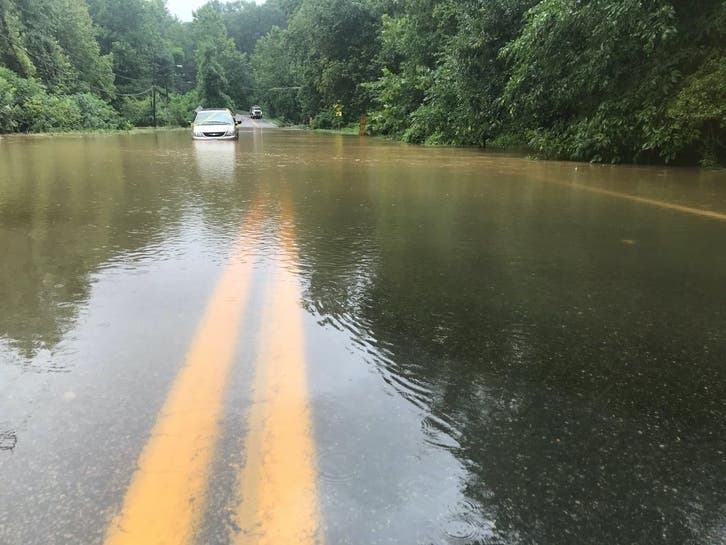
BALTIMORE, MD — Firefighters said they rescued two people from a vehicle stuck in floodwaters in Rosedale Saturday afternoon in Baltimore County. Emergency personnel have advised drivers to avoid US 40/Pulaski Highway altogether, as there have been multiple water rescue calls there.
The rescues came as parts of Baltimore County and Baltimore City are under a flash flood warning. During a flash flood warning, officials say flash flooding — a rapid rise in water level that can be life-threatening — is imminent or occurring.
At 4:15 p.m., the Baltimore County Volunteer Firefighter's Association reported two people were saved after they had been trapped in a vehicle in floodwaters on Pulaski Highway/US 40 at Contractors Road in Rosedale.
Find out what's happening in Perry Hallfor free with the latest updates from Patch.
Radar showed 1.5 to 2.5 inches of rain had fallen in parts of the Baltimore area as of 3:30 p.m., according to the National Weather Service, which reported 1 to 2 inches more could fall during the flash flood warning period. The flash flood warning is in effect until 6:30 p.m. Saturday.
"There have been several water rescue calls along Pulaski Highway in the Rosedale area. Other roads on the east side of the county are also flooded," Baltimore County Emergency Management reported after 4:30 p.m. Officials advised people to "AVOID Pulaski Highway and find another route" as well as turn around if they see high water on other roads.
Find out what's happening in Perry Hallfor free with the latest updates from Patch.
These areas may experience flash flooding, according to authorities: Baltimore, Middle River, Dundalk, Towson, Essex, Parkville, Carney, Perry Hall, Rosedale, Rossville, White Marsh, Hampton, Edgemere, Fullerton, Eastpoint, Nottingham, Loch Raven Village, Loch Raven, Eudowood and Martin State Airport.
"Be aware of your surroundings and do not drive on flooded roads," the flash flood warning states. "Turn around — don't drown — when encountering flooded roads. Most flood deaths occur in vehicles."
There have been several water rescue calls along Pulaski Highway in the Rosedale area. Other roads on the east side of the county are also flooded.
-AVOID Pulaski Highway and find another route
-Do NOT drive into high water on any roads
-If you see a flooded road, turn around! pic.twitter.com/EVyX4ENko3
— Baltimore County Emergency Management (@BaltCoEmergency) July 17, 2021
A severe thunderstorm warning was in effect until 4:30 p.m. for parts of Baltimore City, Baltimore County and Harford County.
Officials issued the warning after radar detected a severe thunderstorm over Back River that was moving southeast at 10 mph, the National Weather Service reported. The storm had 60 mph wind gusts and quarter-sized hail, officials said.
During the severe thunderstorm warning period, winds may cause trees and large branches to fall, injuring people outside as well as damaging homes and vehicles. Roads could become blocked by fallen trees, and power outages are possible. People should go inside to the lowest floor and an interior room to stay safe.
These areas may be impacted, according to the warning: Baltimore, Middle River, North Point State Park, Sparrows Point, Back River, Millers Island, Dundalk, Essex, Rosedale, Rossville, White Marsh, Bowleys Quarters, Edgemere, Nottingham, Fort Howard, Chase, Eastpoint, Martin State Airport and Turners Station.
A flash flood watch and severe thunderstorm watch are in effect until 11 p.m. for parts of Maryland, D.C. and Virginia.
Related:
Get more local news delivered straight to your inbox. Sign up for free Patch newsletters and alerts.