Weather
Montgomery Co. Flood Warning Extended: Live Updates, 2-4 Inch Rainfalls Possible
Montgomery County is under a flash flood warning Friday after the area received 2 inches of rain with more on the way.


ROCKVILLE, MD — Montgomery County is under a flash flood warning until 8:15 p.m. an extension of an earlier warning that was to expire Friday afternoon. As of 2:14 p.m., the National Weather Service says the area has received 2 to 4 inches of rain with another inch possible this afternoon. And another round of heavy rain is possible Friday night into Saturday with additional rainfall amounts of two to four inches possible. Additional flash flood warnings may be required, forecasters warn.
Drivers from Maryland, Pennsylvania, New Jersey, West Virginia, Virginia and Delaware are likely to face difficult travel due to persistent downpours, excess water on the road and poor visibility, according to AccuWeather.
Locations that may experience flooding include Germantown, Rockville, Bethesda, Gaithersburg, Olney, Langley Park, Beltsville, Lowes Island, Aspen Hill, Potomac, North Bethesda, Montgomery Village, North Potomac, Fairland, White Oak, Redland, Takoma Park, Great Falls, Adelphi and Colesville.
Find out what's happening in Rockvillefor free with the latest updates from Patch.
Montgomery County Fire and Rescue officials say they are being called to multiple high-water spots Friday afternoon. A fire captain shared this photo of a flooded Gaithersburg street:
Gaithersburg pic.twitter.com/fNXbGjXjua
— Brett Livingston (@bkl5477) July 28, 2017
Find out what's happening in Rockvillefor free with the latest updates from Patch.
Brookeville Road in Olney is closed. Crews onsite @MoCoCouncilMD #MdTraffic pic.twitter.com/3vqjPe42qR
— MC Highway Services (@MontCo_Highways) July 28, 2017
At 2 p.m. Montgomery County Highway Services said on Twitter that "4+ inches of rain has fallen thus far in the majority of #MoCo. Another 4-6 inches of rain is expected tonight."
A heads up to drivers that flood-prone locations in the county include:
DOWN-COUNTY AREAS
- MD 29 (Columbia Pike) at Paint Branch – N. of White Oak
- MD 185 (Conn. Ave) at Rock Creek – S. of Kensington
- MD 190 (River Road) at Cabin John Creek – Potomac
- MD 193 (Univ. Blvd) at Sligo Creek – Wheaton
- MD 586 (Veirs Mill Rd) at Rock Creek – S. of Twinbrook Pkwy
- Beach Drive in Rock Creek Park – Kensington-Chevy Chase
- Sligo Creek Pkwy – Silver Spring-Takoma Park
UP-COUNTY AREAS
- MD 97 (Georgia Ave) at Reddy Branch – N. of Brookeville
- MD 124 (Woodfield Rd) at Goshen Branch and at Gr. Seneca Creek – N. of Brink Rd.
- MD 117 (Clopper Rd) at Gr. Seneca Creek – W. of Gaithersburg
- MD 117 (Clopper Rd) at Little Seneca Creek – E. of Boyds
- MD 355 (Frederick Rd) at Little Seneca Creek – W. of Brink
- MD 121 (Clarksburg Rd) near Little Seneca Lake – N. of Boyds
- MD 118 (Germantown Rd) at Great Seneca Creek – S. of Germantown
- River Rd and Berryville Rd at Seneca Creek
- Blunt Road at Great Seneca Creek – S. of Brink Rd.
- Davis Mill Rd at Great Seneca Creek – N. of Gaithersburg
- Brighton Dam Rd at Hawlings River – NE of Brookeville
- Goldmine Rd at Hawlings River – E of Olney
- Zion Rd at Hawlings River – E. of Laytonsville
- Hoyles Mill Rd at ford of Little Seneca Creek – Germantown, west of the soccer complex
- Loghouse Rd at Magruder Branch – S. of Damascus
- Elton Farm Rd at Haights Branch – N. of Sunshine
- Howard Chapel Rd at Haights Branch – N. of Sunshine
- White’s Ferry Road and River Road – White’s Ferry
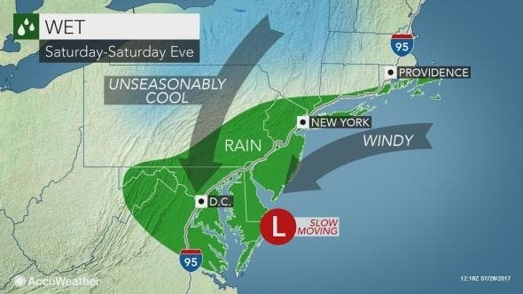
Enough rain can fall to cause flash and urban flooding. Small stream flooding is also possible as several inches of rain may fall on some locations, according to AccuWeather. This threat will be greatest from Philadelphia and Harrisburg, Pennsylvania, to Baltimore and Washington, D.C.
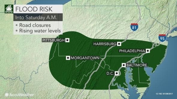
Heavy rainfall forecast for parts of Maryland Friday into Saturday afternoon had already prompted the National Weather Service to issue a flash flood watch for much of the state starting at 2 p.m. Friday and running through 2 p.m. Saturday. Washington, D.C., and much of Northern Virginia is also in the watch area.
Forecasts say 3 inches of rain is possible Friday into Saturday across much of the area. Thunderstorms could cause locally higher rainfall amounts that may result in rapid rises in streams and creeks. This could quickly result in flooding in low lying and poor drainage areas. The watch area includes Anne Arundel, Calvert, Carroll, Howard, Baltimore, Harford, Montgomery and Prince George's counties, along with the District of Columbia.
A line of showers and thunderstorms is expected in the region after 2 p.m. Friday, the Weather Service says. Some of the storms could produce heavy rainfall, between three quarters and one inch is possible. Friday night showers will continue and thunderstorms could produce heavy rainfall. Those storms could produce another 1 to 2 inches. (SIGN UP: Get Patch’s daily newsletter and real-time news alerts, or like us on Facebook. Or, if you have an iPhone, download the free Patch app.)
A flash flood watch means that conditions may develop that lead to flash flooding. Flash flooding is a very dangerous situation. You should monitor later forecasts and be prepared to take action should Flash Flood Warnings be issued.
The weather service urges residents to take precautions ahead of the rainfall. Be sure to:
- If you are near streams or drainage ditches keep an eye on them and be ready to quickly seek higher ground. Water may rise rapidly.
- Clear out storm drains.
- Those prone to basement flooding should prepare.
- Communities prone to flooding should prepare.
In Anticipation of Flooding:
- If possible, clear storm drains of leaves and debris and check gutters.
- If your basement is prone to flooding, move valuables to a higher location.
- Store valuables and important personal papers in a waterproof container.
- Avoid areas subject to flooding, including low spots, canals and streams. Know alternate routes to avoid those areas.
- Remember, never attempt to drive over a flooded road – you can be stranded or trapped. The depth of the water and the condition of the road is not always obvious and very difficult to determine at night.
Flooding Facts:
- Flash floods develop from intense storms dropping large amounts of water in a short time. Flash floods occur with little or no warning. During periods of urban flooding, streets can become swift moving rivers and basements can fill with water.
- If a Flash Flood Warning, issued when flooding is imminent or occurring, goes into effect, take immediate precautions.
- In many cases it takes less than a foot of water to incapacitate a vehicle.
- A foot of water will float many vehicles; two feet of rushing water will carry away most vehicles including SUV’s and pick-up trucks.
- Swiftly moving floodwaters of six inches will reach the bottom of most passenger cars causing lack of control and possible stalling.
- Roads covered by floodwaters could already be washed away; don’t drive across roads that are not visible.
- Heed all flooding alerts and warnings from public safety officials.
Driving Precautions during Heavy Rain and Flooding:
- Always exercise caution on roadways during periods of heavy rain: use headlights whenever you use windshield wipers, reduce speeds and maintain a safe distance between vehicles.
- Know your location and do not become distracted while driving. If you need public safety assistance, you need to be able to provide your specific location.
- If you encounter high water, turn around and drive to a safe spot. Call the police non-emergency number (301) 279-8000 to report the situation to emergency personnel.
- Never drive around a street barricade.
- If your vehicle is trapped in high water call 9-1-1 for rescue. Get out and go to higher ground if you can safely do so.
- Six inches of water can sweep a person off their feet and rocks, tree limbs and other debris can be caught in moving water and be dangerous to you when walking, wading or swimming through flood waters.
- If you have to walk or wade through flood water, use a stick to poke the ground in front of you to determine depth and any underwater debris.
- For emergencies, call 911 immediately. For information about County programs and services, call 3-1-1 (use 240-777-0311 for cell phones), between 7 a.m. and 7 p.m. or go anytime to the call center’s online portal at www.MC311.com. The hours at the MC311 call center will be extended this weekend if weather conditions warrant.
To stay informed during a severe weather event, major crisis or other type of emergency, sign up for the County’s “Alert Montgomery” emergency warning system. Learn more at: http://www.montgomerycountymd.gov/OEMHS/AlertMontgomery.
— Patch Editor Tom Davis contributed reporting
»Graphics from the National Weather Service, photo from Shutterstock
Get more local news delivered straight to your inbox. Sign up for free Patch newsletters and alerts.