

Forecasters are warning of intense weather early Sunday morning into the afternoon. Even a slight risk of a tornado exists among the more widely anticipated threat of strong-to-severe thunderstorms and tropical downpours. Below is the latest information from forecasters as of 1 a.m. Sunday.
You can see the timeline and simulated radar for Sunday here.
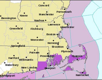
The National Weather Service had issued a hazardous weather outlook for the whole state, with parts of Southeastern Mass. and the Cape & Islands under a high surf advisory. The water along the coast was under a gale warning.
Find out what's happening in Bostonfor free with the latest updates from Patch.
Urban localized flooding is a possibility early Sunday morning through Sunday afternoon, according to the NWS. There remains a low chance of a brief tornado. "The threat for a brief tornado/waterspout appears to be diminishing...but still can not be completely ruled out," the NWS said.
[Saturday Night → Sunday] Tropical downpours w/ rainfall rates of 1-2" / hr possible, 1-3" in total possible; threat of urban / poor drainage flooding; also gusty winds 30-35 mph & the non-zero chance of a brief spin-up of a tornado / waterspout; bulk of impacts 3a - 10a Sunday pic.twitter.com/7tMXlglDr0
— NWS Boston (@NWSBoston) July 20, 2018
Here are the last two tweets from the NWS on Saturday:
Find out what's happening in Bostonfor free with the latest updates from Patch.
[Localized Flash Flooding/Isolated Severe Weather Threat] Showers and embedded t-storms will bring localized torrential rainfall overnight/Sun. Localized urban flash flooding is possible. There also is the low risk for an isolated severe t-storm or two with damaging wind gusts. pic.twitter.com/j6Uk9Vn3QV
— NWS Boston (@NWSBoston) July 21, 2018
[Timing] The main time of concern for bands of showers/embedded thunderstorms is after midnight into Sunday afternoon. Torrential rainfall and localized urban flash flooding remains the biggest concern, but the low risk continues for an isolated severe thunderstorm or two.
— NWS Boston (@NWSBoston) July 21, 2018
The Massachusetts Emergency Management Agency was operating at a Level 1 in its Framingham headquarters. It offers safety tips on thunderstorms/lightning, tornados, and floods.
Meanwhile, AccuWeather is saying this is just the beginning of a wet weather pattern for the rest of July. The website said this much wet weather isn't typical of the middle of summer when a tropical storm isn't present.
"It's probably more likely that summer is going to take a long break with some hope for sunny, hot weather during the middle to latter part of August," AccuWeather Lead Long-Range Meteorologist Paul Pastelok said.
-1532232909-8953.jpg)
Image via shutterstock
Get more local news delivered straight to your inbox. Sign up for free Patch newsletters and alerts.


