Weather
It Will Feel Like 105 Degrees In The Twin Cities: Heat Warning
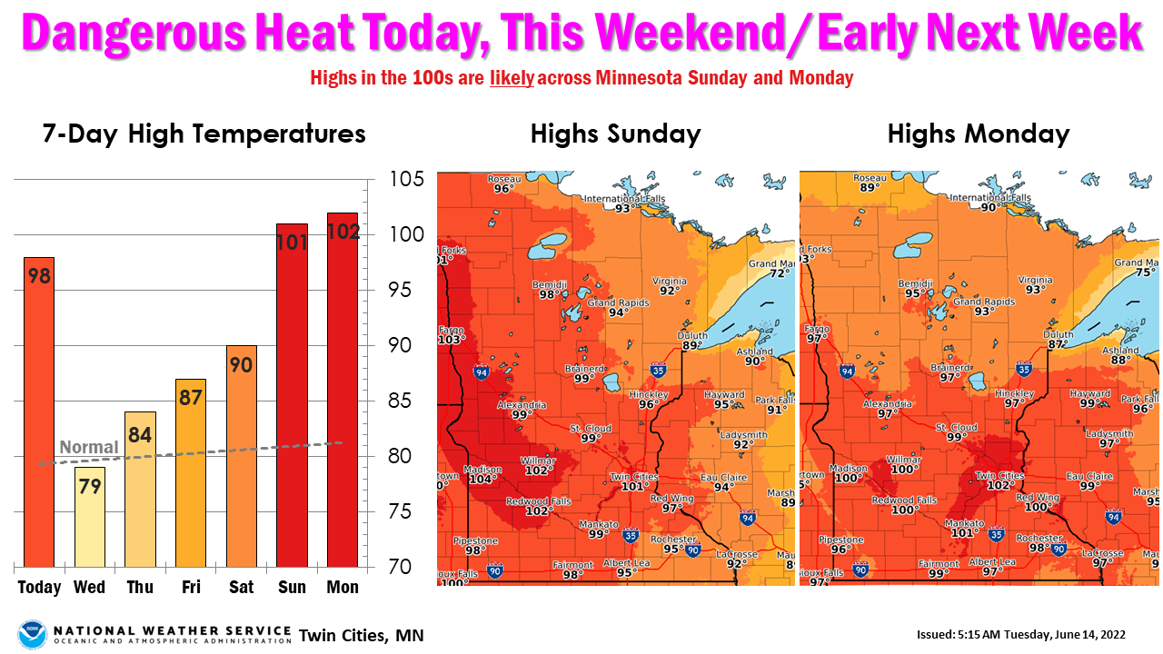
The National Weather Service has issued an excessive heat warning for the Twin Cities metro. More extreme heat is in the weekend forecast.


TWIN CITIES, MN — An excessive heat warning for the Twin Cities metro area will go into effect at 11 a.m. on Tuesday. The warning covers Scott, Carver, Washington, Ramsey, Anoka, Hennepin and Dakota County.
"Dangerously hot" conditions with heat index values up to 105 are expected, the National Weather Service said.
"Extreme heat and humidity will significantly increase the potential for heat related illnesses, particularly for those working or participating in outdoor activities."
Find out what's happening in Southwest Minneapolisfor free with the latest updates from Patch.
Minneapolis Public Schools announced that schools that are not fully air-conditioned will move to e-learning Tuesday due to the dangerously hot temperatures in the forecast.
More heat is expected to arrive this weekend.
Find out what's happening in Southwest Minneapolisfor free with the latest updates from Patch.
The NWS provided the following tips to stay safe during the heatwave:
- Drink plenty of fluids, stay in an air-conditioned room, stay out of the sun, and check up on relatives and neighbors
- Young children and pets should never be left unattended in vehicles under any circumstances
- Take extra precautions if you work or spend time outside
- When possible reschedule strenuous activities to early morning or evening
- Know the signs and symptoms of heat exhaustion and heat stroke
- Wear lightweight and loose-fitting clothing when possible
- To reduce risk during outdoor work, the Occupational Safety and Health Administration recommends scheduling frequent rest breaks in shaded or air-conditioned environments
- Anyone overcome by heat should be moved to a cool and shaded location.
- Heat stroke is an emergency! Call 911.
Here’s the full NWS forecast from the Minneapolis-St. Paul International Airport:
Wednesday: A chance of showers and thunderstorms before 7am, then showers likely and possibly a thunderstorm between 7am and 1pm, then a chance of showers and thunderstorms after 1pm. Cloudy, then gradually becoming mostly sunny, with a high near 79. Light and variable wind becoming west southwest 5 to 10 mph in the morning. Chance of precipitation is 70%. New rainfall amounts between a quarter and half of an inch possible.
Wednesday Night: Mostly clear, with a low around 64. Southwest wind around 10 mph.
Thursday: Sunny, with a high near 84. Breezy, with a west southwest wind 15 to 20 mph, with gusts as high as 40 mph.
Thursday Night: Clear, with a low around 63. Breezy, with a west northwest wind 10 to 20 mph, with gusts as high as 35 mph.
Friday: Sunny, with a high near 86. North wind 5 to 10 mph.
Friday Night: Clear, with a low around 65. Northeast wind 5 to 10 mph becoming east southeast after midnight.
Saturday: Sunny, with a high near 90. Southeast wind 10 to 15 mph.
Saturday Night: Mostly clear, with a low around 73. South southeast wind 10 to 15 mph.
Sunday: Sunny and hot, with a high near 101. South southwest wind around 15 mph, with gusts as high as 25 mph.
Get more local news delivered straight to your inbox. Sign up for free Patch newsletters and alerts.


