Weather
Thunderstorms, Tornadoes Possible In Historic Storm: MN Weather
Wind gusts exceeding 80 mph could cause widespread damage Wednesday night, the National Weather Service warned.


TWIN CITIES, MN — The National Weather Service has issued multiple alerts for much of central Minnesota, including the Twin Cities metro area as it warns of a "volatile day of weather" that has not been seen before in mid-December. Thunderstorms and tornadoes could develop Wednesday night in what is set to be a historic weather event.
A high wind warning will go into effect at 9 p.m. Wednesday. Widespread wind damage from gusts possibly exceeding 80 mph is possible. A hazardous weather outlook is in effect and the agency has also issued a special weather statement.
Here is the special weather statement from the NWS:
Find out what's happening in Southwest Minneapolisfor free with the latest updates from Patch.
An unprecedented outbreak of severe thunderstorms for this time of year is likely early this evening. The line of thunderstorms will race northeast across southern and eastern Minnesota into Wisconsin between 5 PM and 9 PM. Widespread wind damage from gusts possibly exceeding 80 mph will accompany the storms. Tornadoes are also possible. The highest risk of severe thunderstorms is southeast of a line from Redwood Falls to Rush City. Storms will be moving between 60 and 70 mph!
Conditions will deteriorate very quickly. Unless preparations are made ahead of time, it may be hard to take adequate shelter when one notices storms beginning to approach. These are expected to be high end damaging wind producers, so pay close attention to warnings issued later today.
Another historical weather day is forecast today with 2 never-before-seen outlooks issued: 1) First Moderate Risk area in the IA/MN/WI region during the month of December in @NWSSPC history. pic.twitter.com/CMBJSsB2NP
— National Weather Service (@NWS) December 15, 2021
Temperatures will plummet as a cold front arrives overnight, causing a flash freeze.
Find out what's happening in Southwest Minneapolisfor free with the latest updates from Patch.
Here's the full NWS forecast for the Twin Cities metro area:
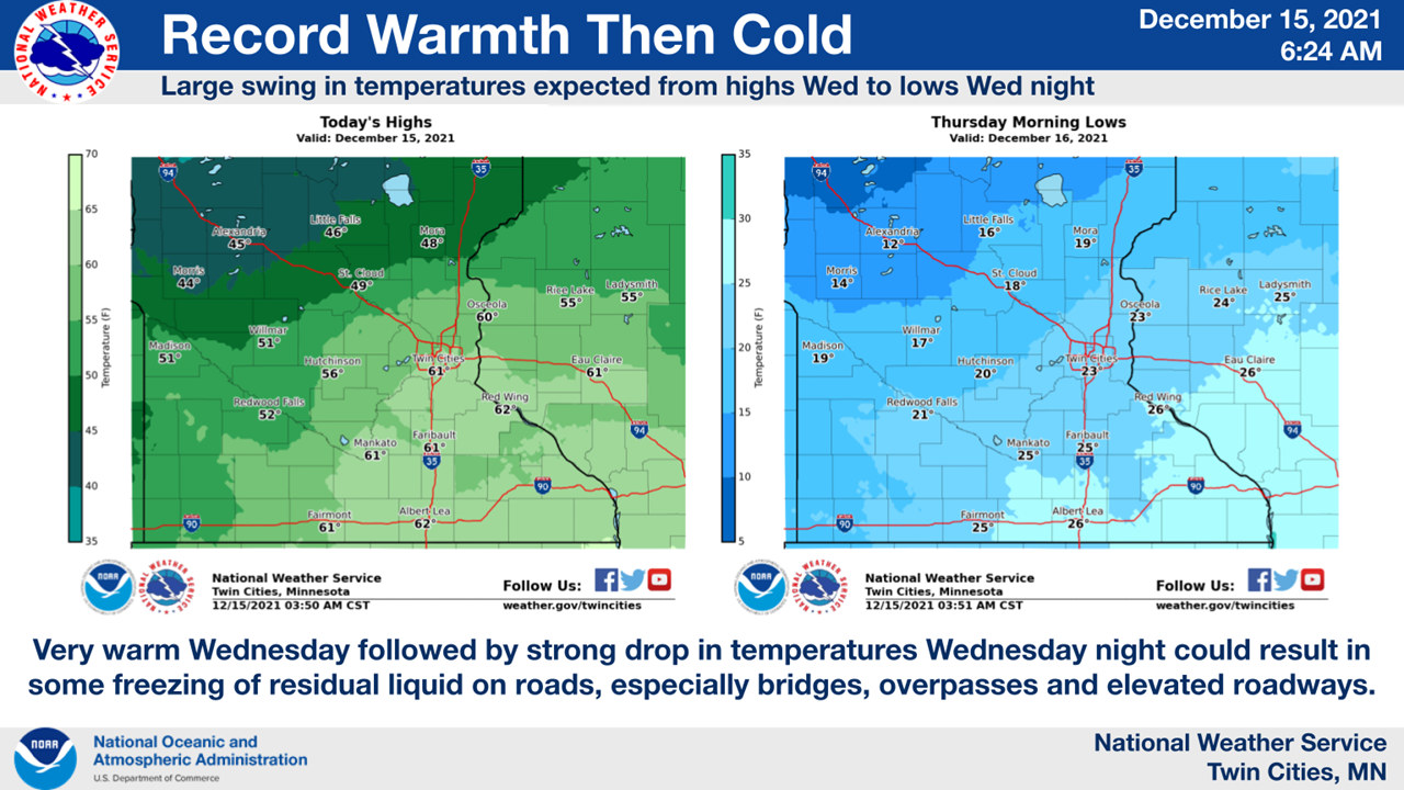
Wednesday: A chance of showers, with thunderstorms also possible after 5pm. Some storms could be severe, with damaging winds. Areas of fog before 9am. Otherwise, mostly cloudy, with a high near 61. South southeast wind around 10 mph, with gusts as high as 25 mph. Chance of precipitation is 40%.
Wednesday Night: Rain showers, snow showers, and freezing rain before 3am, then a slight chance of snow showers and freezing drizzle between 3am and 4am. Some thunder is also possible. Low around 23. Windy, with a south southeast wind 15 to 25 mph becoming west 25 to 35 mph in the evening. Winds could gust as high as 60 mph. Chance of precipitation is 100%. Little or no ice accumulation expected. Little or no snow accumulation expected.
Thursday: Mostly cloudy, then gradually becoming sunny, with a high near 26. Breezy, with a west wind 20 to 25 mph decreasing to 15 to 20 mph in the afternoon. Winds could gust as high as 40 mph.
Thursday Night: Increasing clouds, with a low around 17. West wind 5 to 10 mph becoming north after midnight.
Friday: A 20 percent chance of snow after noon. Mostly cloudy, with a high near 23. Northeast wind around 5 mph.
Friday Night: A 20 percent chance of snow. Mostly cloudy, with a low around 15. Northeast wind 5 to 10 mph becoming northwest after midnight.
Saturday: Partly sunny, with a high near 18. West northwest wind 5 to 10 mph.
Saturday Night: Partly cloudy, with a low around 9. West northwest wind around 5 mph becoming calm.
Sunday: Partly sunny, with a high near 30. South southeast wind 5 to 15 mph.
Sunday Night: Mostly cloudy, with a low around 19. South southeast wind around 10 mph becoming west southwest after midnight.
Monday: Mostly sunny, with a high near 25. West northwest wind 10 to 15 mph.
Monday Night: Partly cloudy, with a low around 11. West northwest wind 5 to 10 mph.
Tuesday: Partly sunny, with a high near 24. West northwest wind around 5 mph becoming south southwest in the morning.
Get more local news delivered straight to your inbox. Sign up for free Patch newsletters and alerts.


