Weather
Snow Total Projections Shift As Weekend Storm Arrives In NJ
Major impacts, including heavy snow and ice accumulations, are in store for the weekend storm.

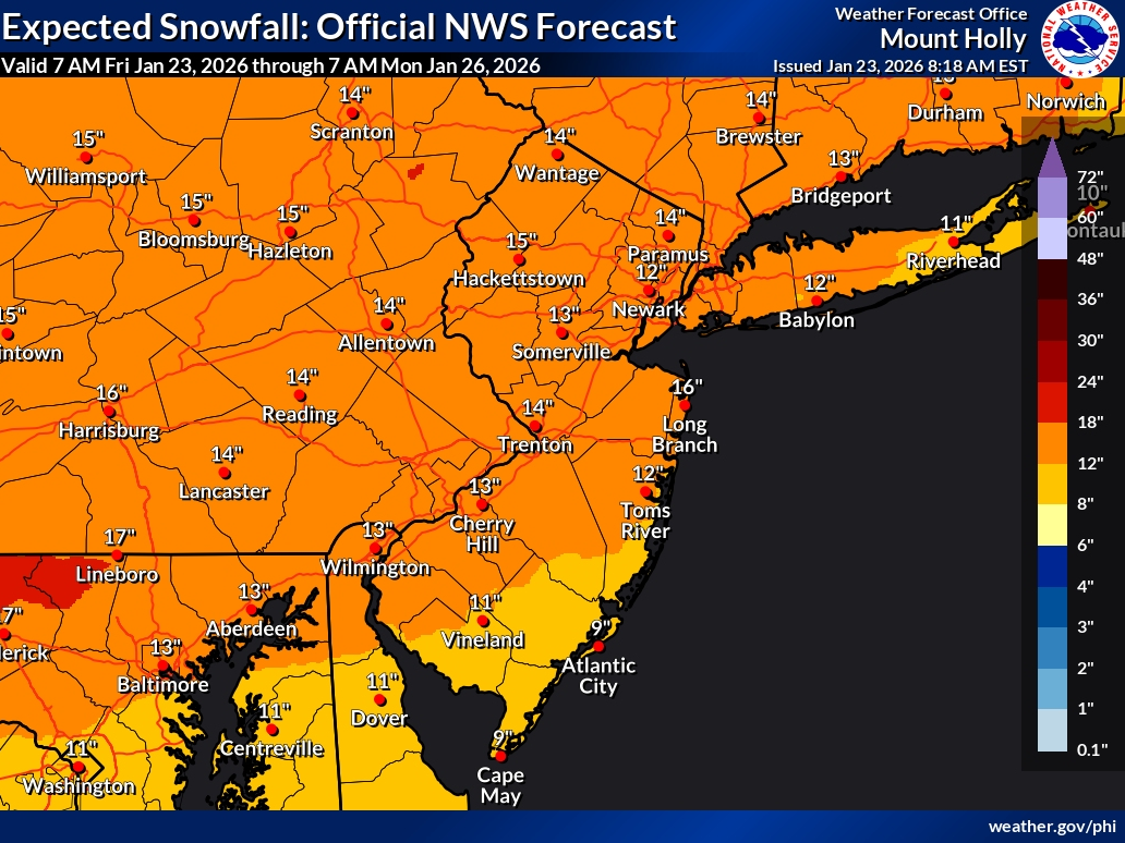
A shift in the weekend storm track has brought down totals from 6 to 16 inches of snow as the threat of ice increases, according to the latest forecast.
Gov. Mikie Sherrill declared a State of Emergency in all 21 counties Friday ahead of the storm, her second so far in office. Her first was on her first day in office, when she declared a State of Emergency over rising electricity costs. Friday is only Sherrill's fourth day in office. Read more: Sherrill Declares State Of Emergency In 1st Day As Governor
"I want to be clear that this is not an average storm," Sherrill said, noting that a storm this intense has not been seen in about a decade. She urged residents to stay home.
Find out what's happening in Across New Jerseyfor free with the latest updates from Patch.
A commercial vehicle travel restriction will be in place on interstate highways.
"Please stay off the roads," Sherrill said. She added not to make any plans for Monday, as "we may still be digging out."
Find out what's happening in Across New Jerseyfor free with the latest updates from Patch.
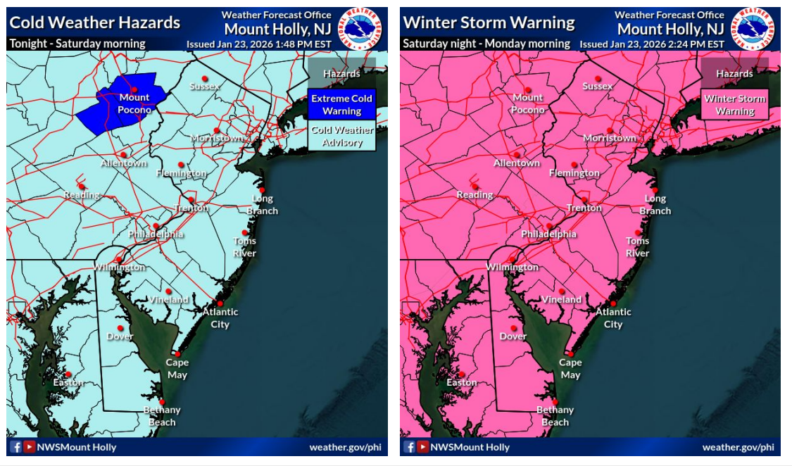
Watches have been upgraded to Winter Storm Warnings across much of the state Friday afternoon. The worst-hit areas could have "nearly impossible" travel conditions, according to the National Weather Service. Only Bergen, Passaic, Hudson, Essex and Union counties, which are covered by the weather service's New York City office, remain under Winter Storm Watches as of Friday afternoon.
Warnings are issued when hazardous events are imminent.
Major impacts, including heavy snow and ice, are expected, the National Weather Service said in a Friday morning briefing.
.jpg)
"Heavy snow and ice accumulation will make travel dangerous or impossible," forecasters said. "Expect widespread road closures and significant delays on major interstates."
The threat of ice has increased, forecasters said, with potentially significant accumulations.
"The combination of heavy snow followed by sleet/freezing rain could result in downed trees and power outages," forecasters said.
.png)
Frigid, dangerously cold temperatures are also forecast during this time.
The storm will move into the area Saturday night, with snow becoming moderate to heavy by daybreak Sunday, according to the National Weather Service.
Some areas, particularly the southeastern portion of the state, will see sleet and rain mixing in Sunday during the day, which could lower snow totals.
"This is not expected to occur until during the day on Sunday, so substantial snow accumulations are still anticipated for these areas prior to any potential changeover," the National Weather Service said.
By Sunday night into Monday morning, cold air will filter back in and precipitation will switch back over to all snow, adding to potential accumulations.
"Breezy northeast winds on Sunday and northwest winds on Monday could lead to some minor blowing and drifting of snow, especially where mixing does not occur and where snow-to- liquid ratios are highest," forecasters said.
Further snow total refinements are expected as the storm draws closer. Check back with Patch for the latest snow updates.
Get more local news delivered straight to your inbox. Sign up for free Patch newsletters and alerts.