Weather
Mother’s Day Weekend Storm In NJ: See Timeline
Thunderstorms, localized flooding and up to 55 mph wind gusts are expected to hit the region through the weekend. Here's the latest.

NEW JERSEY - Garden State residents should plan extra travel time to get to visit mom safely this Mother’s Day, as a coastal storm anticipated to bring thunderstorms, localized flooding and up to 55 mph wind gusts is expected to hit the region through the weekend.
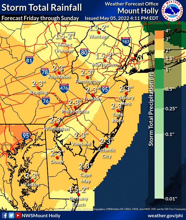
1 to 3 inches of rainfall is expected to slam New Jersey over the course of three days, the National Weather Service said. Chilly conditions, heavy rain and coastal flooding are in the forecast, with storm-force winds expected across most of the state near and north of Atlantic City.
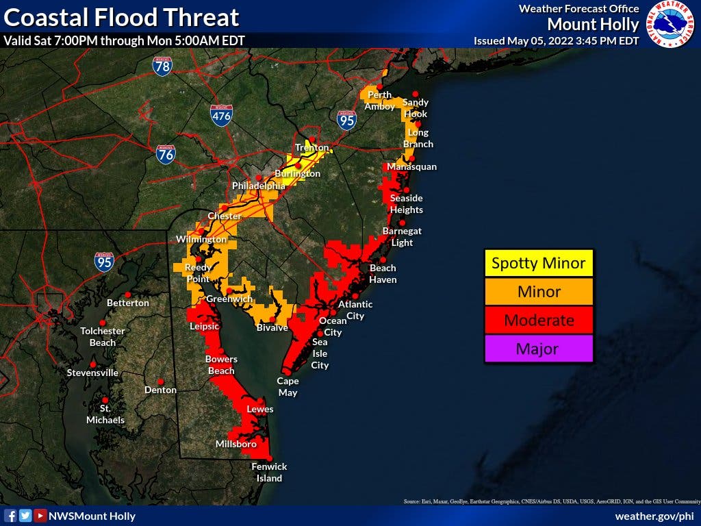
Moderate coastal flooding is possible near Cape May, Atlantic, Burlington and Ocean counties, the National Weather Service said. All four counties are currently under a coastal flood watch through late Saturday night.
Find out what's happening in Across New Jerseyfor free with the latest updates from Patch.
“Up to two feet of inundation above ground level possible in low-lying areas near shorelines and tidal waterways,” the agency said in a coastal flood watch statement on Friday. “At this level, widespread roadway flooding occurs in coastal and bayside communities and along inland tidal waterways. Many roads become impassable. Some damage to vulnerable structures may begin to occur.”
Here’s what’s expected to happen:
Find out what's happening in Across New Jerseyfor free with the latest updates from Patch.
- On Friday, rain is expected to start after 9 a.m., ramping up to periods of heavy rain at times heading into the night. Rainfall should amount to between a tenth and quarter of an inch during the day. Periods of rain will then continue Friday night bringing another three quarters to one inch of rain possible. Winds should remain fairly calm at around 5 to 10 mph in the afternoon, with occasional gusts up to 15-25 mph. A few thunderstorms are possible late in the day into the evening. Temperatures near 60 degrees could drop to about 47 degrees at night.
- Saturday should see periods of rain, with intermittent periods of heavy rain. It’ll be chillier with a high near 50, low near 41 and wind gusts between 30-50 mph, although the strongest winds will be along the coastline. Minor to locally moderate coastal flooding is possible starting with Saturday’s evening high tide.
- Lingering showers should still stick around by Mother’s Day this Sunday. It’ll still be chilly with a high near 54 and a low around 42, though wind gusts should only reach up to 25 mph (with the strongest gusts to be seen along the coast). Some northern areas may see clearing during the daytime. Overall though, “even though rain may taper to drizzle, Mother's Day will not be nice on the beach in the mid-Atlantic with chilly, gusty winds and rough surf," AccuWeather Senior Meteorologist Brett Anderson said. The last rounds of rain should leave the state by 3 a.m. on Monday.
- Coastal flooding and rough surf on the coast could last through Tuesday according to AccuWeather, with strong rip currents and minor beach erosion possible.
Get more local news delivered straight to your inbox. Sign up for free Patch newsletters and alerts.