Weather
NJ Drought Deepens Prompting Calls For More Water Conservation
Three weeks into New Jersey's drought watch, the arid conditions continue to spread throughout the state.

NEW JERSEY — Three weeks into New Jersey's drought watch, the arid conditions continue to spread throughout the state. The trend may continue with little rain in the forecast for the next few days.
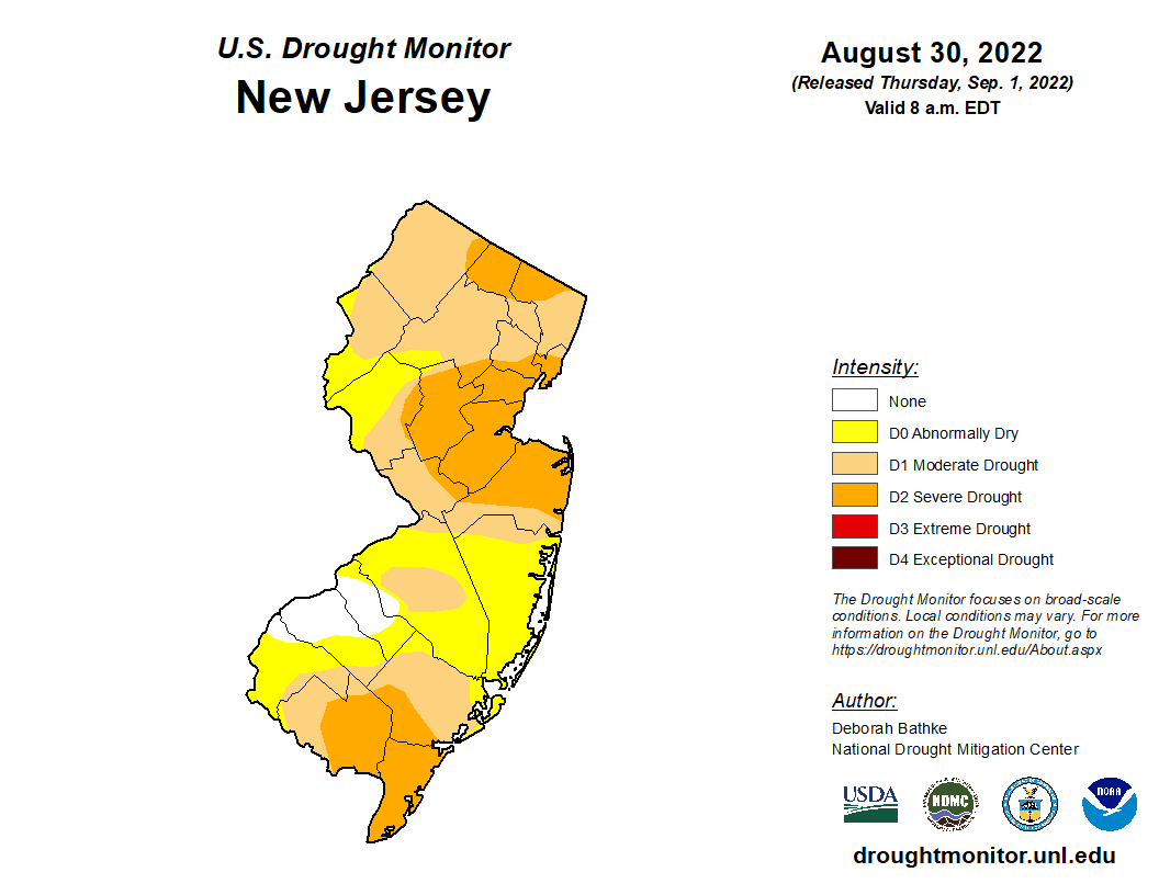
Almost all of North Jersey has entered some level of drought, while the state's southernmost counties entered "severe drought" status. Severe conditions also spread to northern portions of Passaic and Bergen Counties, according to Thursday's map from the U.S. Drought Monitor. Since last week, the severe-drought patch toward the middle of the state expanded into more of Hudson, Essex, Hunderdon, Mercer, Middlesex and Monmouth Counties.
See the latest map below:
Find out what's happening in Across New Jerseyfor free with the latest updates from Patch.
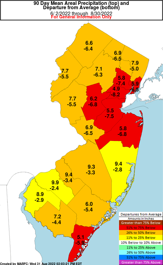
Every New Jersey county has received less rain than usual in the past 90 days. But two of the severe-drought regions fell below half of their normal rainfall totals during that span:
State officials issued a drought watch Aug. 9. The action is meant to raise awareness of the stress on the water supply and encourage voluntary conservation measures. But if the dry conditions don't improve, New Jersey officials could issue a drought warning and then a drought emergency, which could entail mandatory water-conservation measures from the state for the first time in two decades.
Find out what's happening in Across New Jerseyfor free with the latest updates from Patch.
New Jersey last declared a drought emergency and restricted water use in March 2002, leaving it in place until January 2003. The state's climate conditions increase the potential for more frequent and prolonged droughts. New Jersey will experience a greater frequency of intense rain events, and the summer months may see less precipitation overall, according to the 2020 New Jersey Scientific Report on Climate Change.
A severe drought typically entails the following, according to the U.S. Drought Monitor:
- Water quality is poor, groundwater continues declining, irrigation ponds are dry and outdoor water restrictions get implemented.
- Specialty crops are impacted in both yield and fruit size.
- Warnings get issued on outdoor burns, air quality is poor.
- Golf courses conserve water.
- Trees become brittle and susceptible to insects.
- Fish kills occur, as wildlife move to farms for food.
- Producers begin feeding cattle, hay prices become high.
Forecasters expect mostly dry weather in the Mid-Atlantic over the next few days, but rain could fall in parts of New Jersey this Labor Day weekend. The next chances for showers and thunderstorms will arrive with a cold front Sunday afternoon and evening, according to the National Weather Service.
Here's the National Weather Service's latest North Jersey forecast:
- Thursday: Sunny, with a high near 84. Northwest wind around 11 mph, with gusts as high as 23 mph.
- Thursday night: Clear, with a low around 60. North wind 6 to 9 mph.
- Friday: Sunny, with a high near 82. Northeast wind around 6 mph becoming southeast in the afternoon.
- Friday night: Partly cloudy, with a low around 65. Southeast wind 3 to 7 mph.
- Saturday: Partly sunny, with a high near 84. Calm wind becoming southeast 5 to 9 mph in the afternoon.
- Saturday night: Partly cloudy, with a low around 69.
- Sunday: A 40 percent chance of showers and thunderstorms after 2 p.m. Partly sunny, with a high near 89.
- Sunday night: A chance of showers and thunderstorms before 8 p.m., then a chance of showers between 8 p.m. and 2 a.m. Mostly cloudy, with a low around 69. Chance of precipitation is 30 percent.
- Labor Day: A chance of showers between 8 a.m. and 2 p.m., then a chance of showers and thunderstorms after 2 p.m. Partly sunny, with a high near 81. Chance of precipitation is 50 percent.
- Monday night: A chance of showers and thunderstorms. Mostly cloudy, with a low around 68. Chance of precipitation is 30 percent.
Here's the agency's latest South Jersey forecast:
- Thursday: Sunny, with a high near 87. West wind 10 to 15 mph.
- Thursday night: Clear, with a low around 58. Northwest wind around 5 mph becoming northeast after midnight.
- Friday: Sunny, with a high near 84. Northeast wind around 5 mph.
- Friday night: Partly cloudy, with a low around 61. East wind around 5 mph becoming calm in the evening.
- Saturday: Partly sunny, with a high near 85. Northeast wind around 5 mph becoming southeast in the afternoon.
- Saturday night: Mostly cloudy, with a low around 67.
- Sunday: Partly sunny, with a high near 89.
- Sunday night: A chance of showers and thunderstorms between 8 p.m. and 2 a.m. Mostly cloudy, with a low around 66. Chance of precipitation is 30 percent.
- Labor Day: A chance of showers and thunderstorms after 2 p.m. Partly sunny, with a high near 85. Chance of precipitation is 40 percent.
- Monday night: A chance of showers and thunderstorms before 8 p.m., then a chance of showers between 8 p.m. and 2 a.m. Mostly cloudy, with a low around 66. Chance of precipitation is 30 percent.
Get more local news delivered straight to your inbox. Sign up for free Patch newsletters and alerts.