Weather
NJ Weather: Rain Friday, Then Warm Weekend Ahead
After the rain moves through, forecasters say Saturday and Sunday appear to be good days for outdoor activities around New Jersey.


NEW JERSEY — Rain showers will start the weekend with a risk of flooding in New Jersey, but the moisture will give way to a warm first weekend in May according to forecasters.
AccuWeather.com predicts showers Friday, but otherwise forecasts a seasonable spring weekend with temperatures 20-30 degrees above where they were earlier this week.
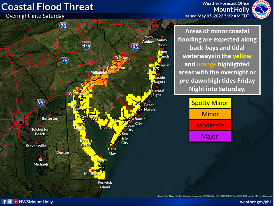
Showers are expected until early Friday evening in the north and central parts of New Jersey. There is also minor threat of coastal flooding for communities along back bays and tidal waterways on the Delaware River in New Jersey.
Find out what's happening in Across New Jerseyfor free with the latest updates from Patch.
Spotty coastal flooding is also possible along the Jersey Shore into Saturday, said the National Weather Service.
“This is due to the combination of the high astronomical tides, and otherwise higher than usual water levels,” the NWS said.
Find out what's happening in Across New Jerseyfor free with the latest updates from Patch.
After the rain moves through, Saturday and Sunday appear to be good days for outdoor activities around New Jersey.
“Saturday should turn out to be the most pleasant day we've seen in at least a couple of weeks,” said the National Weather Service in Mount Holly, adding that Sunday also “looks seasonably warm.”
There is a chance for spotty showers in the region on Sunday, but forecasters say it will not largely impact New Jersey.
.jpg)
A jet stream pattern called an Omega block (for its shape, like the Greek letter Ω) locked in cold, unsettled conditions in the Northeastern states earlier this week, AccuWeather said.
As the Omega block breaks down in the coming days, the chilly temperatures in the Northeast will ease, said AccuWeather Long-Range Meteorologist Brandon Buckingham.
"In the Northeast, highs in the 40s and 50s that have been felt for much of the week will be swapped out for highs in the 60s and 70s in many areas by the weekend," Buckingham said.
Here is the latest weekend forecast the National Weather Service around New Jersey:
North Jersey
Friday
Scattered showers, mainly after 4pm. Partly sunny, with a high near 62. East wind around 5 mph. Chance of precipitation is 30 percent.
Friday Night
Isolated showers before 11pm. Partly cloudy, with a low around 45. South wind around 5 mph becoming calm in the evening. Chance of precipitation is 20 percent.
Saturday
Sunny, with a high near 70. Northwest wind 3 to 7 mph.
Saturday Night
Mostly clear, with a low around 48. Northwest wind 3 to 5 mph.
Sunday
Mostly sunny, with a high near 74. West wind 3 to 8 mph.
Sunday Night
Mostly cloudy, with a low around 54.
Central Jersey
Friday
Scattered showers, mainly after 2pm. Partly sunny, with a high near 62. Northeast wind around 5 mph. Chance of precipitation is 30 percent. New precipitation amounts of less than a tenth of an inch possible.
Friday Night
Scattered showers, mainly before 8pm. Patchy fog after 3am. Otherwise, mostly cloudy, with a low around 42. Southeast wind around 5 mph becoming calm. Chance of precipitation is 30 percent. New precipitation amounts of less than a tenth of an inch possible.
Saturday
Patchy fog before 7am. Otherwise, mostly sunny, with a high near 69. Northwest wind around 5 mph.
Saturday Night
Mostly clear, with a low around 46. Calm wind becoming west around 5 mph.
Sunday
Mostly sunny, with a high near 75. West wind, 5 to 10 mph.
Sunday Night
A slight chance of showers. Mostly cloudy, with a low around 54. Chance of precipitation is 20 percent.
South Jersey
Friday
Scattered showers, mainly after 2pm. Partly sunny, with a high near 61. Northeast wind 5 to 10 mph becoming east in the afternoon. Chance of precipitation is 30 percent. New precipitation amounts of less than a tenth of an inch possible.
Friday Night
Patchy fog after 3am. Otherwise, mostly cloudy, with a low around 48. Southeast wind around 5 mph becoming calm after midnight.
Saturday
Areas of fog before 7am. Otherwise, mostly sunny, with a high near 65. Light and variable wind becoming south 5 to 10 mph in the afternoon.
Saturday Night
Mostly clear, with a low around 52. West wind 5 to 10 mph.
Sunday
Mostly sunny, with a high near 70. West wind 5 to 10 mph becoming south in the afternoon.
Sunday Night
A slight chance of showers. Mostly cloudy, with a low around 55. Chance of precipitation is 20 percent.
Get more local news delivered straight to your inbox. Sign up for free Patch newsletters and alerts.