Weather
Snow Becoming More Likely For Weekend Winter Storm Targeting NJ
There is still uncertainty regarding Sunday's storm, but models show potentially impactful snow in New Jersey.

The first snowfall total projections for a possible winter storm Sunday have been released as forecasters being to get more clarity on outcomes.
"There remains a large amount of uncertainty as to how impactful this system will be to the local region," National Weather Service forecasters warned.
As of Thursday afternoon, forecasters said that the outcome may be something "more in the middle," which would mean an intensifying storm offshore but not one that moves as quick as some of the guidance says. No matter the outcome, wintry precipitation is likely. The question is whether it will be heavy or light snow.
Find out what's happening in Across New Jerseyfor free with the latest updates from Patch.
"Even a weaker storm will still result in an increasing northeasterly low-level wind into our coastal areas especially," National Weather Service forecasters said. "This would increase the risk for at least some coastal flooding Sunday into Monday, and this would increase even more if the storm ends up being stronger (i.e. stronger onshore winds)."
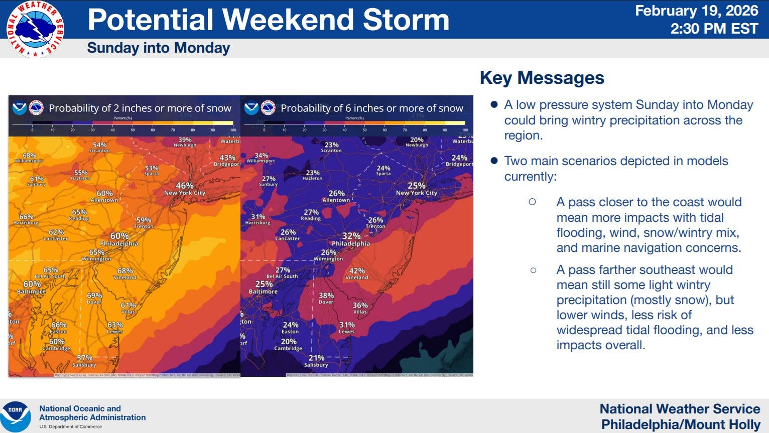
"If the system is much stronger and closer to the coast, more intense dynamics would lead to more snow (heavier precipitation rates), while weaker and farther offshore solutions would favor lighter snow amounts with even precipitation potentially starting as rain," National Weather Service forecasters said.
Find out what's happening in Across New Jerseyfor free with the latest updates from Patch.
AccuWeather forecasters released a map showing most of New Jersey getting 1 to 3 inches, with the far southern counties getting 3 to 6 inches.
.png)
“The exact track of this storm, along with how quickly it strengthens, will determine how much snow falls in the mid-Atlantic and Northeast,” AccuWeather Vice President of Forecasting Operations Dan DePodwin said. “The supply of cold air is limited, and that could also affect snowfall totals.”
.png)
“The critical question for heavy versus light snow along I-95 is the track of the coastal storm,” DePodwin said. “That track will depend on how quickly the storm intensifies.”
It could be cold enough for most of the precipitation to fall as snow, but that could melt on impact with pavement.
“During the day Sunday and Monday, when snow is not falling heavily, highways and city streets can be just wet or slushy in spots due to temperatures near freezing combined with the higher sun angle in late February,” DePodwin explained. “However, there will be periods when snowfall rates are heavy enough to overcome marginal temperatures and sunlight, especially at night.”
Patch will share updates as the forecaster becomes clearer.
Get more local news delivered straight to your inbox. Sign up for free Patch newsletters and alerts.