Weather
Thunderstorms, Downpours, Damaging Gusts Could Hit NJ: See Timeline
North Jersey has the highest risk of severe thunderstorms with heavy winds. Here's the latest forecast.

NEW JERSEY — A string of severe thunderstorms that bring downpours and damaging gusts could hit New Jersey later Friday, according to forecasters. The potentially severe weather would occur from the afternoon to the evening, primarily impacting North Jersey, AccuWeather predicts.
The Northeastern thunderstorms could include hail, isolated tornadoes and gusts of 50-60 mph, with a max of 70 mph. But fortunately for the region, AccuWeather only projects a "slight" risk of severe weather. Thunderstorms, however, are likely to develop in North Jersey, according to Brett Anderson, the weather network's senior meteorologist.
"The first area will likely form where the air heats up quickly from southern New England to New Jersey and the eastern half of Pennsylvania during Friday afternoon," Anderson said.
Find out what's happening in Across New Jerseyfor free with the latest updates from Patch.
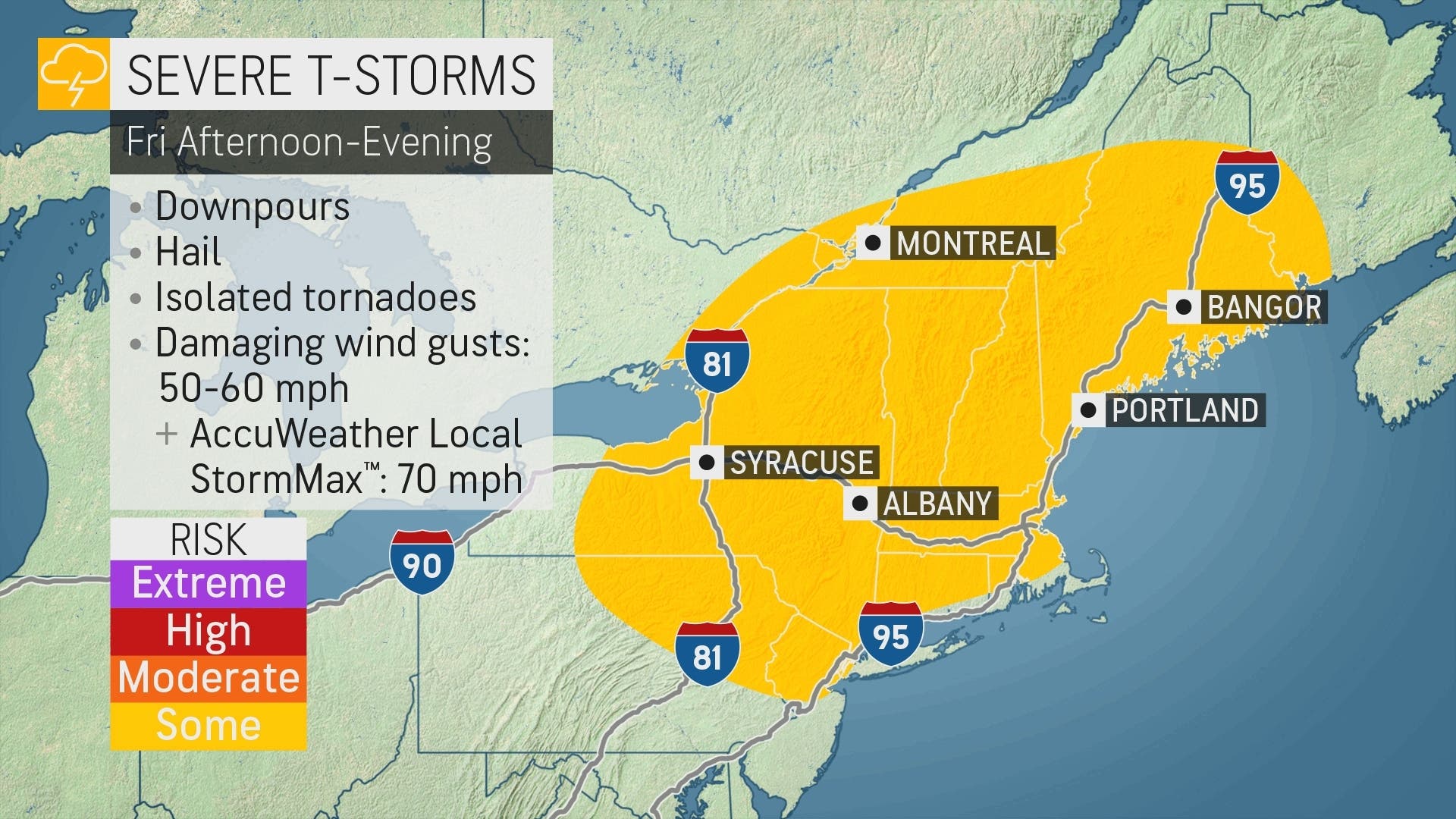
The National Weather Service issued a hazardous weather outlook for northeastern New Jersey, warning of the potential for scattered severe thunderstorms with damaging winds into Friday night. The hazardous weather outlook includes Bergen, Passaic, Essex, Union and Hudson Counties.
Flash floods are less likely because of the storms' spotty and fast-moving nature, but they may still cause travel issues as they approach the busy Interstate 95 corridor, according to AccuWeather.
Find out what's happening in Across New Jerseyfor free with the latest updates from Patch.
The storms could benefit some areas with New Jersey in the midst of a drought watch. Read more: Drought Expands In NJ Despite Rain, Floods This Week
"Most of this rainfall from Friday's storms should be beneficial," Anderson said. "However, as is often the case with summertime thunderstorm activity, some areas may miss out, while other locations may get a 20-minute deluge."
New Jersey has a clearer forecast over the weekend but could still see some stormy weather, according to the National Weather Service.
Here's the National Weather Service's latest North Jersey forecast:
- Friday: A 40 percent chance of showers and thunderstorms. Partly sunny, with a high near 90. Southwest wind 5 to 10 mph, with gusts as high as 21 mph.
- Friday night: A 20 percent chance of showers and thunderstorms before 10 p.m. Partly cloudy, with a low around 71. West wind 3 to 6 mph.
- Saturday: Mostly sunny, with a high near 86. North wind around 6 mph.
- Saturday night: Partly cloudy, with a low around 70. East wind 3 to 6 mph.
- Sunday: A 20 percent chance of showers and thunderstorms after 2 p.m. Partly sunny, with a high near 84. Southeast wind 6 to 9 mph.
- Sunday night: Partly cloudy, with a low around 71.
Here's the agency's latest South Jersey forecast:
- Friday: Scattered showers and thunderstorms, mainly after 3 p.m. Sunny, with a high near 91. Southwest wind 5 to 10 mph. Chance of precipitation is 30 percent. New rainfall amounts of less than a tenth of an inch, except higher amounts possible in thunderstorms.
- Friday night: Scattered showers and thunderstorms, mainly before 8 p.m. Partly cloudy, with a low around 71. South wind around 5 mph. Chance of precipitation is 30 percent. New precipitation amounts of less than a tenth of an inch, except higher amounts possible in thunderstorms.
- Saturday: A chance of showers and thunderstorms after 2 p.m. Mostly sunny, with a high near 90. Northwest wind around 5 mph becoming calm. Chance of precipitation is 40 percent. New rainfall amounts between a tenth and quarter of an inch, except higher amounts possible in thunderstorms.
- Saturday night: A chance of showers and thunderstorms before 8 p.m. Partly cloudy, with a low around 68. Southeast wind around 5 mph becoming calm. Chance of precipitation is 30 percent. New precipitation amounts of less than a tenth of an inch, except higher amounts possible in thunderstorms.
- Sunday: A slight chance of showers and thunderstorms after 2 p.m. Mostly sunny, with a high near 88. East wind 5 to 10 mph becoming southeast in the afternoon. Chance of precipitation is 20 percent.
- Sunday night: Partly cloudy, with a low around 69.
Get more local news delivered straight to your inbox. Sign up for free Patch newsletters and alerts.