Weather
Triple-Digit Heat Precedes Severe Storms Across NJ
It'll feel like more than 100 degrees in the Garden State Wednesday, and as the day goes on, we could get blasted by severe thunderstorms.

NEW JERSEY — Wednesday's weather will prove that summer isn't quite over yet as heat and humidity return to the Garden State, before potential severe storms drench the state.
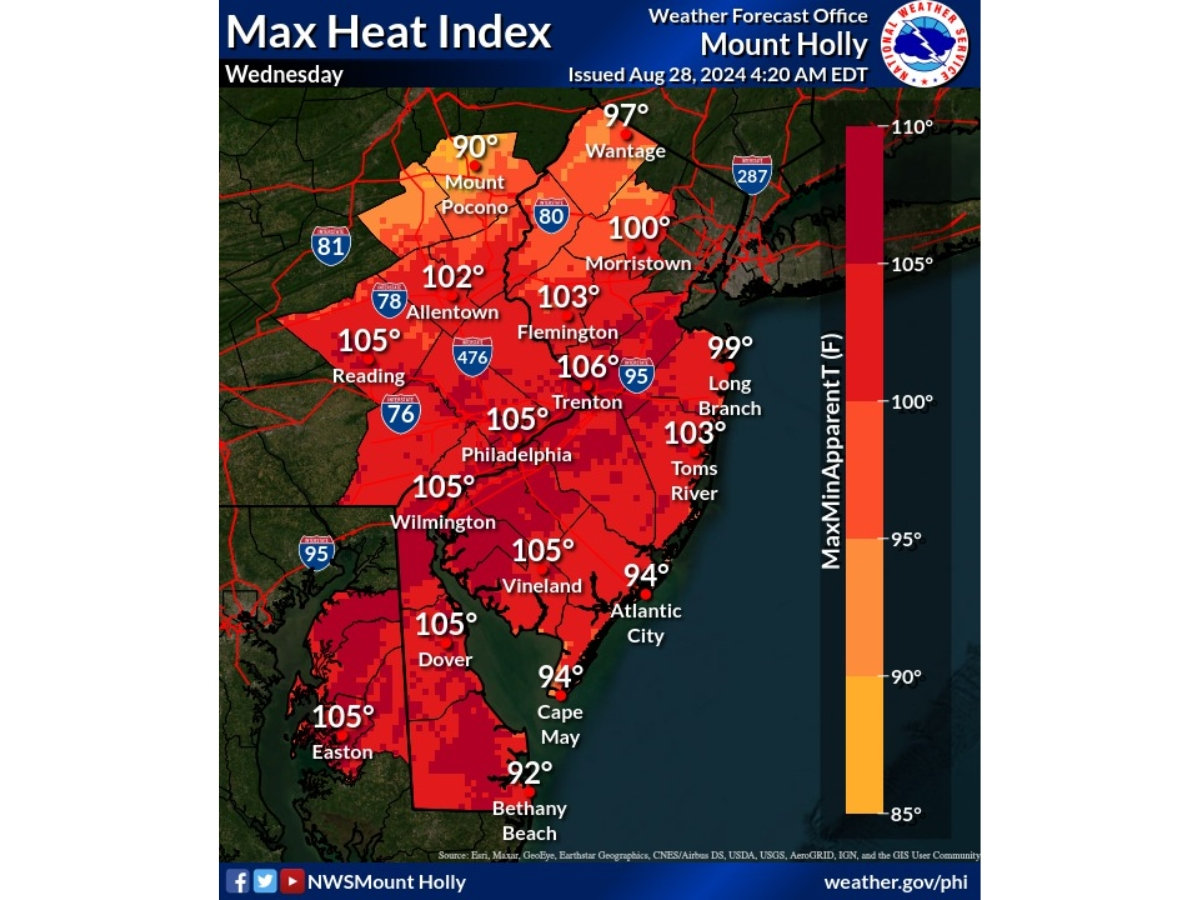
The heat index will reach triple-digits Wednesday, according to the National Weather Service, with much of the state under a heat advisory from 11 a.m. through 8 p.m. this evening. Parts of Central and South Jersey are under an excessive heat warning. In some areas, it'll feel like up to 106 degrees, the National Weather Service said.
"The other main concern today is the potential for thunderstorms, some could possibly be severe," the National Weather Service said.
Find out what's happening in Across New Jerseyfor free with the latest updates from Patch.
There's two time periods storms could fire off, forecasters say. First is mid-to-late afternoon, though forecasters are unsure if we will see anything then.
The more likely option, according to the National Weather Service, is this evening into overnight. But factors are still uncertain here so it could be mostly showers with isolated thunderstorms, forecasters say.
Find out what's happening in Across New Jerseyfor free with the latest updates from Patch.
The severe threat is "very conditional," the National Weather Service said, though damaging winds and small hail are both possible.
A cooldown will hit Thursday and Friday, with further chances of thunderstorms.
Here's the latest forecast.
North Jersey
Wednesday: A 30 percent chance of showers and thunderstorms after 2pm. Mostly sunny, with a high near 95. Heat index values as high as 102. West wind 8 to 10 mph.
Wednesday Night: A 30 percent chance of showers and thunderstorms, mainly before 2am. Mostly cloudy, with a low around 67. North wind 7 to 9 mph.
Thursday: A slight chance of showers and thunderstorms before 8am, then a slight chance of showers after 2pm. Partly sunny, with a high near 78. Northeast wind 8 to 10 mph. Chance of precipitation is 20%.
Thursday Night: A slight chance of showers and thunderstorms. Partly cloudy, with a low around 64. East wind around 7 mph. Chance of precipitation is 20%.
Friday: A 20 percent chance of showers. Mostly sunny, with a high near 76. Southeast wind 6 to 10 mph.
Friday Night: Partly cloudy, with a low around 64.
Central Jersey
Wednesday: Mostly sunny, with a high near 96. Heat index values as high as 105. West wind 5 to 10 mph.
Wednesday Night: A chance of showers and thunderstorms, mainly between 7pm and 5am. Mostly cloudy, with a low around 67. Northeast wind around 5 mph. Chance of precipitation is 30%. New rainfall amounts of less than a tenth of an inch, except higher amounts possible in thunderstorms.
Thursday: A slight chance of showers before 7am, then a slight chance of showers after 2pm. Mostly cloudy, with a high near 77. East wind around 10 mph. Chance of precipitation is 20%.
Thursday Night: A chance of showers and thunderstorms before 11pm, then a chance of showers between 11pm and 5am, then a chance of showers and thunderstorms after 5am. Mostly cloudy, with a low around 63. East wind around 5 mph. Chance of precipitation is 30%. New rainfall amounts of less than a tenth of an inch, except higher amounts possible in thunderstorms.
Friday: A slight chance of showers and thunderstorms. Partly sunny, with a high near 77. East wind around 5 mph. Chance of precipitation is 20%.
Friday Night: A slight chance of showers after 2am. Mostly cloudy, with a low around 65. Chance of precipitation is 20%.
South Jersey
Wednesday: Mostly sunny, with a high near 96. Heat index values as high as 104. West wind 5 to 10 mph.
Wednesday Night: A chance of showers and thunderstorms, mainly between 8pm and 5am. Mostly cloudy, with a low around 69. Calm wind becoming northeast around 5 mph after midnight. Chance of precipitation is 40%. New rainfall amounts between a tenth and quarter of an inch, except higher amounts possible in thunderstorms.
Thursday: A slight chance of showers before 7am, then a slight chance of showers after 2pm. Partly sunny, with a high near 78. East wind around 5 mph. Chance of precipitation is 20%.
Thursday Night: A chance of showers, with thunderstorms also possible after 2am. Mostly cloudy, with a low around 63. East wind around 5 mph. Chance of precipitation is 30%. New rainfall amounts between a tenth and quarter of an inch, except higher amounts possible in thunderstorms.
Friday: A chance of showers and thunderstorms before 2pm, then a slight chance of showers. Partly sunny, with a high near 77. East wind around 5 mph. Chance of precipitation is 30%. New rainfall amounts of less than a tenth of an inch, except higher amounts possible in thunderstorms.
Friday Night: Mostly cloudy, with a low around 64.
Get more local news delivered straight to your inbox. Sign up for free Patch newsletters and alerts.


