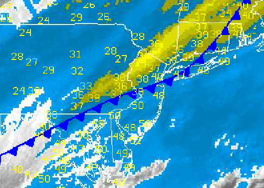
A powerful Arctic cold front is introducing the first bite of winter conditions to the Philadelphia and New York City metropolitan areas as strong northwesterly winds drive an arctic air mass into the region. The high temperatures for today have come and gone already this morning with temperatures ahead of the cold front in the 40's and 50's crashing into the 30's and 20's.
The cold front will clear the coast by later this morning as waves of rain showers change over to snow showers as cold air invades. A dusting of snow is possible in some locations, especially over the interior, where temperatures have fallen below freezing already. Otherwise, the main impact from today's weather will be the strong northwesterly winds at 10 to 20 mph which will make temperatures fall like the upper 20's to lower 30's by this afternoon. Temperatures this afternoon will hold in the mid to upper 30's over the interior and upper 30's to lower 40's along the coast.
High pressure will take hold tonight on through tomorrow with scattered cloud cover and winds from the northwest at 5 to 15 mph. Temperatures will be well below normal. Low temperatures will range from the mid to upper 20's along the coast and upper 10's to lower 20's over the interior. High temperatures will struggle in the upper 30's to lower 40's over the interior and lower to mid 40's along the coast.
Find out what's happening in Freeholdfor free with the latest updates from Patch.
High pressure will shift off the coast Thursday on through Sunday with scattered cloud cover and moderating temperatures back to near normal levels. Temperatures on Thursday and Friday will range from the upper 20's to mid 30's for lows and upper 40's to lower 50's for highs. Temperatures on Saturday and Sunday will range from the mid to upper 40's for lows and mid to upper 50's for highs.
On Monday, a warm front will move through the region with scattered showers and a strong southwesterly wind at 10 to 20 mph. Temperatures will rise to above normal levels with lows in the upper 40's to lower 50's and highs in the upper 50's to lower 60's.


