
An Arctic chill has settled into the Philadelphia and New York City metropolitan areas just in time for the end of 2013 and start of 2014. While many will be celebrating in the new year, a storm will be gathering in the Gulf of Mexico to bring 2014 the first snow storm of the new year by Thursday morning.
Today through tomorrow, a series of weak Arctic cold front boundaries will drop south through the Philadelphia and New York City metropolitan areas. Scattered cloud cover can be expected but a few flurries or snow showers will still remain a threat. Winds will be from the northwest and north at 5 to 15 mph. Temperatures this afternoon will rise into the lower to mid 30's. Tonight, temperatures will crash into the mid to upper 10's over the interior and lower to mid 20's along the coast. High temperatures tomorrow will rebound into the mid to upper 20's over the interior and upper 20's to lower 30's along the coast.
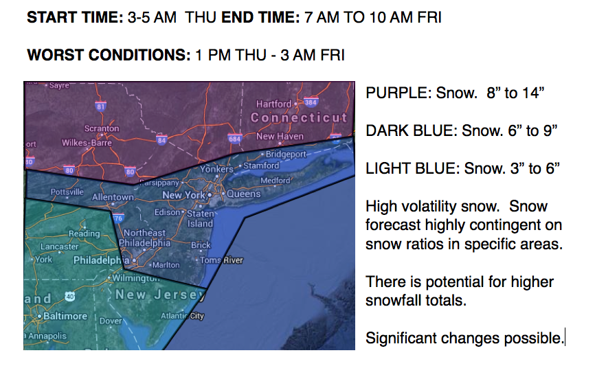
An area of low pressure will organize in the Gulf of Mexico and track towards the Virginia coastal waters by Thursday night. This area of low pressure will produce widespread light to moderate snowfall with a few areas of heavy snowfall possible. The snow will continue on through Thursday night and into Friday morning with significant snowfall accumulations possible. Winds will back from the northeast to northwest at 10 to 20 mph with gusts up to 40 mph at times. Temperatures over the interior will range from lower to mid 20's on Thursday and then fall into the single digits and teens on Friday. Temperatures along the coast will range from the upper 20's to mid 30's on Thursday and fall into the lower to mid 10's on Friday.
Find out what's happening in Freeholdfor free with the latest updates from Patch.
High pressure will take control Friday night into Saturday with scattered cloud cover expected. Temperatures will remain well below normal through the period. Low temperatures will be in the single digits throughout the region with high temperatures in the upper 10's to lower 20's over the interior and mid to upper 20's along the coast.
Find out what's happening in Freeholdfor free with the latest updates from Patch.
An area of low pressure will approach on Sunday afternoon through Monday with periods of snow, sleet, and rain. Temperatures on Sunday will range from the upper 10's to mid 20's for lows and mid to upper 30's for highs. Temperatures on Monday will range from the mid 20's to lower 30's for lows and lower to mid 30's for highs.


