A weak warm front is moving through the Philadelphia and New York City metropolitan areas this morning with scattered showers and broken to overcast cloud cover. Temperatures will warm back to normal with highs in the lower to mid 50's. However, much colder and stormier times are ahead just in time for Thanksgiving.
Today, a few lingering showers will move through the Philadelphia and New York City metropolitan areas today with otherwise broken cloud cover. Winds will be from the southwest at 5 to 15 mph, increasing to 10 to 20 mph this evening. Temperatures will rise into the upper 40's to lower 50's over the interior and lower to mid 50's along the coast for afternoon highs.
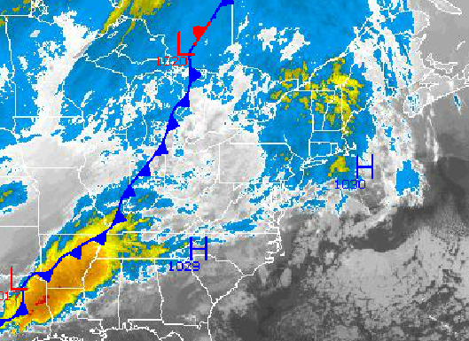
A strong cold front will move through the northern Mid Atlantic tonight into tomorrow morning with periods of showers. The showers will be capable of heavy downpours at times. The showers will exit by mid morning with clearing skies in the late morning hours through the afternoon. Winds will veer to the northwest at 10 to 20 mph with gusts up to 30 mph at times. Temperatures will range from the mid to upper 30's for lows and mid to upper 40's for highs.
Find out what's happening in Freeholdfor free with the latest updates from Patch.
Arctic high pressure will be in control tomorrow night through Monday with clear skies and very windy conditions. Winds will be from the northwest at 10 to 20 mph with gusts over 30 mph. Temperatures will be well below normal through the forecast period. On Sunday temperatures will range from the mid to upper 20's for lows and lower to mid 30's for highs. On Monday, temperatures will range from the upper 10's to lower 20's for lows and lower to mid 30's for highs. Wind chills will be in the 20's and 30's through the forecast period in the afternoon hours.
A cold front will follow on Tuesday with scattered rain and snow showers becoming widespread towards evening. Temperatures will moderate ahead of the cold front with lows in the mid to upper 20's and highs in the mid to upper 40's.
Find out what's happening in Freeholdfor free with the latest updates from Patch.
An area of low pressure will approach from the Gulf of Mexico and lift through the New Jersey coastal waters on Wednesday. A variety of impacts can be expected with this storm depending on location and elevation. Significant travel impacts can be expected due to the heavy precipitation leading to poor visibility and increasing winds veering from the east to the northwest.
Along the coast and in the major cities, periods of moderate to heavy rain can be expected mixing with sleet and snow at times. No accumulation of snow or ice is expected but this cold rain will chill to the bone. Temperatures will range from the upper 30's to mid 40's for highs and then fall into the lower to mid 30's by the late evening. The rain may end as snow showers.
Over the interior, the forecast is far more treacherous. Rain may begin on the onset but for elevations above 1,000 feet, the rain will mix with and change over to snow. Accumulating snowfall is possible with this storm. However, the exact track and size of the storm will determine the snowfall amount potential for this storm, which is uncertain at this time. Temperatures will range from the lower to mid 30's at the height of the storm before falling into the upper 20's to lower 30's by the evening. Significant travel impacts are expected on Wednesday regardless of the amount of snowfall.
By Thanksgiving Thursday, the storm will exit into the Atlantic with clearing skies expected. However, strong northwesterly winds will be present at 15 to 30 mph. Temperatures will be well below normal with lows in the mid 20's to lower 30's and highs in the mid 30's.


