The reprieve from the harsh winter weather is coming to an end this weekend with a slow and steady drop in temperatures through this week. The Philadelphia and New York City metropolitan areas will start the week above normal and end the weekend with below normal temperatures. The threat for rain and later snow showers will follow the progression down to below normal temperatures.
Today, clouds will gradually increase as winds back to the southwest at 5 to 15 mph. Moisture from the Gulf Coast will steadily stream into the region leading to overcast skies by tonight. Temperatures will rise not the upper 40's to lower 50's over the interior and lower to mid 50's along the coast.
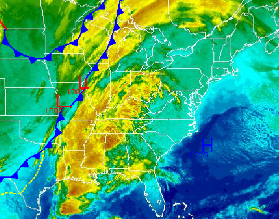
A strong cold front with a wave of low pressure will move through the region tomorrow on through Wednesday morning. Scattered showers will develop tomorrow morning and spread throughout the region by the afternoon. As the cold front passes through the region, an area of low pressure will ride along the cold front bringing periods of rain, possibly ending as snow tomorrow night into Wednesday morning. No snowfall accumulation is expected along the coast, however accumulations of up to 2" will be possible for elevations above 1,000 feet. Temperatures on Tuesday will range from the upper 30's to lower 40's for lows and upper 40's to lower 50's for highs. Temperatures by Wednesday morning will fall into the lower to mid 30's.
Find out what's happening in Freeholdfor free with the latest updates from Patch.
A weak area of high pressure will take hold Wednesday afternoon through Thursday morning with scattered cloud cover. Another area of low pressure will develop along the North Carolina coast and lift northeast towards the New Jersey coastal waters. At this time the track of this low pressure system will be far enough east to only produce periods of snow showers and some light snowfall accumulation on Thursday night into Friday morning. The best potential for snowfall accumulation will be focused along the coast. Temperatures on Wednesday afternoon will rise into the lower to mid 40's for highs. Temperatures on Thursday will range from the mid to upper 20's for lows and upper 30's to lower 40's for highs. Temperatures by Friday morning will fall into the mid to upper 20's over the interior and upper 20's to lower 30's along the coast for lows.
High pressure will briefly take hold for Friday afternoon through Saturday afternoon with scattered cloud cover expected. Another area of low pressure will bring the threat for snow showers and a period of light snow Saturday night into Sunday morning. Temperatures on Friday will rise into the upper 30's to lower 40's over the interior and lower to mid 40's along the coast for highs. Temperatures on Saturday will range from the upper 10's to mid 20's for lows and upper 20's to mid 30's for highs. Temperatures on Sunday will range from the upper 10's to mid 20's for lows and mid 20's to lower 30's for highs. The warmest conditions will be focused in urban areas and along the immediate coast.


