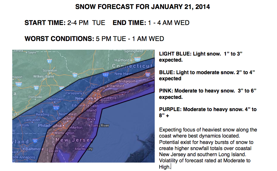

A strong Alberta Clipper diving southeast from the Northern Plains to the Mid Atlantic Coast by tomorrow afternoon will produce periods of moderate to heavy snow over the Philadelphia and New York City metropolitan areas. This low pressure system will mark the establishment of Arctic air over the region that is not expected to leave for the rest of the week.
Tranquil conditions can be expected today as the cold front will remain to the west of the region. Winds will remain from the west at 5 to 15 mph. Temperatures will rise to above normal levels for one more day with highs in the mid to upper 30's over northeastern Pennsylvania, lower to mid 40's over the rest of the interior, and mid to upper 40's along the coast and in urban locations.
Tonight, clouds will increase with snow showers developing towards morning. Winds will veer to the north at 10 to 20 mph as temperatures crash into the lower to mid 10's over the interior and upper 10's to lower 20's along the coast.
Find out what's happening in Freeholdfor free with the latest updates from Patch.
As the low pressure system rapidly intensifies off the New Jersey coast tomorrow evening, snow will become widespread and heavy at times. The heaviest snowfall is expected along the coast with accumulations over six inches possible. Winds will be from the north-northwest at 15 to 30 mph with higher gusts. Temperatures will rise into the upper 10's over the interior and lower to mid 20's along the coast before falling into the single digits and 10's in the evening hours. Expected snowfall accumulations can be found below.
Find out what's happening in Freeholdfor free with the latest updates from Patch.
The storm will exit by Wednesday morning with lingering snow showers followed by clearing skies. Another disturbance will bring the threat for snow showers on Thursday with minor to moderate snowfall accumulations possible. Scattered clouds can be expected on Friday. Temperatures will range from the single digits to lower 10's for lows. High temperatures on Wednesday will range from the lower to mid 10's and then upper 10's to lower 20's for Thursday and Friday.
Another series of disturbances will produce snow showers on Saturday and Sunday with some accumulation possible. Temperatures will range from the mid 10's to lower 20's for lows and lower to mid 30's for highs.


