A disturbance will move through the Philadelphia and New York City metropolitan areas this morning with a period of light snow and snow showers that will linger into the afternoon. A more robust storm is expected on Sunday night, however mostly rain is expected with this low pressure system. Arctic air makes a sustained return by the start of the new year with temperatures falling well below normal.
For this morning, periods of light snow can be expected over the Philadelphia and New York City metropolitan areas as a Polar disturbance moves through the region. The light snow will produce accumulations of a trace to as much as an inch before departing in the afternoon hours. Winds will be from the west at 5 to 10 mph. Temperatures will rise into the mid 30's over the interior and upper 30's to lower 40's in the afternoon.
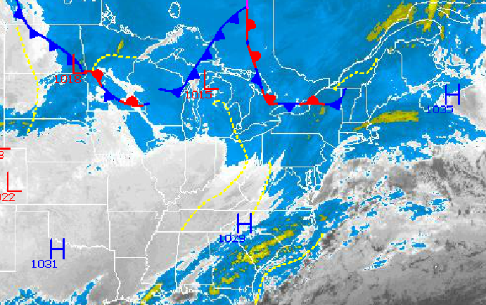
High pressure will be in control tonight on through Saturday with tranquil weather conditions. The high pressure system will shift off the East coast by Saturday leading to winds backing to the southwest and allowing for some moderation in the temperatures. Low temperatures tonight will range from the mid to upper 10's over the interior and lower to mid 20's along the coast. High temperatures tomorrow will range from the mid to upper 30's over the interior and upper 30's to lower 40's along the coast. On Saturday, temperatures will range from the mid 20's to lower 30's for lows and mid to upper 40's for highs.
Find out what's happening in Freeholdfor free with the latest updates from Patch.
An area of low pressure will approach from the Tennessee River Valley on Sunday with increasing clouds followed by periods of rain Sunday evening into Monday morning. The air mass will be warm enough to support mostly rain throughout the entire northern Mid Atlantic, even the interior. The rain will mix over to snow at the end over northeastern Pennsylvania as the storm departs with little if any accumulation of snow expected. Temperatures on Sunday will range from the lower to mid 30's for lows and mid to upper 40's for highs. Temperatures on Monday will feature morning highs in the mid to upper 40's followed by falling temperatures through the day into the 30's.
Arctic high pressure will take hold Tuesday and Wednesday with scattered clouds and the potential for a few flurries. Temperatures will average below normal for both days. On Tuesday temperatures will range from the mid to upper 20's for lows and upper 20's to lower 30's for highs. On Wednesday, temperatures will range from the mid 10's to lower 20's for lows and upper 20's to mid 30's for highs.


