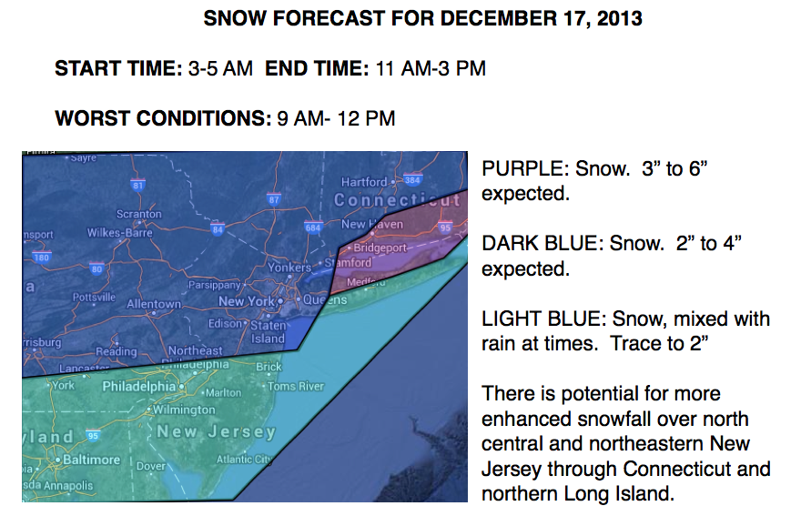

An area of low pressure will redevelop off the New Jersey coast today with periods of snow, mixing with rain at times, through the day. Generally a light snowfall can be expected, reaching moderate levels at times with a general trace to two inches in the Philadelphia metropolitan area and two to four inches in the New York City metropolitan area. After a chilly day tomorrow, a well deserved warm up is on the way with above normal temperatures by this weekend! Enjoy it while you can because winter only takes a break for a few days before the cold air returns!
Today, an area of low pressure will redevelop off the New Jersey coast by this afternoon and then race off towards the New England coastal waters tonight producing periods of snow, mixing with rain at times over southern New Jersey and along the Long Island coast. Winds will back from the northeast to the northwest at 5 to 15 mph. Temperatures this afternoon will rise into the mid to upper 20's over the northern interior, lower to mid 30's over the New York City metropolitan area, and mid to upper 30's over the Philadelphia metropolitan area. The snow map is below.
High pressure will take hold by tomorrow morning with clearing skies through the day. Winds will be from the northwest at 5 to 15 mph. Low temperatures will range from the upper 10's to lower 20's over the interior and mid to upper 20's along the coast. High temperatures will range from the upper 20's to lower 30's over the interior and mid to upper 30's along the coast.
High pressure will remain in control on Thursday with scattered cloud cover and temperatures finally returning to near normal levels. Temperatures will range from the lower to mid 20's for lows and upper 30's to mid 40's for highs.
Find out what's happening in Freeholdfor free with the latest updates from Patch.
A series of low pressure systems will lift to the west of the Philadelphia and New York City metropolitan areas with periods of showers at times Friday on through Sunday. The showers will be heavy at times. Temperatures will moderate to well above normal levels for the first time since October. Low temperatures will range from the upper 30's to mid 40's through the period. High temperatures will range from the mid to upper 40's on Friday, lower to mid 50's on Saturday, and mid 50's to lower 60's on Sunday.
An Arctic cold front will move through the region on Monday morning with periods of rainfall, mixing with and changing over to snow. Temperatures will fall through the 40's and 30's through the day as cold air invades.


