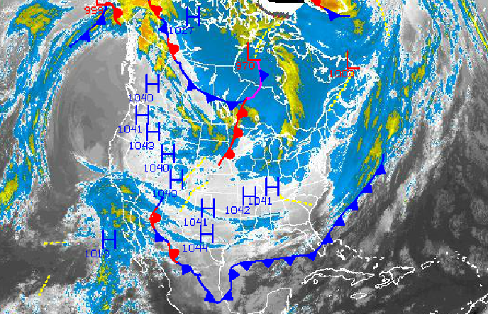
More cold air is on the way for the Philadelphia and New York City metropolitan areas with the threat for snow showers and snow squalls. Snowfall accumulations will be expected tomorrow and will range from one to four inches in some locations. The potential for more snowfall is possible but the primary impacts will be the Arctic cold air.
High pressure will be in place through this evening with clear skies to scattered clouds. Winds will back from the northwest to southwest at 5 to 15 mph. Temperatures will rise into the mid to upper 10's for highs this afternoon.
Tonight through tomorrow, clouds will increase with winds from the southwest at 10 to 20 mph ahead of an Arctic cold front. Temperatures will fall into the lower to mid 10's for lows.
Find out what's happening in Freeholdfor free with the latest updates from Patch.
The Arctic cold front will move through the region tomorrow between 10 AM and 6 PM with scattered snow showers and snow squalls. Snowfall accumulations will range from one to four inches in accumulation throughout the region. Winds will veer to the northwest at 10 to 20 mph as the cold front moves through. Temperatures will peak into the lower to mid 30's for highs before rapidly falling through the 20's and 10's. The snow squalls will feature a rapid fall in visibility and snowfall will accumulate quickly.
High pressure will be in control on Sunday with scattered clouds. Temperatures will range from the lower to mid 10's for lows and upper 10's to lower 20's for highs.
Find out what's happening in Freeholdfor free with the latest updates from Patch.
Another Alberta Clipper will move through the region on Monday with more scattered snow showers. Temperatures will range from the upper 10's to lower 20's for lows and lower to mid 30's for highs.
Arctic high pressure will be in place Tuesday through Thursday with scattered cloud cover expected. An area of low pressure will be off the coast on Wednesday morning and may produce a few scattered snow showers over the region. At this time, the storm track will be well to the east of the region keeping the more significant snowfall over the coastal waters. However, the track of this low pressure system needs to be monitored. Temperatures will remain well below normal through the period. Low temperatures will range from the single digits to lower 10's through the period. High temperatures will range from the upper 10's to lower 20's for highs.


