

Another weekend, another winter storm. This winter pattern sure has started off with a bang and we aren't even officially in winter yet, that's on December 21! A major winter storm is set to target the Philadelphia and New York City metropolitan areas starting tomorrow morning and continuing through Sunday morning with snow, sleet, and rain. High pressure takes hold thereafter with tranquil weather conditions for much of next week, which is exactly what the region needs for everyone to get their shopping done. Plus, I have baking to do!
An arctic cold front will move through the region today with scattered clouds and possibly a flurry or two. Otherwise, tranquil conditions can be expected with winds veering to the north at 5 to 15 mph. Temperatures will rise into the lower to mid 30's for highs throughout the Philadelphia and New York City metropolitan areas.
Tonight, arctic high pressure will build into the region with scattered clouds in the evening increasing to overcast skies by tomorrow morning. Winds will be from the north-northeast at 5 to 15 mph. Temperatures will fall into the mid to upper 10's over the interior and lower to mid 20's along the coast.
Find out what's happening in Freeholdfor free with the latest updates from Patch.
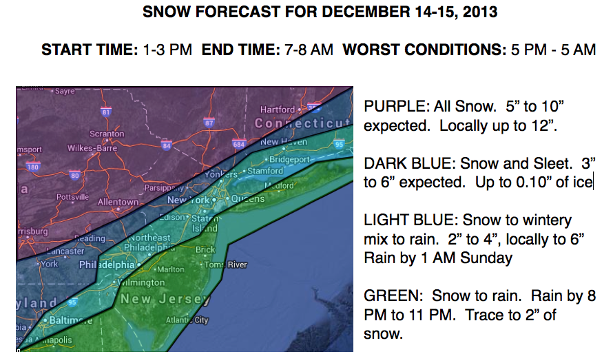
Tomorrow, an area of low pressure will approach from the Tennessee River Valley and move towards the southern New Jersey coast by tomorrow evening. Periods of snow can be expected over the interior with accumulations over six inches. The snow will change to rain along the coast with only a trace to two inches over southern New Jersey and two to four inches over the Philadelphia and New York City metropolitan areas. Details on snow accumulations can be seen below. Winds will veer to the northeast at 10 to 20 mph. Temperatures will rise into the upper 20's to lower 30's over the interior, lower to mid 30's over the Philadelphia and New York City metropolitan areas, and upper 30's to mid 40's along the New Jersey coast.
The low pressure system will exit on Sunday morning with snow tapering off over the interior and rain changing back over to snow along the coast. Winds will back to the northwest at 15 to 30 mph. Temperatures will fall into the upper 20's to lower 30's through the day.
Find out what's happening in Freeholdfor free with the latest updates from Patch.
High pressure will be in control Sunday night through Thursday with tranquil weather conditions expected. Scattered clouds can be expected with temperatures slowly moderating back to normal through next week. Temperatures on Monday will range from the upper 10's to lower 20's for lows and upper 20's to lower 30's for highs. Temperatures on Tuesday through Thursday will range from the mid 20's to lower 30's for lows and upper 30's to lower 40's for highs.


