Winter is returning with a vengeance today with falling temperatures through today, a threat for snow tomorrow morning, and a significant winter storm for Sunday night into Monday morning for much of the interior of the northern Mid Atlantic. Arctic cold air will return for early next week, keeping icy roads a threat.
Today, the Arctic cold front will continue to drop south through the Philadelphia and New York City metropolitan areas with periods of rain expected. Temperatures have already peaked this morning in the mid 50's to lower 60's for highs. Temperatures will fall through the day into the 40's and 30's by this evening. Winds will veer to the northwest at 5 to 15 mph, increasing to 10 to 20 mph by the evening.
Tonight, as the Arctic cold front exits off the coast, the rain will change over to snow with some minor accumulations over the interior and a dusting possible along the coast. Details on the snow threat for tomorrow morning can be found here. Winds will be from the north at 5 to 15 mph. Temperatures will fall into the mid to upper 20's over the interior and lower to mid 30's along the coast.
Find out what's happening in Freeholdfor free with the latest updates from Patch.
Tomorrow afternoon through Sunday afternoon, Arctic high pressure will be in control with clearing skies expected. Winds will be from the north at 5 to 10 mph. Temperatures will rise into the mid 30's over the interior and upper 30's to lower 40's along the coast. Temperatures on Sunday morning will range from the mid 10's to lower 20's over the interior and mid to upper 20's along the coast for lows. High temperatures on Sunday will range from the upper 20's to lower 30's over the interior and lower to mid 30's along the coast.
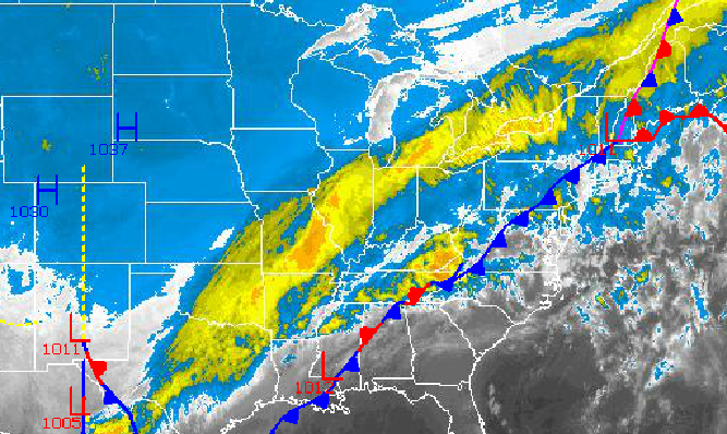
An area of low pressure currently over the Southwestern United States will dive towards the Gulf of Mexico and then lift northward towards the Ohio River Valley on Sunday. A warm front ahead of this low pressure system will slowly lift northward as well. Clouds will increase through the day on Sunday with periods of light snow developing by evening. As warm air invades from the Atlantic Ocean and from the Gulf Coast, the snow will gradually change over to rain along the coast and a mix of sleet and freezing rain over the interior, especially over northwestern New Jersey and interior eastern Pennsylvania. The precipitation will end from southwest to northeast on Monday morning. Details on what to expect can be found here. Temperatures will slow rise through the period with high temperatures on Monday in the upper 30's to lower 40's over the interior and mid to upper 40's along the coast.
Find out what's happening in Freeholdfor free with the latest updates from Patch.
The cold front will follow on Monday night with rain and snow showers. High pressure will take hold by Tuesday morning and remain in control through Wednesday with clear skies to scattered cloud cover. Temperatures will be well below normal. Temperatures for Tuesday and Wednesday will range from the mid 10's to lower 20's for lows and mid 20's to lower 30's for highs.


