Weather
Severe Thunderstorm Watch In 10 NJ Counties (UPDATED)
UPDATE: The possibility of a bad storm increased: Videos showed lightning and storm damage on Thursday as hundreds were still without power.


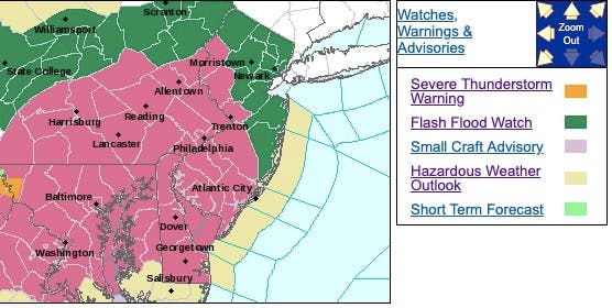
The National Weather Service issued a severe thunderstorm watch for 10 New Jersey counties Thursday now that more severe weather is expected.
The worst of the weather is supposed to start sometime between, or after, 3 and 5 p.m. At 4:25 p.m., a strong thunderstorm was located over Tatamy, or near Easton, Pa., moving east at 20 mph. Wind gusts up to 40 mph and pea-size hail were possible with this storm.
The counties that are under the watch, which is in effect until 10 p.m., are Warren, Hunterdon, Mercer, Burlington, Atlantic, Cape May, Cumberland, Salem, Camden and Gloucester.
Find out what's happening in Gloucester Townshipfor free with the latest updates from Patch.
Hundreds were still without power during the mid-day hours as residents were still recovering from lightning and storm damage (see videos below).
The National Weather Service also issued a hazardous weather outlook and a coastal flood watch for most of the state, saying the risk of severe weather Thursday afternoon and into this evening as thunderstorms could produce damaging winds and large hail.
Find out what's happening in Gloucester Townshipfor free with the latest updates from Patch.
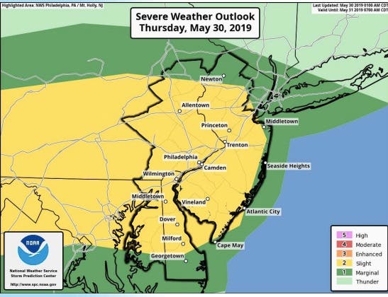
Showers and thunderstorms will move into eastern Pennsylvania and much of New Jersey this afternoon and through this evening, according to the NWS. Thunderstorms will be capable of heavy rainfall, and training of thunderstorms is also possible.
Total rain amounts will range from 1 to 2 inches with locally higher amounts possible. Flash flooding is possible in places where the heaviest thunderstorms persist.
Here is what the NWS is saying:
Here are the towns that still have power outages after two days of storms:
- OCEAN TOWNSHIP 87
- WEST CALDWELL TWP 57
- MAGNOLIA BORO 56
- HARDWICK TOWNSHIP 53
- SOUTH ORANGE VILLAGE TWP 47
- HOPATCONG BOROUGH 42
- CHESTER TOWNSHIP 38
- MILFORD BOROUGH 33
- ALEXANDRIA TOWNSHIP 21
- LAKEWOOD TOWNSHIP 17
- Pennsville Twp 15
- STILLWATER TOWNSHIP 14
- PISCATAWAY TWP 12
- VOORHEES TWP 8
- MAPLEWOOD TWP 5
Videos and photos show that a number of places endured damage from lightning strikes and flooding. A house in Lakewood suffered damage on the roof, according to The Lakewood Scoop, while areas of Morris County were still dealing with issues from Tuesday's storm and a tornado that was identified in the area:
#njmornings Although much has been taken care of, there’s still signs of Tuesday’s tornado in #Roxbury. Live updates this morning @News12NJ pic.twitter.com/WyVJqwx5lN
— Tony Caputo (@TonyCaputo) May 30, 2019
pic.twitter.com/d9c0aFOurq
— The Lakewood Scoop (@LakewoodScoop) May 29, 2019
At the scene where a home was struck by lightning in Lakewood. https://t.co/bIk6wuQBOV pic.twitter.com/fE7rZHGwNi
— The Lakewood Scoop (@LakewoodScoop) May 29, 2019
Lightning on the beach @6abcadamjoseph @CecilyTynan @ABC #Avalon #NJ pic.twitter.com/L9ikqyAOkD
— Madison (@MadisonSays) May 29, 2019
Storms coming into central NJ. This lightning strike was just now pic.twitter.com/jkkXRWQpxY
— Mark Spencer (@markasp138) May 29, 2019
Thursday will mark the third straight day of severe weather across the region, following storms bringing widespread hail, wind damage, flooding and even a few tornadoes during Tuesday and Wednesday, according to AccuWeather. The same areas that dealt with severe weather on Tuesday and Wednesday are likely to face a similar risk again during Thursday afternoon and evening.
"The strongest storms can bring hail and damaging wind gusts from parts of central Ohio to central New Jersey," AccuWeather Meteorologist Maura Kelly said in a release.
.jpeg)
- Thursday: A chance of showers and thunderstorms, mainly after 4pm. Mostly cloudy, with a high near 82. Light southwest wind becoming south 5 to 10 mph in the afternoon. Chance of precipitation is 30%. New rainfall amounts between a quarter and half of an inch possible.
- Thursday night: Showers and thunderstorms likely, mainly before 10pm. Some of the storms could produce small hail, gusty winds, and heavy rain. Patchy fog after midnight. Otherwise, cloudy, then gradually becoming partly cloudy, with a low around 62. Southwest wind 7 to 9 mph becoming west after midnight. Chance of precipitation is 70%. New rainfall amounts between a quarter and half of an inch possible.
- Friday: Mostly sunny, with a high near 82. West wind 7 to 9 mph.
- Friday night: Partly cloudy, with a low around 60. Southwest wind around 5 mph becoming calm in the evening.
Get more local news delivered straight to your inbox. Sign up for free Patch newsletters and alerts.