Weather
NJ Weather: Timeline For Severe Storms, Possible Damaging Winds
Thunder, lightning, hail and other potential threats are coming from this storm system. Flooding was already causing problems. Here's where.


A summer-like storm system is heading for New Jersey, one that is supposed to pack a punch with potentially damaging winds, thunder, lightning, hail and heavy downpours. Flooding was already impacting some areas of New Jersey on Tuesday.
The worst of it is supposed to happen after 10 a.m. on Wednesday, when severe thunderstorms are expected to impact New Jersey – primarily in the northern and central areas of the state. Rainfall will be steady beginning on Tuesday morning, and as many as 2 inches could fall through Wednesday evening.
Rescues were already happening in North Jersey, particularly in Bergen County. Read more: Rescues On Bergen County Streets As Floods Besiege Area
Find out what's happening in Hillsboroughfor free with the latest updates from Patch.
Floodwaters were also causing problems in Hudson County. Read more: Hudson County Flooding: Streets Closed Amid Heavy Rain (WATCH)
The Wednesday evening commute could be especially rough for New Jersey commuters, forecasters say.
Find out what's happening in Hillsboroughfor free with the latest updates from Patch.
-1537879830-276.jpg)
The National Weather Service has issued a hazardous weather outlook for the entire state, saying there is a slight risk of severe thunderstorms Wednesday afternoon into Wednesday evening. The primary hazard with these storms is expected to be damaging winds.
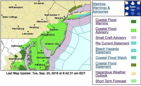
A coastal flood advisory also was issued for the Jersey Shore, since coastal flooding is expected with the high tide between 8 and 9 a.m. on Tuesday.
Up to one-half foot of saltwater inundation is possible in low-lying areas near shorelines and tidal waterways. Minor roadway flooding is possible for coastal locations in Monmouth County. In Middlesex County, minor road flooding is possible in Woodbridge Township, Perth Amboy, Old Bridge Township, and South Amboy.
Minor roadway flooding is possible on Long Beach Island, Seaside Heights, Point Pleasant Beach and other locations near Barnegat Bay. Waves could be anywhere from 5 to 8 feet along the oceanfront.
The severe storms heading for New Jersey will first develop early Tuesday afternoon in southern Wisconsin, eastern Iowa and northern Illinois and then gradually merge into a line by the late-afternoon hours, according to AccuWeather.
By Wednesday, severe thunderstorms will be possible from Montreal, Canada, down through Syracuse and Pittsburgh, with severe weather approaching the I-95 corridor by Wednesday evening, AccuWeather says.
Similar to Tuesday, the main threats from Wednesday’s storms will be flooding downpours and damaging winds.
Motorists traveling home from work on Wednesday from Boston, New York, New Jersey to Washington, D.C., may face dangerous crosswinds and rapid reductions in roadway visibility over only a few hundred feet, according to AccuWeather.
Large portions of Interstates 80 and 95, as well as secondary roads, may be impacted by street and highway flooding through midweek, according to AccuWeather.

Here is the forecast:
- Tuesday: Showers. High near 68. East wind 8 to 11 mph becoming south in the afternoon. Chance of precipitation is 100%. New precipitation amounts between three quarters and one inch possible.
- Tuesday night: Showers likely, mainly before 7pm. Cloudy, with a low around 66. South wind around 7 mph. Chance of precipitation is 60%. New precipitation amounts between a tenth and quarter of an inch possible.
- Wednesday: A chance of showers, then showers and thunderstorms likely after 11am. Some of the storms could produce small hail, gusty winds, and heavy rain. Cloudy, with a high near 76. South wind 6 to 9 mph. Chance of precipitation is 60%. New rainfall amounts between a tenth and quarter of an inch, except higher amounts possible in thunderstorms.
- Wednesday night: Showers and thunderstorms likely before 2am, then a slight chance of showers. Some of the storms could produce small hail, gusty winds, and heavy rain. Cloudy, then gradually becoming partly cloudy, with a low around 53. North wind 6 to 9 mph. Chance of precipitation is 60%. New rainfall amounts of less than a tenth of an inch, except higher amounts possible in thunderstorms.
Photo credit: Shutterstock
Get more local news delivered straight to your inbox. Sign up for free Patch newsletters and alerts.