Weather
NJ Nor'easter: Latest Snow Estimates, Winter Weather Advisory
Three inches of snow fell in parts of NJ Tuesday for what's expected to be the third nor'easter to hit the state in 10 days.

A winter weather advisory remains in place for the third nor'easter to strike New Jersey in 10 days. The state already had a few issues on the roads during the Tuesday commute, 3 inches of snow fell in parts of the state and dozens of schools closed. See below for the latest snow estimates.
Dozens of schools have delayed openings. Read more: New Jersey School Closings/Delays List For 3/13/18
The storm produced 3 inches of snow in some parts of North Jersey and an inch or two at the Jersey Shore. We will provide totals through the day – check here for updates Tuesday: New Jersey Snow Totals, Town-By-Town - 3/13/18
Find out what's happening in Hobokenfor free with the latest updates from Patch.
Here are the road conditions:
- Garden State Parkway: Speed restriction on the Garden State Parkway in both directions from Driscoll Bridge in Sayreville to Exit 127 - US 9/I-287/NJ 440 in Woodbridge Twp; 35 miles per hour due to roadway conditions.
- Outerbridge Crossing: Speed restriction on the Outerbridge Crossing in both directions between New Jersey side in Perth Amboy and New York side in Staten Island; 30 miles per hour due to weather.
- Garden State Parkway: Road treatment in progress and a speed restriction on the Garden State Parkway in both directions from north of Exit 30 - NJ 52/Laurel Drive in Somers Point to south of Montvale Service Area in Montvale; 45 miles per hour, for full salting operation.
- New Jersey Turnpike: Speed restriction on the New Jersey Turnpike in both directions from Delaware Memorial Bridge in Pennsville Twp to George Washington Bridge in Fort Lee 45 miles per hour salting operations.
- New Jersey Turnpike - Pennsylvania Ext.: Speed restriction on the New Jersey Turnpike - Pennsylvania Ext. in both directions Delaware River Bridge in Burlington Twp; 45 miles per hour salting operations.
- New Jersey Turnpike - Hudson County Extension: Speed restriction on the New Jersey Turnpike - Hudson County Extension in both directions from Interchange 14 - I-78 in Newark to Jersey Ave/Holland Tunnel in Jersey City; 45 miles per hour salting operations.
- NJ 17: Accident on NJ 17 southbound north of US 46 in Hasbrouck Heights. Right lane closed 5-10 minute delay, use caution.
- I-80: Accident and a fuel spill on I-80 westbound West of Exit 12 - CR 521/Hope-Blairstown Rd in Hope Twp. Right and center lanes closed; 5-10 minute delay, use caution.
- Goethals Bridge: Speed restriction on the Goethals Bridge in both directions from New Jersey side in Elizabeth to New York side in Staten Island of 30 miles per hour due to long term construction.
- Delays Delays I-280 As of 6:40am, there are Delays on I-280 eastbound from Exit 12 - Garden State Parkway in East Orange to Exit 15 - NJ 21 in Newark delays due to volume.
- Delays Delays I-80 As of 6:39am, there are Delays on I-80 eastbound from Exit 28 - CR 631/US 46 in Roxbury Twp to Exit 35 - Mount Hope Av in Rockaway Twp delays due to volume.
- New Jersey Turnpike - Eastern Spur: Delays on the New Jersey Turnpike - Eastern Spur outside exit Interchange 15E - US 1&9 in Newark due to delays on US 1&9.
- I-295 : Delays on I-295 southbound from Exit 32 - CR 561/Haddonfield Berlin Rd in Cherry Hill Twp to Exit 26S - NJ 42/I-76/I-676 in Bellmawr delays due to volume.
- NJ 73: NJ 73 southbound from NJ 38 in Maple Shade Twp to CR 544/Evesham Rd/Marlton Pkwy in Evesham Twp delays due to volume.
- NJ 3: Delays on NJ 3 eastbound from NJ 21 in Clifton to NJ 120/Paterson Plank Road/New Jersey Turnpike - Western Spur in East Rutherford delays due to volume.
- NJ 73: Delays on NJ 73 northbound from CR 544/Evesham Rd/Marlton Pkwy in Evesham Twp to NJ 38 in Maple Shade Twp delays due to volume.
- NJ 129: Delays on NJ 129 northbound from NJ 29 in Hamilton Twp to US 1 in Trenton delays due to volume.
- NJ 495: Delays on NJ 495 eastbound from New Jersey Turnpike in Secaucus to Lincoln Tunnel in Weehawken Twp delays due to volume.
- I-295: Delays on I-295 northbound from Exit 47 - CR 541/Burlington-Mount Holly Rd in Burlington Twp to Exit 60 - I-195/NJ 129 in Hamilton Twp delays due to volume.
- I-295: Delays on I-295 northbound from Exit 26N - I-76/I-676 in Bellmawr to Exit 34 - NJ 70 in Cherry Hill Twp delays due to volume.
- I-195: Delays on I-195 westbound from Exit 7 - CR 526 in Robbinsville to I-295 in Hamilton Twp delays due to volume.
- I-76: Delays on I-76 westbound from Exit 1A - NJ 42/I-295 in Bellmawr to Walt Whitman Bridge in Gloucester City delays due to volume.
- NJ 55: Delays on NJ 55 northbound from Exit 58 - Deptford Center Rd to NJ 42 in Deptford Twp delays due to volume.
- NJ 42: Delays on NJ 42 northbound from Exit 10A - NJ 168/Black Horse Pike in Gloucester Twp to I-295 in Bellmawr delays due to volume.
- New Jersey Turnpike - Hudson County Extension: Delays on the New Jersey Turnpike - Hudson County Extension eastbound from Interchange 14 - I-78 to East of Newark Bay Bridge in Newark 2 mile delay, due to volume.
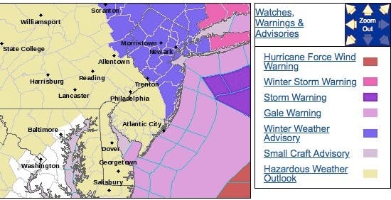
A winter weather advisory has been issued for North Jersey, Central Jersey and Jersey Shore The rest of the state is under a hazardous weather outlook; less than 2 inches is expected in South Jersey and the southern part of the Jersey Shore. Here are the alerted areas:
Find out what's happening in Hobokenfor free with the latest updates from Patch.
Either way, the Tuesday morning commute will be adversely affected, as snow will likely keep falling through sunrise. Plan on slippery road conditions, especially on untreated surfaces and especially during the morning commute Tuesday. Also, be prepared for reduced visibilities at times.
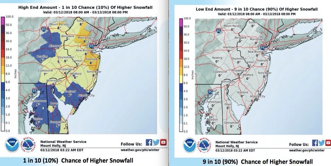
Here are the latest snow estimates:
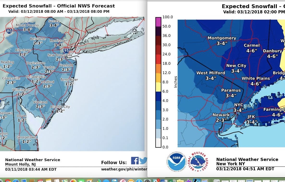
Joe Miketta, a National Weather Service meteorologist, said the only question is how strong the storm will be. Since it's tracking westward, he expects estimated snow totals could rise throughout the day.
The National Weather Service offered two possible scenarios. Parts of the state could get no more than 1 inch if the storm pushes back out to sea. If the trend continues, however, parts of the state could get as many as 8 inches.
Scattered snow squalls are also expected to move southeast through New Jersey Wednesday, especially during the afternoon, that could deposit a quick 1/2 inch to 1 inch of snow, making stretches of pavement very slippery as temperatures briefly fall to near-freezing in the squalls, according to the NWS
Additionally, visibility could be briefly but sharply reduced to a quarter-mile in some spots, so be on alert for suddenly changing travel conditions Wednesday.
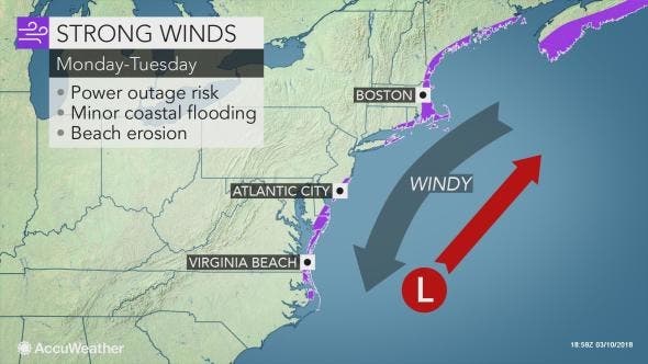
AccuWeather says the storm is expected to rapidly strengthen on Tuesday, potentially becoming a "bomb cyclone" — a storm that resembles a hurricane but is much less powerful.
While the strongest and most damaging winds are predicted to remain offshore, the storm could still track close enough to threaten the coast with gusty winds and coastal flooding while spreading disruptive snow from the southern mid-Atlantic to New England, according to AccuWeather.
As the snow spreads across the southern mid-Atlantic Monday, winds will increase along the coast from North Carolina to New Jersey, according to AccuWeather. Minor coastal flooding may result at high tide.
Here is the forecast:
- Tuesday: Snow likely before noon, then a chance of rain showers. Mostly cloudy, with a high near 46. Northwest wind 13 to 15 mph. Chance of precipitation is 60%. New snow accumulation of less than one inch possible.
- Tuesday night: Partly cloudy, with a low around 28. West wind around 10 mph.
- Wednesday: Scattered snow showers before 1pm, then scattered rain showers. Partly sunny, with a high near 41. West wind 11 to 16 mph. Chance of precipitation is 30%. New snow accumulation of less than a half inch possible.
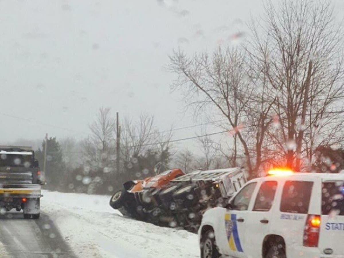
State Police police photo
Get more local news delivered straight to your inbox. Sign up for free Patch newsletters and alerts.