Weather
Severe Thunderstorms, Flash Flood Watch Issued In Parts Of NJ
A flash flood watch has been issued in areas of the Garden State, where up to four inches of rain are predicted Monday amid more storms.

4:15 p.m. Update: A severe thunderstorm watch is in effect until 11 p.m. for the following northern and central New Jersey counties: Bergen, Essex, Hunterdon, Monmouth, Passaic, Sussex, Burlington, Gloucester, Mercer, Morris, Salem, Union, Camden, Hudson, Middlesex, Ocean, Somerset and Warren. A flash flood warning is in effect for Burlington County.
NEW JERSEY — Forecasters predict severe thunderstorms, excessive rainfall and dangerous cloud-to-ground lightning on Monday afternoon, which could bring up to four inches of rain and induce flash flooding in parts of the Garden State.
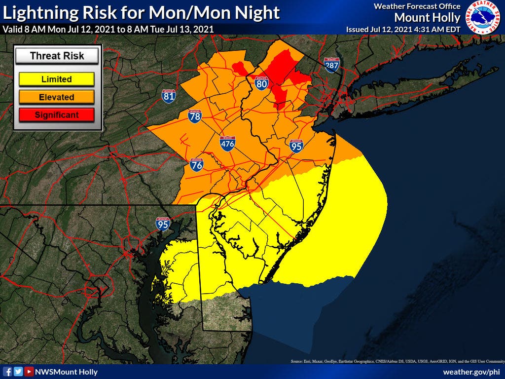
The National Weather Service estimates that most of the state will see one to three inches of rain, while the northeastern portion of New Jersey may see as much as four inches of precipitation. The heaviest rainfall will occur overnight north of Interstate 195, the agency said.
Find out what's happening in Holmdel-Hazletfor free with the latest updates from Patch.
From 2 p.m. on Monday until 5 a.m. on Tuesday, a flash flood watch will be in effect for 10 New Jersey counties. A flash flood watch is issued when there is a potential for rapid-onset flooding based on current forecasts.
"Heavy rain in a short period of time may cause streams and creeks to rise quickly out of their banks," the National Weather Service said. "There is also the potential for flash flooding across more urbanized areas and those areas with poor drainage."
Find out what's happening in Holmdel-Hazletfor free with the latest updates from Patch.


Here are the affected counties:
- Middlesex
- Morris
- Camden
- Gloucester
- Hunterdon
- Mercer
- Burlington
- Monmouth
- Somerset
- Sussex
- Warren
- Bergen
- Essex
- Passaic
- Union
- Hudson
A heat advisory has also been issued for three Garden State counties from 11 a.m. on Monday until 8 p.m. on Tuesday. A heat advisory is issued when temperatures are expected to reach 105 to 109 degrees or 100 to 104 degrees within 24 hours.
On Monday and Tuesday, temperatures will hover around the 100-degree mark with temperatures as high as 105, according to the National Weather Service. Tuesday and Wednesday may also see severe thunderstorms, with temperatures expected to remain around the 90s throughout the week, per AccuWeather. There is a high risk of fog in the state on Tuesday.
"Hot temperatures and high humidity may cause heat illnesses to occur," the agency said. "Drink plenty of fluids, stay in an air-conditioned room, stay out of the sun, and check up on relatives and neighbors. Young children and pets should never be left unattended in vehicles under any circumstances."
Here are the affected counties:
- Gloucester
- Burlington
- Camden
"Take extra precautions if you work or spend time outside," the service continued in a statement. "When possible reschedule strenuous activities to early morning or evening. Know the signs and symptoms of heat exhaustion and heat stroke. Wear lightweight and loose fitting clothing when possible. To reduce risk during outdoor work, the Occupational Safety and Health Administration recommends scheduling frequent rest breaks in shaded or air conditioned environments. Anyone overcome by heat should be moved to a cool and shaded location. Heat stroke is an emergency! Call 9-1-1."
In addition, several rounds of showers & thunderstorms this afternoon & evening will result in heavy rain & possible flash flooding. A Flash Flood Watch is in effect for northern NJ from this afternoon through late tonight. #NJwx pic.twitter.com/G3PGnPNUF4
— NWS Mount Holly (@NWS_MountHolly) July 12, 2021
Here’s the latest forecast:
Monday: A chance of showers, then showers and thunderstorms likely after 2 p.m. Some of the storms could produce gusty winds and heavy rain. Mostly cloudy. Light and variable wind becoming southwest around 5 mph in the afternoon. Chance of precipitation is 70 percent.
Monday Night: Showers and thunderstorms likely before 1 a.m., then showers likely and possibly a thunderstorm between 1 and 4 a.m., then a chance of showers and thunderstorms after 4 a.m. Some of the storms could produce gusty winds and heavy rain. Patchy fog after 4 a.m. Otherwise, cloudy, with a low around 70. East wind around 6 mph. Chance of precipitation is 70 percent.
Tuesday: A chance of showers, with thunderstorms also possible after 1 p.m. Patchy fog before 7 a.m. Otherwise, mostly cloudy, with a high near 82. East wind around 6 mph. Chance of precipitation is 30 percent.
Tuesday Night: A chance of showers and thunderstorms. Patchy fog after 3 a.m. Otherwise, mostly cloudy, with a low around 72. Southeast wind around 6 mph to become calm after midnight. Chance of precipitation is 40 percent.
Get more local news delivered straight to your inbox. Sign up for free Patch newsletters and alerts.