Weather
NJ Weather: Strong Storms, Heat Kick Off July 4
As you're getting ready to celebrate July 4 with friends and family, heavy storms and a 115-degree heat index may impact your life.


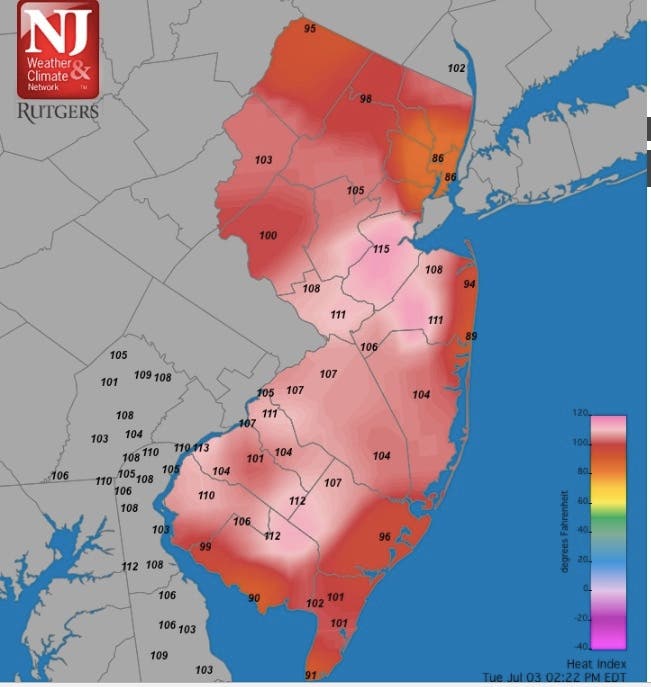
As you're getting ready to celebrate the Fourth of July with friends and family, be aware that some stormy weather and extreme heat could pass through to impact your commute and kick off the holiday. The heat index hit 115 degrees in some parts of New Jersey on Tuesday.
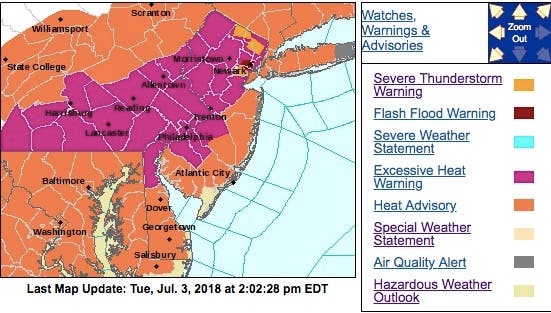
The National Weather Service issued severe thunderstorm warning for parts of New Jersey on Tuesday, saying there was a chance of storms on Tuesday evening. The storms could bring heavy rainfall and even flash flooding, the NWS said.
A lightning bolt even set one house in Ridgewood on fire. Read more: Lightning Strike Sets Ridgewood Home On Fire
Find out what's happening in Manasquan-Belmarfor free with the latest updates from Patch.
The storms and heat could impact your fireworks plans. Read more: New Jersey July 4th Fireworks, Parades and More: 2018 Guide
The severe thunderstorm warning was for Hudson, Union, Bergen, Passaic and Essex counties. Up to 60-mph wind gusts and damage to trees and power lines are possible. A flash-flooding warning was issued for Union.
Find out what's happening in Manasquan-Belmarfor free with the latest updates from Patch.
The storms were impacting local flights.
Due to WX:Thunderstorms, arrival traffic is experiencing airborne delay between 16-30-increasing. Due to WX:Thunderstorms, arrival traffic is experiencing airborne delay between 31-45-increasing. #EWR
— EWR Flight Delays (@FlyFAA_EWR) July 3, 2018
Here are the alerted areas:
There was also a chance of showers and thunderstorms on Wednesday. Some of those storms could produce heavy rainfall, and again, the chance of flash flooding. The chance of storms Wednesday is 30 percent.
The Jersey Shore counties of Ocean, Atlantic and Cape May counties are supposed to be largely unaffected by the storms.
Additionally, expect the intense heat to linger through the holiday. "Dangerously hot conditions are possible through at least Independence Day," the NWS warned.
Here is a map showing the heat indexes in New Jersey at 2:30 p.m.:
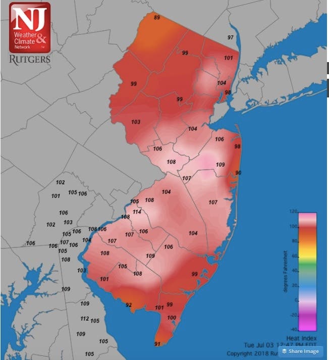
Here is a map showing the heat indexes in New Jersey at 1 p.m.:
The heat also led to some horrible incidents. Four children were left sitting in a hot car while two mothers attempted to shoplift in East Hanover this week, police said. Read more: 4 Kids Left In Hot Car While Moms Shoplifted: East Hanover Police
Also, a Brick Township man is facing animal cruelty charges in the wake of the death of his dog after it was left caged on a fire escape for several hours on Sunday, police said. Read more: Dog Caged Outside In Heat Dies; Brick Man Charged: Police
Another round of showers and thunderstorms with heavy rainfall is possible Friday.
The good news: The intense heat will break by late week. A high of 87 is predicted Friday and a high of 81 on Saturday.
Here is the forecast: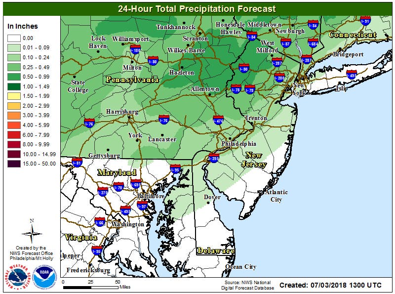
Today: A chance of showers and thunderstorms, mainly after 2pm. Some of the storms could produce heavy rain and frequent lightning. Mostly cloudy, with a high near 95. Heat index values as high as 106 to 114. Light southeast wind. Chance of precipitation is 40%. New rainfall amounts between a tenth and quarter of an inch, except higher amounts possible in thunderstorms.
Tonight: A chance of showers and thunderstorms, mainly before 8pm. Some of the storms could produce heavy rain and frequent lightning. Patchy fog after 3am. Otherwise, mostly cloudy, with a low around 73. Calm wind. Chance of precipitation is 30%. New rainfall amounts of less than a tenth of an inch, except higher amounts possible in thunderstorms.
Wednesday: A chance of showers and thunderstorms. Patchy fog before 8am. Otherwise, mostly cloudy, with a high near 89. Calm wind becoming east around 6 mph in the afternoon. Chance of precipitation is 30%. New rainfall amounts between a tenth and quarter of an inch, except higher amounts possible in thunderstorms.
Wednesday Night: A slight chance of showers and thunderstorms before 2am. Patchy fog after 2am. Otherwise, mostly cloudy, with a low around 72. South wind 3 to 5 mph. Chance of precipitation is 20%.
Thursday: A slight chance of showers and thunderstorms after 8am. Patchy fog before 8am. Otherwise, partly sunny, with a high near 89. Calm wind becoming south 5 to 7 mph in the afternoon. Chance of precipitation is 20%.
Thursday Night: A slight chance of showers and thunderstorms. Patchy fog after 2am. Otherwise, mostly cloudy, with a low around 72. Chance of precipitation is 20%.
Friday: Showers and thunderstorms likely. Some of the storms could produce heavy rain. Patchy fog before 8am. Otherwise, mostly cloudy, with a high near 87. Chance of precipitation is 70%.
Friday Night: A chance of showers and thunderstorms. Some of the storms could produce heavy rain. Mostly cloudy, with a low around 66. Chance of precipitation is 50%.
With reporting by Kara Seymour
Image via Shutterstock
Get more local news delivered straight to your inbox. Sign up for free Patch newsletters and alerts.