Weather
Timeline Of Possible Thunderstorms Saturday
Evening thunderstorms are possible Saturday. Full forecast here.

Will thunderstorms hit New Jersey today?
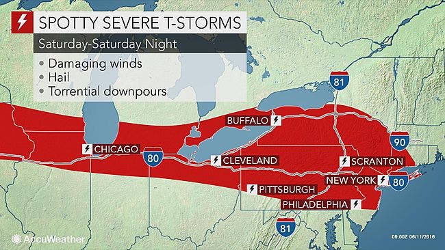
The National Weather Service has issued a Hazardous Weather Outlook across New Jersey, saying "severe" thunderstorms are possible Saturday afternoon and evening, with hail, strong winds and "torrential downpours."
Some of these storms could produce heavy rain, which could lead to flooding in areas with poor drainage, according to the weather service.
Find out what's happening in Mendham-Chesterfor free with the latest updates from Patch.
While the situation does not look as volatile as it appeared earlier this week, the storms have the potential to pack a punch in some communities, according to an AccuWeather release.
"In addition to frequent lightning strikes, the main threats from the storms will be for damaging winds and hail into Saturday night," AccuWeather Storm Warning Meteorologist Alex Avalos said.
Find out what's happening in Mendham-Chesterfor free with the latest updates from Patch.
Here's the latest storm timeline, according to the National Weather Service:
SATURDAY
- 2 to 5 p.m. - A slight chance of showers. Partly sunny, with a high near 85. Southwest wind 7 to 17 mph. Chance of precipitation is 2 percent.
- 5 p.m. to 11 p.m. - A stronger chance of rain, thunder, hail possible, with 34 mph wind gusts. Mostly cloudy, with a low around 70. Southwest wind 9 to 15 mph. Chance of precipitation is 40 percent. New precipitation amounts between a 10th and quarter of an inch, except higher amounts possible in thunderstorms.
- 11 p.m. to 7 a.m. - Clearer, a slight chance of rain.
Get more local news delivered straight to your inbox. Sign up for free Patch newsletters and alerts.