Weather
Winter Storm May Dump 15+ Inches Of Snow On Millburn: What To Know
Things are about to get ugly in Millburn, forecasters say. Here are some useful reminders about parking, shoveling and power outages.


MILLBURN, NJ — Get ready to break out those snow shovels in Millburn, weather forecasters say.
A severe winter storm is expected to hit the region this weekend. Forecasts have shifted, but the latest predictions call for up to 18 inches of snow in some parts of New Jersey. Most of the snowfall is expected to happen from Saturday night to Monday.
Find out what's happening in Millburn-Short Hillsfor free with the latest updates from Patch.
The Millburn area is currently under a Hazardous Weather Outlook. In addition, a Winter Storm Watch is in effect from Sunday morning to Monday evening.
Millburn may see between seven and 11 inches of snow accumulation during the daytime hours on Sunday, with another two to four inches possible that evening. More snow is likely on Monday morning, according to the National Weather Service.
Find out what's happening in Millburn-Short Hillsfor free with the latest updates from Patch.
Here’s the local forecast for Millburn, according to the NWS:
- Saturday: Increasing clouds and cold, with a high near 18. Wind chill values between -5 and 5. Northwest wind 7 to 9 mph.
- Saturday Night: Snow likely after 1am. Cloudy, with a low around 12. Wind chill values between 5 and 10. North wind 3 to 5 mph. Chance of precipitation is 60%. New snow accumulation of less than one inch possible.
- Sunday: Snow. The snow could be heavy at times. High near 24. Northeast wind 7 to 14 mph, with gusts as high as 25 mph. Chance of precipitation is 100%. New snow accumulation of 7 to 11 inches possible.
- Sunday Night: Snow. Steady temperature around 22. Chance of precipitation is 100%. New snow accumulation of 2 to 4 inches possible.
- Monday: Snow likely, mainly before 1pm. Mostly cloudy, with a high near 26. Chance of precipitation is 60%.
- Monday Night: Partly cloudy, with a low around 7.
MILLBURN PREPARES FOR SNOW
The Millburn Office of Emergency Management (OEM) has been issuing storm updates and advising local residents to batten down the hatches for heavy snowfall.
Here are some things that Millburn residents should know ahead of the storm, officials said:
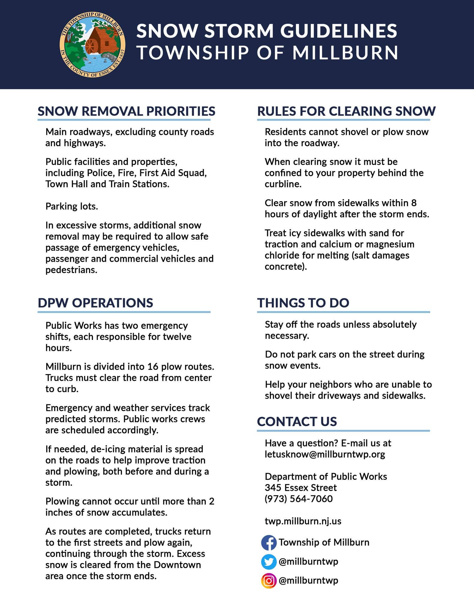
MOVE CARS AND SHOVEL - Residents are reminded to move their cars from streets and park them in driveways so our public works crews can clear streets if there is plowable snowfall. Public Works will begin plowing after an accumulation of two inches. Please shovel the walkways around your homes, but do not put shoveled snow back into the street after your street has been plowed.
ADVANCE SALTING - Millburn DPW has mobilized to respond to this weather event by ensuring that their equipment is prepared, and shifts are staffed. Salting operations will likely not occur in advance of this storm system beginning as a result of rain.
FIRST RESPONDERS READY - Millburn Police Department, Fire Department, and Emergency Medical Services are at a full complement of manpower on stand-by.
POWER OUTAGES - Localized power outages are possible. Residents are urged to stay away from any downed wires and treat all downed wires as “live” even if power appears to be out in the area.
DRIVING - Use caution while driving today and into the evening. Areas of icing on untreated surfaces are also possible in the evening into the overnight.
CO POISONING - Prevention Carbon Monoxide Poisoning - Do not run any fuel-powered generators in a garage or other enclosed space or near windows. This is a good time to test battery-powered smoke and carbon monoxide alarms.
Due to the impending winter storm, there will be no overnight street parking allowed in Millburn for the following dates:
- Saturday, January 24 - Sunday, January 25
- Sunday, January 25 - Monday, January 26
- Monday, January 26 - Tuesday, January 27
COLD WEATHER COMING IN ESSEX COUNTY
Essex County Executive Joseph DiVincenzo Jr. held an emergency snow preparedness meeting at the Turtle Back Zoo on Thursday, outlining the county’s plan to respond to the storm and coordinate with local municipalities.
“Although it is too early to determine how much snow we will get, the accumulation could be significant, and it could be the biggest storm we have experienced since 2021,” DiVincenzo said.
Meanwhile, Essex County has enacted a “Code Blue” alert ahead of the storm, which began Thursday evening and will continue until 9 a.m. on Saturday, Jan. 31.
Here’s what happens during a Code Blue, officials say:
“When a Code Blue is declared, a network of warming stations operated by the county and its municipalities and shelters operated by the community-based organizations will be opened. The warming stations identified include a variety of public libraries, senior centers, civic and community centers, school buildings, houses of worship, firehouses and first aid squad buildings. Warming stations are generally opened during the day and may not provide overnight accommodations. Shelters do provide overnight accommodations. In addition, shelters that regularly require occupants to leave during the day will suspend that practice so people can stay indoors.”
View a list of participating shelters below, visit www.NJ211.org or dial 2-1-1.
“The cold temperatures and inclement winter weather puts the health and safety of our homeless residents are risk,” Essex County Sheriff Amir Jones said.
“We appreciate our partner agencies opening their doors to provide a warm and safe place for those in need,” Jones added.

Send local news tips and correction requests to eric.kiefer@patch.com. Learn more about advertising on Patch here. Find out how to post announcements or events to your local Patch site.
Get more local news delivered straight to your inbox. Sign up for free Patch newsletters and alerts.