Weather
Hurricane Ida Remnants To Slam North Jersey: See Timeline
Heavy rain and flash flooding could impact New Jersey this week as remnants from Hurricane Ida move through the region. See what's expected.

NORTH JERSEY — Remnants of Hurricane Ida are expected to move through the northeast on Wednesday and Thursday, bringing heavy rain and potential for flash flooding throughout the Garden State.
Hurricane Ida hit Louisiana on Sunday as a Category 4 storm — Ida has since been downgraded to a tropical storm as it moves northeast. When the storm made landfall in Louisiana on Sunday morning, winds were reported to be as high as 150 mph, making it the fifth-strongest to ever hit the mainland United States.
Ida has weakened to a tropical storm with sustained winds of 60 mph as of Monday morning. But forecasters still expect New Jersey to feel its effects.
Find out what's happening in Morristownfor free with the latest updates from Patch.
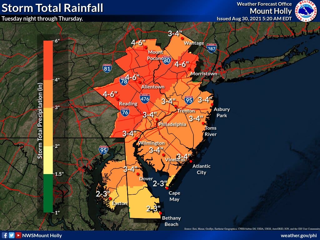
The National Weather Service has already issued a flash flood watch for 16 New Jersey counties from Wednesday morning through Thursday night, with widespread predictions of 3 to 5 inches of rain. But some of North Jersey may see even greater rainfall, potentially exceeding 6 inches in Hunterdon, Morris, Somerset and Warren Counties.
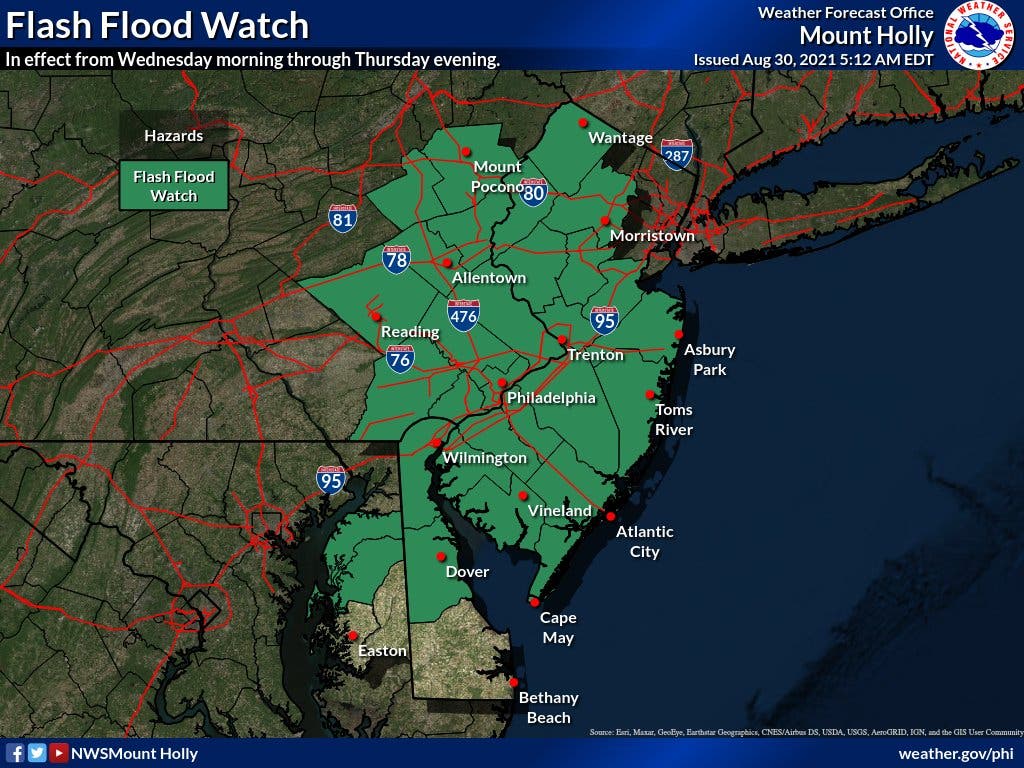
The flash flood watch includes the following counties:
Find out what's happening in Morristownfor free with the latest updates from Patch.
- Salem
- Cumberland
- Cape May
- Atlantic
- Gloucester
- Camden
- Burlington
- Ocean
- Monmouth
- Mercer
- Middlesex
- Somerset
- Hunterdon
- Warren
- Sussex
- Morris
The National Weather Service issued a hazardous weather outlook for Bergen, Essex, Hudson, Passaic and Union Counties. Forecasters expect moderate-to-heavy rainfall for the region Wednesday into Thursday. Flooding is possible, especially in urban and poor-drainage areas.
Hurricane Ida hit Louisiana on Sunday as a Category 4 storm, causing at least one death, according to officials. The entire city of New Orleans and 1 million customers throughout the state lost power.
Here's the forecast for the Newark International Airport as of Monday morning, according to the National Weather Service:
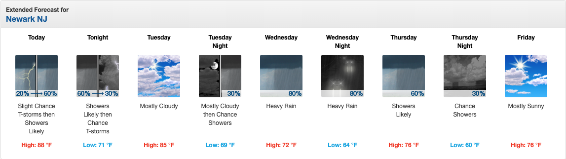
- Monday night: Showers likely and possibly a thunderstorm before 8pm, then a chance of showers and thunderstorms between 8pm and 2am. Mostly cloudy, with a low around 71. Southwest wind around 5 mph becoming light and variable in the evening. Chance of precipitation is 60%.
- Tuesday: Mostly cloudy, with a high near 85. West wind 5 to 7 mph.
- Tuesday night: A 30 percent chance of showers after 2am. Mostly cloudy, with a low around 69. West wind around 5 mph becoming calm in the evening.
- Wednesday: A chance of showers before 8am, then rain likely between 8am and 2pm, then rain and possibly a thunderstorm after 2pm. Some of the storms could produce heavy rainfall. Steady temperature around 72. Northeast wind 3 to 8 mph. Chance of precipitation is 80%. New rainfall amounts between a half and three quarters of an inch possible.
- Wednesday night: Rain, with thunderstorms also possible after 2am. Some of the storms could produce heavy rainfall. Low around 64. Chance of precipitation is 80%. New rainfall amounts between 1 and 2 inches possible.
- Thursday: Rain likely and possibly a thunderstorm before 2pm, then a chance of showers after 2pm. Mostly cloudy, with a high near 76. Chance of precipitation is 60%.
- Thursday night: A 30 percent chance of showers before 2am. Partly cloudy, with a low around 60.
- Friday: Mostly sunny, with a high near 76.
With reporting from Kimberlee Bongard/Patch
Get more local news delivered straight to your inbox. Sign up for free Patch newsletters and alerts.