Weather
Tornado Watch Issued In 15 Counties As Region Braces For Ida's Arrival [Latest Updates]
Forecasters warned of 6 inches of rain in some parts and an 'enhanced risk' of tornadoes in New Jersey.


Here are the latest developments as the storm arrives in New Jersey, updated as of 7 p.m. Wednesday:
- Severe thunderstorms have been detected from White House Station to Lawrenceville as of 7 p.m. Officials expect the thunderstorms to hit Hunterdon County, southeastern Morris County, Somerset County and Mercer County within the next hour. The weather could bring damage to roofs, siding, trees and power lines. Winds are moving northeast at 65 mph.
- A tornado watch has been issued until 1 a.m. Thursday for Bergen, Essex, Hudson, Passaic and Union Counties. The tornado watch for the remainder of New Jersey — except Sussex County — remains in effect until 10 p.m. Wednesday.
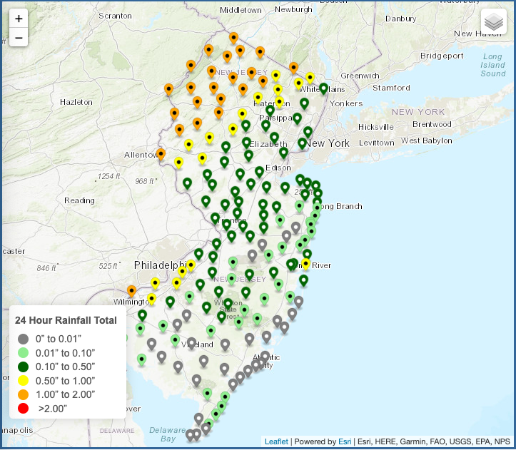
- North Jersey is under a flash flood warning. The warning for Bergen, Essex, Hudson, Passaic and Union Counties runs until 7:45 p.m. Wednesday. The warning in Morris, Somerset, Hunterdon, Sussex and Warren Counties lasts until 12:15 a.m. Thursday. Doppler has indicated 1 to 3 inches of rain have fallen in North Jersey, with flash flooding ongoing or expected to begin shortly as of 6:10 p.m.
- Northwest New Jersey has been hit worst by the storm as of 6 p.m., with 1 to 2 inches of rain hitting the region as the storm continues to push through.
- Trees are starting to come down as of 5:45 p.m. Officials closed the right lane on Route 31 northbound (south of Route 624/Belvidere Avenue) in Oxford Township, Warren County.
- As many commuters make their way home through stormy weather, traffic officials are reporting congestion on major roads and highways. A crash occurred at about 5 p.m. Wednesday on Route 616 westbound in Perth Amboy, closing all lanes.
- The National Weather Service issued a flood warning for several New Jersey rivers: Passaic River at Chatham, Pine Brook, and Little Falls and above Singac; Pequannock River below Macopin Dam; South Branch Raritan River at Stanton; North Branch Raritan River at Raritan; Raritan River at Manville and Bound Brook.
- The City of Hoboken announced a link to a new online beta flood mapping tool for residents to enter and get current information. The city also said street sweeping is suspended Thursday. Read more: New Hoboken Flood Mapping Tool Available As Storm Ida Nears: City
- In Wayne, officials urged residents of flood-prone areas to make evacuation preparations. Read more: Wayne Officials To Residents: Make Evacuation Plans Now
- A line of severe thunderstorms moved into Delmarva at about 3:30 p.m., bringing the storm close to New Jersey. Officials reported gusts above 50 mph on the eastern shores of Chesapeake Bay with these storms.
- Parsippany, the largest town in Morris County, is warning that "dangerous and damaging" flooding could occur between 5 p.m. and 8 p.m. Wednesday night.
- Middlesex Borough, which experienced flooding in the last major storm, is already warning residents to be prepared to evacuate their homes Wednesday night.
- The National Weather Service of Philadelphia/Mount Holly issued a tornado watch for 15 New Jersey counties: Atlantic, Burlington, Camden, Cape May, Cumberland, Gloucester, Hunterdon, Mercer, Middlesex, Monmouth, Morris, Ocean, Salem, Somerset and Warren. The tornado watch will last until 10 p.m. Wednesday. The agency's New York office, which covers New Jersey's northeast counties, has not issued a tornado watch as of 1:15 p.m. Wednesday. Read more: What To Do When You Get Tornado Watch, Warning Alerts In NJ
- Gov. Phil Murphy warned that many communities are still waterlogged from last week's storms, heightening the risk of flash flooding. "If you are out and come across high waters, do not go into them," Murphy said. "Turn around, don't drown."
- Some towns anticipate getting some of the worst flooding they've had in years, with torrential storming producing several inches of rain in a short period of time. "This will likely be one of the worst flooding events we've had over the last decade," said the Township of Parsippany. "We expect widespread roadway flooding along with life-threatening flash flooding that will rapidly develop this evening as nearly all streams in the area overflow their banks by a significant amount."
Original Report
NORTH JERSEY — Flooding, thunderstorms and possibly tornadoes: forecasters say North Jersey could see all of the following as the remnants of Ida move through the region Wednesday to Thursday.
Find out what's happening in Morristownfor free with the latest updates from Patch.
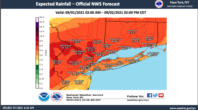
The National Weather Service predicted 3 to 6 inches of rain in North Jersey, with West Milford most affected at 6.24 inches. Forecasts for the Paramus area call for 5.73 inches of rain, while the agency expects Morristown to get 5.81 inches.
Tornadoes are more likely to develop in South Jersey on Wednesday afternoon or evening, according to the National Weather Service.
Find out what's happening in Morristownfor free with the latest updates from Patch.
Numerous instances of flash flooding are "likely" through predawn Thursday, especially since the ground remains saturated from previous heavy storms, according to the National Weather Service. If rainfall predictions hold accurate, flooding is likely along susceptible rivers, creeks and streams.
The National Weather Service issued a flash flood watch for Hunterdon, Mercer, Middlesex, Morris, Somerset, Sussex and Warren Counties that lasts until 8 a.m. Thursday. A flood watch for Passaic, Bergen, Essex, Union and Hudson Counties is set to last until 2 p.m. Thursday.
What has changed in the forecast since Tuesday?
The National Weather Service now predicts an "enhanced risk" for tornadoes extending north. The main threats from any developing thunderstorms will be tornadoes and damaging wind gusts. These would most likely take place Wednesday afternoon and evening.
Tornados are most likely to take place in South Jersey, according to the National Weather Service.
How to Prepare
The National Oceanic and Atmospheric Administration encourages people in Atlantic states to download the FEMA mobile app. Find tips for hurricane preparedness at ready.gov.
Atlantic hurricane season lasts from June 1 to Nov. 30. There is a 60 percent chance of an above-normal hurricane season this year, according to the NOAA.
Get more local news delivered straight to your inbox. Sign up for free Patch newsletters and alerts.