Weather
3 Essex County Rivers Not At Flood Stages – Yet (Winter Storm Update)
Here's where things stand at river checkpoints in Newark, Bloomfield and Verona.


ESSEX COUNTY, NJ — Three rivers in Essex County were all below their “flood stages” on Tuesday afternoon. But weather forecasters continue to warn of a major winter storm coming to New Jersey, which could turn the tide – literally.
Gov. Phil Murphy has declared a state of emergency in the Garden State ahead of a winter storm system set to bring up to four inches of rain, flooding and wind gusts up to 65 mph. It goes into effect across New Jersey at 5 p.m. on Tuesday.
The National Weather Service has issued a new map saying river flooding is likely in much of North Jersey. Read More: River Flooding 'Likely' Tuesday To Wednesday In Essex County
Find out what's happening in Newarkfor free with the latest updates from Patch.
Officials in multiple Essex County towns have warned about high water levels at local rivers and streams, including Bloomfield and Montclair.
Just north of Essex County, the Passaic River in Little Falls is expected to begin rising above the flood stage of 7 feet on Wednesday afternoon, eventually hitting 9.4 feet on Friday morning, according to the NWS Advanced Hydrologic Prediction Service. Read More: These NJ Rivers Expected To Have Major Flooding As Storm Arrives
Find out what's happening in Newarkfor free with the latest updates from Patch.
Here’s where things stood at three key waterways in Essex County as of Tuesday afternoon. NOTE: Flood forecasts are not available for the following points.
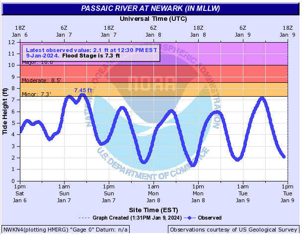
PASSAIC RIVER IN NEWARK
The flood stage of the Passaic River at Newark is 7.3 feet. The river was at 2.1 feet as of 12:30 p.m. on Tuesday. However, it was measured at 7.13 feet at 6:18 a.m., which neared the flood stage.
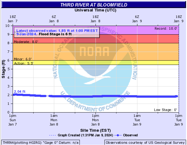
THIRD RIVER IN BLOOMFIELD
The flood stage of the Third River at Bloomfield is 6 feet. The river was at 1.85 feet as of 1 p.m. on Tuesday.
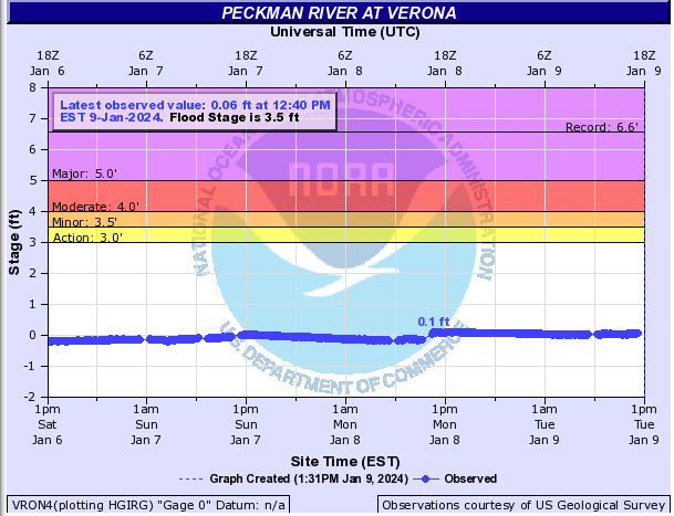
PECKMAN RIVER IN VERONA
The flood stage of the Peckman River at Verona is 3.5 feet. The river was at 0.06 feet as of 12:40 p.m. on Tuesday.
Each of the above rivers have seen flooding during severe storms in the past.
The Passaic River winds across nearly 80 miles of North Jersey, flowing through several counties until it joins the Hackensack River at the northern end of Newark Bay. Along the way, it passes by Essex County municipalities including Belleville, Nutley and Newark, with several other towns located within its watershed. See Related: NJ Officials Tour Flood Sites Along Third River In Belleville
The Third River – also known as the Yantacaw River – passes through several Essex County towns including Montclair, Bloomfield and Nutley, eventually entering the Passaic River near the border of Nutley and Clifton.
The Peckman River starts in West Orange and flows northeast through the townships of Verona, Cedar Grove and Little Falls until it meets the Passaic River in Woodland Park.
After Hurricane Ida hit in 2021, the three rivers swelled, adding another layer of anxiety for the residents and business owners already struggling with devastating flood damage. See Related: In Ida's Wake: Drone Captures Videos Of 2 Rivers In Essex County
The following drone footage captured by Francis Gibbons shows the Passaic River near River Road in Nutley and Riverside County Park in Lyndhurst on Sept. 4, 2021.
The below footage shows the Third River as seen on Sept. 4, 2021 in Nutley and Montclair.
Send local news tips and correction requests to eric.kiefer@patch.com. Learn more about advertising on Patch here. Find out how to post announcements or events to your local Patch site.
Get more local news delivered straight to your inbox. Sign up for free Patch newsletters and alerts.