Weather
NJ Weather On Easter: 'Widespread Accumulating Snow' In Forecast
No, it's not an April Fool's joke. Here's what to expect.


No, no, this is not an April Fool's joke. We're just the messenger. The meteorologists at the National Weather Service are saying it, too. So take it for what it's worth.
Despite what you may believe, winter isn't quite over yet. "Accumulating snow" is supposed to hit just when your relatives are getting in their cars to drive home on Easter. An inch per hour could even fall at some point.
A winter weather advisory is in effect in most of New Jersey. Read more: NJ Weather On Easter: Winter Weather Advisory, Snow Estimates
Find out what's happening in Point Pleasantfor free with the latest updates from Patch.
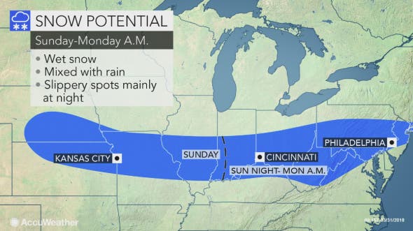
The NWS says "widespread accumulating snow" late Sunday night through Monday morning could result in sloppy, hazardous travel for the Monday morning commute.
"So, apparently, the groundhog is going into extra innings with the winter forecast. Assuming we can even play baseball in the snow," said Gary Szatkowski, a former meteorologist with the National Weather Service.
Find out what's happening in Point Pleasantfor free with the latest updates from Patch.

This storm will be a quick-hitting system with most of the accumulation occurring during a 3- to 4-hour window between 3 and 10 a.m., depending on the location, according to the NWS.
The highest probability for several inches of accumulation looks to be north and west of Philadelphia, especially in the higher elevations.
Snowfall rates and temperatures could play a huge role. A narrow band of heavy snow sets up somewhere over the area early Monday morning. Snowfall rates – 1 inch per hour – in this band would potentially be heavy enough to overcome the warm ground and allow for snow to start accumulating on roads, according to the NWS.
The snow could be enough to cause schools to delay openings and – gasp – even close school on Monday. Many – if not most – school districts are on spring break this week, though some had to add school time to make up for snow days. Read more: New Jersey School Closings/Delays List For 4/2/18
The band of accumulating snow may be no more than 100 miles wide, so a 50-mile shift in the storm track could mean the difference between several inches of snow, rain or dry weather, according to AccuWeather.
Although snow will stick to grassy surfaces along the entire swath, the majority of snow that falls during the daylight hours will melt on paved and concrete surfaces because of the April sun angle, according to AccuWeather.
"While accumulating snow is typically hard to come by in the springtime as temperatures inch upwards, any snow falling overnight will have an easier time sticking to roads and sidewalks," according to AccuWeather Meteorologist Faith Eherts.
"However, roads and sidewalks can still become slushy and slick for a time during the day where the snow falls heavily and can overcome the effect of the strong sun," AccuWeather Senior Meteorologist Kristina Pydynowski said.
Slippery travel and snow-covered roadways will again become an issue from the Ohio Valley to New Jersey, where most of the snow should fall on Sunday night, according to AccuWeather. Motorists will not be the only ones impacted.
"Flights in and out of Indianapolis; Washington, D.C.; Baltimore; and Pittsburgh, Harrisburg, Allentown and Philadelphia, Pennsylvania, could face delays and cancellations Sunday evening through Monday morning," Eherts said.
Higher traffic volume is expected this Easter weekend, so those in the path of the storm should allot extra time to get to their destinations and be prepared for adverse, rapidly changing weather conditions, according to AccuWeather.
“The Monday morning commute could be filled with delays, especially along the Interstate-95 corridor from Baltimore through Philadelphia and possibly as far north as New York City,” Eherts added.
A low pressure system is developing along a cold front, bringing some early April snow to the region, according to the NWS.
Here is the forecast:
- Sunday: Partly sunny, with a high near 61. West wind 9 to 14 mph.
- Sunday night: A slight chance of rain and snow between 9pm and midnight, then snow likely. Mostly cloudy, with a low around 32. West wind around 6 mph becoming light and variable. Chance of precipitation is 60%. New snow accumulation of less than one inch possible.
- Monday: Rain and snow before noon, then a chance of rain between noon and 2pm. High near 46. Northeast wind 5 to 7 mph becoming northwest in the afternoon. Chance of precipitation is 80%. New snow accumulation possible.
- Monday night: A chance of rain after 2am. Partly cloudy, with a low around 33. Southwest wind around 5 mph becoming calm in the evening. Chance of precipitation is 30%.
- Tuesday: Rain likely, mainly after 8am. Cloudy, with a high near 50. Chance of precipitation is 70%. New precipitation amounts between a tenth and quarter of an inch possible.
- Tuesday night: A chance of rain. Mostly cloudy, with a low around 47. Chance of precipitation is 50%.
- Wednesday: Showers likely, mainly after 8am. Cloudy, with a high near 62. Chance of precipitation is 60%.
Shutterstock photo
Get more local news delivered straight to your inbox. Sign up for free Patch newsletters and alerts.