Weather
NJ Weather: Winter Storm Warning Expands As Murphy Addresses Snow
WATCH: Gov. Phil Murphy addressed warnings that have expanded again for a winter snowstorm that's expected to hit NJ.


NEW JERSEY – The National Weather Service issued a winter storm warning this weekend for five New Jersey counties and other alerts expanded as expected snow accumulation totals have risen for the weather system on Sunday, Monday and Tuesday. Gov. Phil Murphy addressed the storm preparations on Sunday, and Patch has the press conference (see below).
Parts of New Jersey could get nearly a foot, and those predicated snow totals have grown since Saturday morning (see expected snow totals below).
Find out what's happening in Point Pleasantfor free with the latest updates from Patch.
Enough snow – 5 to 9 inches in spots – could fall to close schools or delay openings. Read more: New Jersey School Closings/Delays List For Monday and Tuesday.
Instead of flying to California as he planned, Murphy said he will remain in New Jersey this weekend and discuss the weather preparation operations. Here is his press conference:
Find out what's happening in Point Pleasantfor free with the latest updates from Patch.
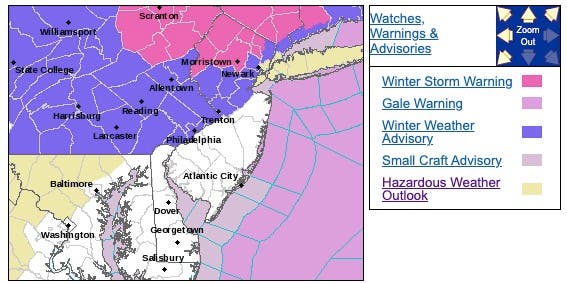
A winter storm warning was issued for Bergen, Passaic, Sussex, Morris and Warren counties. The warning was set to begin at 4 a.m. on Sunday and end between 1 and 7 a.m. on Tuesday.
A winter weather advisory, which will expire at 1 a.m. on Tuesday, was also issued for Middlesex, Somerset, Mercer and Hunterdon counties.
The rest of the state is expected to get rain. Here are the alerted areas:
The storm could wreak enough havoc to make holiday travel a complete mess. Here is what you should expect:
- A light wintry mix may develop on Sunday morning along and west and north of the I-95 corridor and it may result in some slippery travel. However, the mix could quickly change to rain.
- A lull in precipitation is possible on Sunday afternoon and evening. Then, much of the snow that is forecast is then expected to occur later Sunday night and Monday.
- Rain or a wintry mix should change to snow Sunday night along and north of the I-78 corridor. Significant snowfall amounts are possible for the I-80 corridor northward.
- Total snow accumulations of 5 to 9 inches – a slight tick downward from the original prediction of 5 to 11 inches – and ice accumulations of up to one-tenth of an inch are possible.
- The bulk of the snow in North Jersey is expected to fall between 8 a.m. and 6 p.m. on Monday.
- Rain is also expected to change to snow on Monday afternoon in South Jersey and the Jersey Shore.
- Untreated surfaces may become hazardous, with the most travel impacts along and north of I-78
- Travel could be very difficult throughout this period. The hazardous conditions could impact holiday return travel on Sunday and the commute periods on Monday.
Here are the expected snow totals, which have grown since Saturday morning:
.png)
.png)
Here is the high-end prediction:
.png)
.png)
Here is the estimated ice accumulation:


The troublesome combination of heavy rain, ice, snow and strong winds will hamper travelers making their way home from their Thanksgiving destinations this weekend, since the major storm will add to travel stress on the roads and at the airports, according to AccuWeather.
Forecasters are calling it a double-barreled storm that will first spread rain, ice and snow into the northeastern United States during Saturday and Sunday, according to AccuWeather.
Rain will expand to the lower mid-Atlantic coast during Saturday afternoon and night, including the South Jersey, Baltimore, Philadelphia, Washington, D.C. and Richmond, Va. areas.
During Sunday, a second storm center is forecast to develop along the mid-Atlantic coast. Eventually, this coastal storm will take center stage, according to AccuWeather.
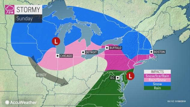
The rain will reach northward along the Delaware and New Jersey coasts. However, around the New York City area and the southern New England coast, conditions in the atmosphere may be such to allow a mixture of rain and sleet to occur at the onset, according to AccuWeather.
The area of ice is forecast to broaden over the Northeast as cold air holds its ground and the atmosphere begins to moisten up, according to AccuWeather.
However, it is the tail end of the storm that may bring a foot of snow to part of the region from Sunday night to Monday, according to AccuWeather.
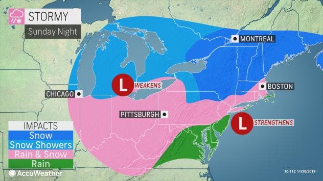
It is during Sunday night to Monday when the effects of the strengthening coastal storm are likely to be realized, according to AccuWeather.
As the coastal storm ramps up, a slight drop in temperature and enhanced moisture from the Atlantic will cause a change to snow or a wintry mix to extend farther south in the mid-Atlantic and snowfall rates to increase, according to AccuWeather.
Those with flights into or out of the region on Sunday and Monday, especially from Philadelphia, Newark, New York City and Boston, should expect delays and be prepared for flight cancellations, according to AccuWeather

Here's the forecast:
- Sunday: Snow and sleet in some areas likely before 11am, then rain and sleet between 11am and 2pm, then rain after 2pm. High near 41. East wind 7 to 11 mph. Chance of precipitation is 100%. New snow and sleet accumulation of less than a half inch possible.
- Sunday night: Snow or rain. Low around 35. Northeast wind 11 to 15 mph. Chance of precipitation is 100%. New precipitation amounts between a quarter and half of an inch possible.
- Monday: Snow or rain before 8am, then snow, rain or sleet between 8am and 11am, then snow after 11am. High near 37. North wind 9 to 11 mph. Chance of precipitation is 90%. New snow and sleet accumulation of 1 to 3 inches possible.
- Monday night: Snow before 11pm, then snow showers likely, mainly between 11pm and 2am. Low around 26. Chance of precipitation is 80%.
- Tuesday: A chance of snow showers before 8am. Partly sunny, with a high near 41. Chance of precipitation is 30%.
Get more local news delivered straight to your inbox. Sign up for free Patch newsletters and alerts.