Weather
Severe Thunderstorm Warning In 3 NJ Counties, 60-MPH Winds
UPDATE: Severe weather was still expected to pass through NJ. Damaging winds, "severe hail" and even an isolated tornado are possible.


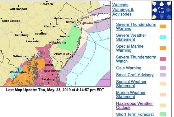
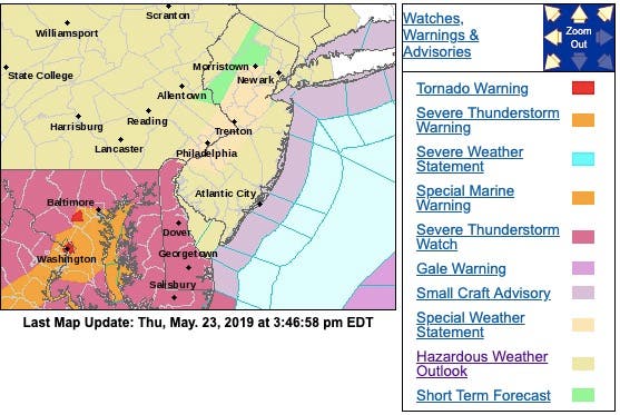
A severe thunderstorm warning was issued for three New Jersey counties as bad weather was still expected on Thursday night and Friday morning, according to the Natonal Weather Service.
A severe thunderstorm was located over the region, moving southeast at 45 mph. The storm had 60-mph wind gusts and quarter-size hail.
Minor damage to vehicles was possible. Wind damage to roofs, siding, trees and power lines was possible. The warning was in effect in Camden, Gloucester and Salem counties.
Find out what's happening in Point Pleasantfor free with the latest updates from Patch.
Here were the alerted areas:

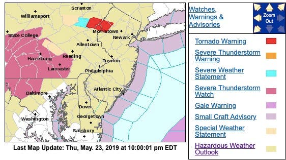
A tornado warning was also issued for two New Jersey counties as storms continued to threaten the state on Thursday night. The warning expired at 10:30 p.m.
Find out what's happening in Point Pleasantfor free with the latest updates from Patch.
The warning was issued for Sussex and Warren counties as a tornado and quarter-size hail were possible, according to the National Weather Service.
Flying debris will be dangerous to those caught without shelter. Mobile homes could be damaged or destroyed. Damage to roofs, windows, and vehicles could occur. Tree damage is likely, according to the National Weather Service.
Here were the alerted areas:
Damaging 60-mph winds, thunderstorms, power outages and "severe hail" were still possible possible as severe weather began to hit New Jersey on Thursday. There were also accidents on highways (see list below).
The National Weather Service has issued a hazardous weather outlook for the entire state, saying an isolated tornado anywhere in the state is also still possible. Storms were expected to hit during the afternoon, and then more could return before 2 a.m.
During the afternoon, the NWS issued a special weather statement, saying strong thunderstorms were moving along a line extending into North and Central Jersey, and then heading to the Jersey Shore. Wind gusts up to 40 mph and pea-size hail were possible with these storms.
Torrential rainfall was also occurring with these storms and was expected to cause localized flooding. These storms may intensify, so be certain to monitor local radio stations and available television stations for additional information and possible warnings from the National Weather Service.
Here are the alerted areas – the storm was expected to pass over the Jersey Shore:
It hit Central Jersey earlier:
Here were the alerted areas in North Jersey earlier:

New Jersey already had some thunderstorms on Thursday morning, and rain was expected to continue through the day. More than 1,500 people were without power in Edison, Woodbridge and Toms River early Thursday.
But the bulk of the worst storms could hit just when people are going to sleep, or starting their Memorial Day weekend vacation (story continues below photo):

Here is what to expect:
- Thunderstorms, some of them severe, will impact the area this evening.
- There could be two rounds of storms overall. The first was in the mid to late afternoon, and a second round is expected during the evening.
- Any severe storms will be capable of producing damaging wind gusts, leading to scattered downed trees and power outages. A few storms may also produce large hail.
- An isolated tornado is also possible. While damaging straight-line winds will be a more widespread concern, should any tornadoes form, localized damage would occur.
- Flooding is not expected to be a widespread concern. However, any thunderstorms may produce brief heavy rainfall, and localized flash flooding is possible especially in urban areas.
- Today is likely to be a busy travel day due to the upcoming holiday weekend. The highest storm threat will occur during and after the evening rush hour. Those traveling should be aware of this risk (story continues below photo).

Here were the accidents in the area on Thursday afternoon:
- New Jersey Turnpike : New Jersey Turnpike southbound South of Interchange 6 - Pennsylvania Turnpike in Mansfield Twp. Center lanes blocked.
- NJ 29: Earlier Incident and electrical repairs on NJ 29 in both directions ramp to/from Abernethy Dr in Trenton. Ramp closed and detoured until 8:30 P.M.
- I-280: Delays and an arlier Incident on I-280 westbound between West of CR 508 in Kearny and Exit 14W - Clifton Av in Newark 10-15 minute delay.
- Garden State Parkway : Accident on the Garden State Parkway northbound South of Exit 153A - NJ 3 in Clifton. 2 right lanes blocked.
- I-295: Accident on I-295 northbound South of Exit 17 - CR 680/Harmony Rd in Greenwich Twp. Right shoulder closed use caution.
- Garden State Parkway: Accident on the Garden State Parkway northbound approaching Union Toll Plaza in Hillside Twp. 1 toll lane blocked.
- New Jersey Turnpike : Disabled vehicle on the New Jersey Turnpike inside exit Interchange 11 - Garden State Parkway in Woodbridge Twp. Right shoulder blocked.
Isolated tornadoes were among the dangers as a surge of heat and humidity helps to fuel severe thunderstorms in the northeastern United States on Thursday, according to AccuWeather.
Severe thunderstorms will continue to track from eastern Ohio into western parts of New York and Pennsylvania before spreading over New Jersey and the rest of New York state and the mid-Atlantic into Thursday evening, according to AccuWeather.
"Some of these storms may produce flooding in low-lying and poor drainage areas," AccuWeather Meteorologist Alyson Hoegg said in a release.
AccuWeather meteorologists say they are also concerned that the storms can produce hail and damaging winds. Trees with a weakened root structure from recent rainfall will be more susceptible to being downed by thunderstorm winds, even if gusts are below 58 mph. "There can also be an isolated tornado," Hoegg said.
The storms may lead to times of reduced visibility along sections of interstates 70, 79, 80, 81, 83, 90 and 95 at a time when many people may be getting a jump start on holiday travel, according to AccuWeather. "Everyone starting their holiday weekend early should keep an eye to the sky as these storms could lead to slower travel and delays at airports," Hoegg said (story continues below photo).
.jpeg)
- Thursday night: Showers and thunderstorms likely, mainly before 9pm. Some storms could be severe, with large hail and damaging winds. Mostly cloudy, then gradually becoming mostly clear, with a low around 60. Southwest wind 6 to 8 mph. Chance of precipitation is 60%. New rainfall amounts between a tenth and quarter of an inch, except higher amounts possible in thunderstorms.
- Friday: Sunny, with a high near 78. Northwest wind around 14 mph, with gusts as high as 26 mph.
- Friday night: Partly cloudy, with a low around 54. North wind 5 to 10 mph becoming light after midnight.
- Saturday: Mostly sunny, with a high near 78. South wind 3 to 8 mph.
- Saturday night: A chance of showers and thunderstorms. Mostly cloudy, with a low around 60. Chance of precipitation is 40%.
- Sunday: Mostly sunny, with a high near 87.
Get more local news delivered straight to your inbox. Sign up for free Patch newsletters and alerts.