Weather
Snow Estimates For Next Storm As Winter Weather Hits NJ
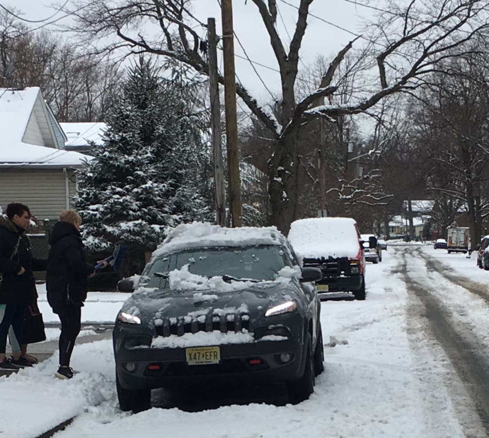
New Jersey was dealing with crashes and speed restrictions on Saturday as a snowstorm hit harder than expected.


UPDATED: Winter Storm Warning In 18 NJ Counties: Here's What To Expect
ORIGINAL STORY: Another storm is on its way to New Jersey this weekend after a Saturday snowfall hit harder than expected, leaving 5 inches in spots
Snow estimates were also released for what could be the worst system of the season, and it's expected to arrive after 1 p.m. Sunday. Read more: New Jersey Snow Totals And Estimates, Town-By-Town, For Saturday Through Monday
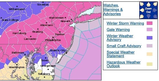
A winter storm warning was declared for 18 New Jersey counties for the Sunday system, with the National Weather Service saying heavy snow is possible. Only Atlantic, Cape May and Cumberland counties were spared from the watch, getting a winter weather advisory. Total snow accumulations of 4 to 9 inches could happen.
Find out what's happening in Point Pleasantfor free with the latest updates from Patch.
A hazardous weather outlook was issued for the state, too. Schools could be impacted on Monday. Read more: New Jersey School Closings/Delays List For Monday
Here are the alerted areas:
Find out what's happening in Point Pleasantfor free with the latest updates from Patch.
Here is what is expected for the Sunday-Monday system, from the NJ Office of Emergency Management:
- Northwestern NJ snow is forecast to start around 1 p.m. Sunday, ending by 6 a.m. to 7 a.m. Monday. Rain may fall in some locations between 1 p.m. and 6 p.m. Sunday.
- Northeastern NJ snow is forecast to start around 6 p.m. Sunday, ending by 6 a.m. Monday. Rain is forecast between 1 p.m. and 6 p.m. Sunday.
- Central NJ snow is forecast to start around 1 p.m. Sunday, ending by 6 a.m. Monday for inland counties.
- Snow is forecast to start around 7 p.m. to 9 p.m. Sunday, then again from 1 a.m. to 6 a.m. Sunday, for coastal counties. Rain is forecast between 1 p.m. Sunday and 6 a.m. Monday.
- Southwestern NJ snow is forecast to start around 7 p.m. Sunday, ending by 6 a.m. Monday. Rain is forecast between 1 p.m. Sunday and 3 a.m. Monday.
- Southeastern NJ snow is forecast to start around 4 a.m. Monday, ending by 6 a.m. Monday. Rain is forecast from 1 p.m. Sunday to 6 a.m. Monday.
- Snow will mix with sleet at times for most locations statewide. The current forecast as of Saturday is: northwestern NJ: 5" to 10" of snow and sleet; northeastern NJ: 4" to 8" of snow and sleet; inland central: 2" to 5" of snow and sleet; coastal central: 1" to 3" of snow and sleet, possibly up to 1" of rain; southwestern NJ: 1" to 3" of snow and sleet, possibly up to 1" of rain southeastern NJ: 0" to 1", about 1" of rain
- There is potential for some minor spotty flooding associated with the Monday morning high tide along the southeast coast. In southern counties, if more rain than snow falls, there could be localized ponding and minor flooding, including small creeks and streams, low-lying places, roadways, and areas with poor drainage.
- The actual storm track will determine precipitation types and amounts as well as the location of the rain/snow line. We could see snow totals increase or decrease in the forecast by Sunday morning, but we do anticipate accumulations over 5" in northern counties, especially northwestern NJ.
- If forecast totals include amounts 6" or above for northern counties, we should see the winter storm watch change to a winter storm warning by Sunday morning. We may see an advisory posted for at least southeastern coastal waters, if not the Atlantic coast and Delaware Bay, for minor coastal flooding, small craft advisory, and/or a gale warning, depending on the actual track of the storm and coastal wind forecasts.
Here are the snow estimates for Sunday:
-1551563721-8887.jpg)
-1551563734-2006.jpg)
High-end predictions:
-1551563749-4374.jpg)
-1551563865-8607.jpg)
During the Saturday storm, two airplanes clipped wings at Newark Liberty International Airport Saturday morning, according to officials. It's not known if the incident had anything to do with the weather, but officials did say visibility was poor. Read more: Two Planes Clip Each Other At Newark Airport: Officials
Here were the road conditions at 10:30 a.m. on Saturday:
- New Jersey Turnpike: Speed restriction on the New Jersey Turnpike in both directions from Southern Mixing Bowl in Newark to George Washington Bridge in Fort Lee 45 miles per hour, due to roadway conditions and salting activity.
- NJ 17 : Icing on NJ 17 southbound ramp to Allendale Av in Saddle River. Ramp closed.
- Garden State Parkway: Speed restriction on the Garden State Parkway in both directions from North of Exit 105 - NJ 36 in Tinton Falls to New York State Line in Montvale Plowing and salting operations being conducted. 35 mph. VMS in use.
- Betsy Ross Bridge: Speed restriction on the Betsy Ross Bridge in both directions between New Jersey Side in Pennsauken Twp and Pennsylvania Side in Philadelphia 45 miles per hour due to roadway conditions.
- Commodore Barry Bridge: Speed restriction on the Commodore Barry Bridge in both directions between New Jersey Side and Pennsylvania Side in Logan Twp 45 miles per hour due to roadway conditions.
- Walt Whitman Bridge: Speed restriction on the Walt Whitman Bridge in both directions between New Jersey Side in Gloucester City and Pennsylvania Side in Philadelphia 45 miles per hour due to roadway conditions.
- Atlantic City Expressway: Accident with injuries on the Atlantic City Expressway westbound at East of Exit 5 - US 9 in Pleasantville. Left and center lanes closed MOVE OVER FOR EMERGENCY WORKERS.
- New Jersey Turnpike: Overturned tractor trailer on the New Jersey Turnpike inner and outer roadways northbound South of Interchange 8A - NJ 32 in Monroe Twp.
- US 206: Utility pole down on US 206 southbound North of CR 541/Stokes Rd in Shamong Twp. Right shoulder closed use caution.
- Garden State Parkway: Downed pole on the Garden State Parkway southbound South of Exit 137 - NJ 28 in Cranford Twp. Right lane blocked.
- Outerbridge Crossing: Speed restriction on the Outerbridge Crossing in both directions 30 miles per hour due to roadway conditions.
- Goethals Bridge: Speed restriction on the Goethals Bridge in both directions 30 miles per hour due to roadway conditions.
Get more local news delivered straight to your inbox. Sign up for free Patch newsletters and alerts.


