Weather
Severe Thunderstorms Possible In NJ As Massive Temperature Shift Expected
A high near 72 degrees could approach record territory before powerful storms bring wind gusts, forecaster said.

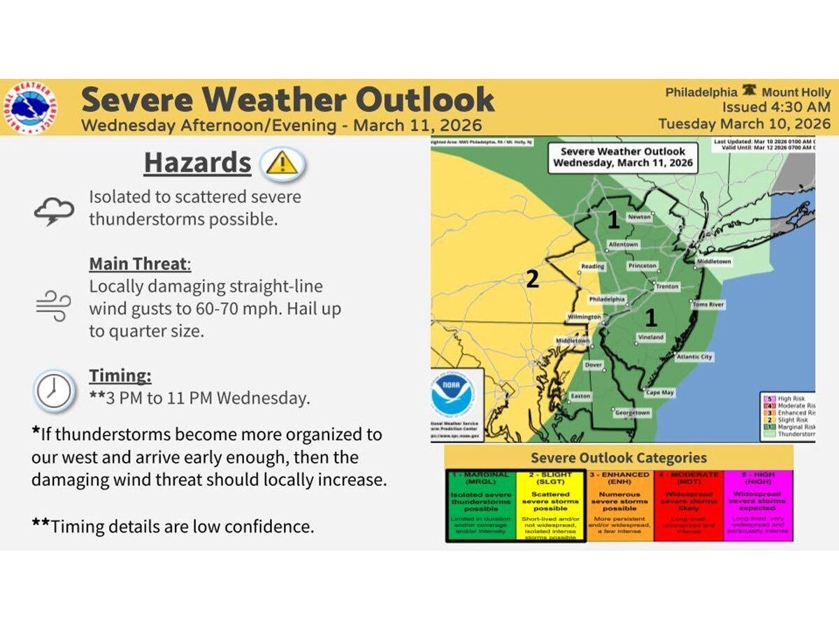
Severe thunderstorms could roll through New Jersey on Wednesday afternoon and evening, forecasters said, bringing dangerous wind gusts to parts of the state.
The National Weather Service said storms are possible between 3 p.m. and 11 p.m. Wednesday, though the exact timing is uncertain.
“A strong cold front approaches Wednesday,” the NWS said Tuesday morning. "Some severe thunderstorms are possible, however this will depend on the timing.”
Find out what's happening in South Brunswickfor free with the latest updates from Patch.
The biggest concerns are wind gusts up to 70 mph that could down trees and power lines, and hail the size of a quarter.
Much of central New Jersey has a slight risk of severe weather. Parts of southern New Jersey have a lower, marginal risk, the NWS said.
Find out what's happening in South Brunswickfor free with the latest updates from Patch.
The storms are expected to fire up ahead of a cold front moving in from the west.
Wednesday will be a warm day first — temperatures could hit 72 degrees, which may approach record territory — before the storms arrive. If the storms get better organized before they reach New Jersey, conditions could get worse, forecaster said.
“High temperatures are forecast to be in the mid to upper 70s for manyplaces, although still much cooler along the coast due to a southerly wind off the cold ocean,” NWS said.
After Wednesday's storms clear, expect a quick cooldown. Rain is likely Wednesday night, with temperatures dropping to around 57.
Thursday stays cloudy and cool, with showers likely in the morning, a high near 61 and wind gusts up to 30 mph.
There is a 70 percent chance of rain on Thursday, with most of it wrapping up by 2 p.m. A stray shower is possible Thursday evening, then temperatures plunge overnight to around 29.
The weekend looks much more pleasant. Friday will be mostly sunny with a high near 49. Saturday brings partial sunshine and a high of around 53.
Here's the forecast for the next few days:
- Wednesday: A slight chance of showers after 2 p.m. Partly sunny, with a high near 74. Light south wind increasing to 5 to 10 mph in the morning. Chance of precipitation is 20 percent.
- Wednesday Night: A chance of showers, mainly after 8 p.m. Mostly cloudy, with a low around 57. South wind 5 to 15 mph. Chance of precipitation is 40 percent. New precipitation amounts of less than a tenth of an inch possible.
- Thursday: Showers likely, mainly before 2 p.m. Cloudy, with a high near 61. Northwest wind around 15 mph, with gusts as high as 30 mph. Chance of precipitation is 70 percent. New precipitation amounts between a tenth and quarter of an inch possible.
- Thursday Night: A chance of showers before 8 p.m. Partly cloudy, with a low around 29. Chance of precipitation is 30 percent. New precipitation amounts of less than a tenth of an inch possible.
- Friday: Mostly sunny, with a high near 49.
- Friday Night: Mostly cloudy, with a low around 38.
Have a correction or a news tip? Email sarah.salvadore@patch.com
Get more local news delivered straight to your inbox. Sign up for free Patch newsletters and alerts.