Crime & Safety
Flash Flooding, Severe Thunderstorms Expected For Union County
The NWS has issued a Hazardous Weather Outlook, saying showers and thunderstorms will likely produce heavy rain, leading to flash flooding.

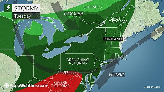
Flash flooding could hit the area Tuesday since severe thunderstorms and strong winds are expected, according to the National Weather Service.
The NWS has issued a Hazardous Weather Outlook, saying showers and thunderstorms will likely produce heavy rain, leading to localized flash flooding.
There is also a slight risk of severe thunderstorms Tuesday night and on Wednesday.
Find out what's happening in Springfieldfor free with the latest updates from Patch.
AccuWeather Senior Meteorologist Dave Dombek said that, while the majority of these storms will not be severe, a few communities could be hit with flooding downpours and strong gusty winds from the upper mid-Atlantic to New York.
Here is the forecast:
Find out what's happening in Springfieldfor free with the latest updates from Patch.
Tuesday: A chance of showers, with thunderstorms also possible after 2pm. Some of the storms could produce heavy rain. Mostly cloudy, with a high near 86. South wind 5 to 7 mph. Chance of precipitation is 50%. New rainfall amounts between a tenth and quarter of an inch, except higher amounts possible in thunderstorms.
Tonight: Showers likely and possibly a thunderstorm before 7pm, then showers and thunderstorms likely after 7pm. Patchy fog after 2am. Otherwise, mostly cloudy, with a low around 71. Light south wind. Chance of precipitation is 60%. New rainfall amounts between a quarter and half of an inch possible.
Wednesday: A chance of showers and thunderstorms. Mostly cloudy, with a high near 84. West wind 3 to 6 mph. Chance of precipitation is 50%. New rainfall amounts between a quarter and half of an inch possible.
Wednesday night: A chance of showers and thunderstorms before 2am. Mostly cloudy, with a low around 63. North wind around 11 mph. Chance of precipitation is 40%. New rainfall amounts between a tenth and quarter of an inch, except higher amounts possible in thunderstorms.
Graphic: AccuWeather
Get more local news delivered straight to your inbox. Sign up for free Patch newsletters and alerts.