Weather
Hurricane Florence Shifts South But NJ Ready For Possible Impacts
One NJ town moved its portable bathrooms; others took precautions as Hurricane Florence, now a powerful Category 4 storm, shifted south.


Hurricane Florence, now a powerful Category 4 storm, has shifted south and local impacts in New Jersey are becoming less likely, forecasters say. But local communities are taking steps anyway in case anything happens that impacts the state.
One community, Belmar, has even moved its portable bathrooms from the beach so they don't wash away in the tide. Communities along the Shore have changed garbage collection schedules and other taken other steps in case they're impacted by the storm.
Read more: Belmar, Other Jersey Shore Towns Take Precautions As Hurricane Florence Nears East Coast
Find out what's happening in Toms Riverfor free with the latest updates from Patch.

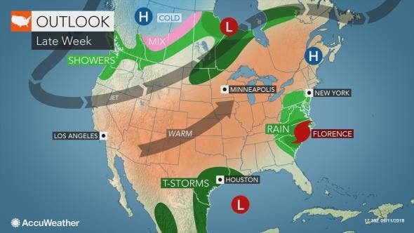
Florence's latest track, which includes making landfall along the Carolina coast later this week, means the chance of prolonged heavy rains in New Jersey as a result of the storm is decreasing.
Still, don't expect it to dry out here. There is plenty of unsettled weather in the forecast through the end of the week, the National Weather Service predicts.
Find out what's happening in Toms Riverfor free with the latest updates from Patch.
You just can't blame all that on Florence.
"None of the rainfall between now and at least Sunday would be attributable to Florence," according to information from the National Weather Service in State College.
In New Jersey, flooding could be the biggest concern since heavy rains across the state have left the ground saturated and unable to handle too much water, Gov Phil Murphy said during a press conference on Tuesday.
Murphy and other officials said New Jersey should expect rising sea levels and strong rip currents that would be life-threatening to swimmers.
Echoing remarks former Gov. Chris Christie made when Hurricane Irene and Superstorm Sandy hit the state in 2011 and 2012, Murphy said: "Please, may I ask you to get off the beach? Pretty please? Use your head."
Read more: Gov. Murphy Updates NJ On Hurricane Florence's Potential Impact
As of early Wednesday, Florence had sustained winds of 130 mph and was moving at a speed of 17 mph, information from the National Hurricane Center said.
Florence is now expected to make landfall as a Category 4 hurricane late Thursday into early Friday and then head due west rather than take a beeline up the coast. Officials are forecasting a high to moderate risk of flash flooding across most of eastern North Carolina, with 15 to 25 inches expected to fall and isolated maximum amounts of 35 inches possible.
It's still uncertain where the storm will go next, but it is possible some moisture from Florence could move north next week. Exactly how much and when is not yet known, forecasters say.
Meanwhile, we can expect the unsettled weather to continue through at least Friday. There is a chance of rain and showers in the forecast each day through then. (Full forecast below)
Here is the forecast:
- Wednesday: A chance of showers and thunderstorms, then showers likely and possibly a thunderstorm after 1pm. Areas of dense fog before 11am. Otherwise, cloudy, with a high near 80. East wind 3 to 5 mph. Chance of precipitation is 60%. New rainfall amounts between a tenth and quarter of an inch, except higher amounts possible in thunderstorms.
- Wednesday night: Showers likely and possibly a thunderstorm before 9pm, then a chance of showers and thunderstorms after 9pm. Patchy fog after 3am. Otherwise, cloudy, with a low around 69. East wind around 6 mph. Chance of precipitation is 60%. New rainfall amounts of less than a tenth of an inch, except higher amounts possible in thunderstorms.
- Thursday: A chance of showers and thunderstorms before 9am, then a chance of drizzle between 9am and 3pm, then a chance of showers and thunderstorms after 3pm. Patchy fog before 3pm. Otherwise, cloudy, with a high near 79. East wind 6 to 8 mph. Chance of precipitation is 40%. New rainfall amounts of less than a tenth of an inch, except higher amounts possible in thunderstorms.
- Thursday Night: A chance of showers and thunderstorms before 3am, then a chance of rain after 3am. Patchy fog after 3am. Otherwise, cloudy, with a low around 69. East wind around 8 mph. Chance of precipitation is 40%. New rainfall amounts of less than a tenth of an inch, except higher amounts possible in thunderstorms.
- Friday: A chance of rain before 9am, then a chance of showers and thunderstorms after 9am. Patchy fog before 9am. Otherwise, cloudy, with a high near 76. East wind around 10 mph. Chance of precipitation is 40%. New rainfall amounts of less than a tenth of an inch, except higher amounts possible in thunderstorms.
- Friday Night: A chance of showers and thunderstorms before 9pm, then a slight chance of showers between 9pm and 3am, then a slight chance of drizzle after 3am. Patchy fog after 3am. Otherwise, mostly cloudy, with a low around 66. Chance of precipitation is 30%. New precipitation amounts of less than a tenth of an inch, except higher amounts possible in thunderstorms.
- Saturday: Patchy fog before noon. Otherwise, partly sunny, with a high near 79.
- Saturday Night: Partly cloudy, with a low around 64.
- Sunday: Mostly sunny, with a high near 81.
With reporting by Kara Seymour
Photo courtesy of NBC4NY of bathrooms being towed away from Belmar boardwalk.
Get more local news delivered straight to your inbox. Sign up for free Patch newsletters and alerts.


