Weather
Major Storm Update: Threats Upgraded In New Jersey
What's being described as a major storm continues to head toward New Jersey, and the potential threats have been upgraded.

What's being described as a major storm continues to head toward New Jersey, and the potential threats - wind and icing, in particular - have been upgraded.
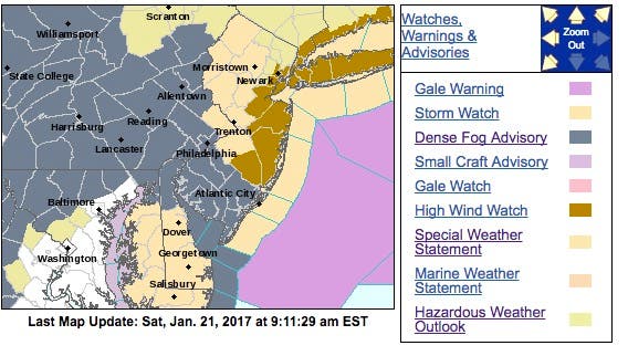
A high wind watch is now effect for eastern New Jersey from late Sunday night to Monday, and the potential for icing has increased. Wind gusts could be as powerful as 60 mph.
The National Weather Service has issued a hazardous weather outlook for the entire state on Sunday and Monday. There should little to no snow, because temperatures will be in the high 30s and 40s.
Find out what's happening in Toms Riverfor free with the latest updates from Patch.
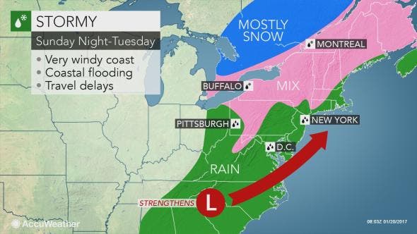
But it won't matter: Heavy rain, windy conditions and coastal flooding are all possible for Sunday afternoon through Monday night.
Here is the latest briefing package from the National Weather Service:
Find out what's happening in Toms Riverfor free with the latest updates from Patch.
- Hazards: Strong Winds – High wind watch for east to northeasterly winds 30-40 mph with gusts to 60 mph near the NJ coast from late Sunday night through Monday afternoon. Winds 20-30 mph with gusts 40-50 mph possible farther inland along the I-95 corridor and in Delaware.
- Heavy Rainfall – Periods of heavy rainfall from Sunday afternoon through early Tuesday, with 1-3 inches across the area. Since the rainfall should be spread out over a 24-36 hour period, the risk of flash flooding and river flooding looks to be low. Some poor drainage flooding can occur in the usual spots.
- Wintry Precipitation – Possibly some freezing rain or a wintry mix in Carbon and Monroe Counties in Pennsylvania and Sussex County in New Jersey Monday and Monday night. While this is less certain, accumulations at this time look to be light and mainly confined to the higher-elevation ridges. Confidence is moderate for a light glaze icing and low for any snow/sleet accumulations.
- Coastal Flooding/Beach Erosion – Minor flooding is probable, especially along the ocean. If the storm is stronger and slower, then moderate coastal flooding would be possible, especially along the ocean and back bays in central NJ. Strong onshore winds and battering waves could cause significant beach erosion.
Read more: Major Storm Expected For New Jersey; Hazardous Weather Outlook Issued
The storm could develop into something that resembles nor'easter, bringing drenching rain and gusty winds as it sweeps eastward from California to Georgia and Florida this weekend, according to a release from AccuWeather, which described the system as a "major storm."
"Enough rain will fall to cause street and poor drainage-area flooding," AccuWeather Senior Meteorologist John Gresiak said in the release.
If the storm develops to its full potential, winds could become strong enough to down trees and cause sporadic power outages, according to AccuWeather.
Patch file photo
Get more local news delivered straight to your inbox. Sign up for free Patch newsletters and alerts.