Weather
Powerful Hurricane Matthew Forms in Atlantic: Could It Impact NJ?
BREAKING: Matthew is the strongest hurricane to form in the Atlantic since 2007.

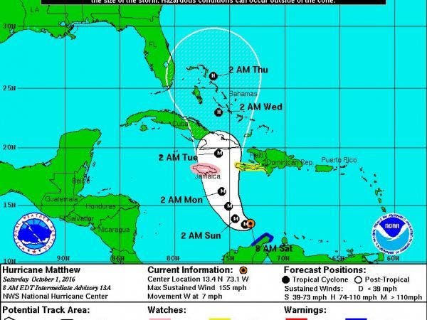
Hurricane Matthew, a Category 4 storm packing sustained winds of 155 mph, is expected to cause significant damage in Jamaica, Cuba and the Bahamas early next week - and it could have a serious impact on New Jersey, forecasters say.
Forecasters are watching the hurricane closely for potential impacts to the east coast of the United States late next week.
Matthew briefly became a Category 5 storm Friday night before weakening slightly by Saturday morning. Matthew is the strongest hurricane to form in the Atlantic since Hurricane Felix in 2007. As of 8 a.m. Saturday, Matthew was located about 365 miles south of Haiti and moving west at 7 mph.
Find out what's happening in Toms Riverfor free with the latest updates from Patch.
As Matthew turns to the north, hurricane conditions will ramp up across Jamaica, Haiti and eastern Cuba on Sunday night into Monday night before eventually spreading into the Bahamas and the Turks and Caicos on Tuesday into Wednesday, according to AccuWeather.
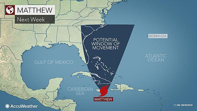
The storm could impact the east coast of Florida by Tuesday or Wednesday, but there is a large amount of uncertainty going into next week, according to a weather.com report. Forecasters will know a lot more about the future track of Matthew after the hurricane completes a northward turn by late Saturday or early Sunday, the report says.
Find out what's happening in Toms Riverfor free with the latest updates from Patch.
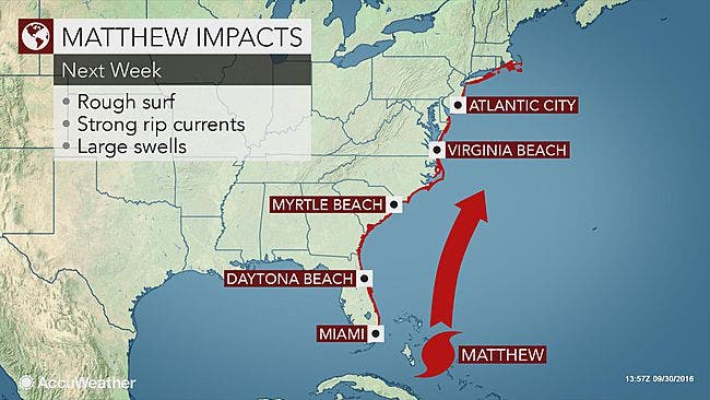
Should Matthew remain offshore of the East Coast, impacts would be minimal for New Jersey and surrounding areas, AccuWeather says, but there would still be a period of rough surf, strong rip currents, beach erosion and dangerous seas that shifts northward.
Latest drop from Hurricane Hunters finding 944 mb pressure w/ #Matthew pic.twitter.com/QKETxSIiFt
— Michael Lowry (@MichaelRLowry) October 1, 2016
Hurricane Matthew’s formation comes at the peak of the 2016 Atlantic hurricane season. Forecasters at the hurricane center say the eight-week period that begins in mid-August and runs through mid-October is a “season within the season.” This eight-week period “is often the most active and dangerous time for tropical cyclone activity,” NOAA explained on its website.
The eight-week period is historically responsible for major spikes in tropical weather activity, NOAA said. In fact, it accounts for about 78 percent of all tropical storm days on record. It is also the period when 87 percent of the category 1 and 2 hurricane days on record occurred. In addition, this period is responsible for “a whopping 96 percent of the major (category 3, 4 and 5) hurricane days.”
Reporting by Tom Davis and Ryan Bonner
Photos: National Hurricane Center, AccuWeather
Get more local news delivered straight to your inbox. Sign up for free Patch newsletters and alerts.


