Weather
'Powerful' Nor'easter Possible For NJ This Week, NWS Says
The National Weather Service has issued an alert for what it described as a "powerful storm" that's expected to hit New Jersey this week.


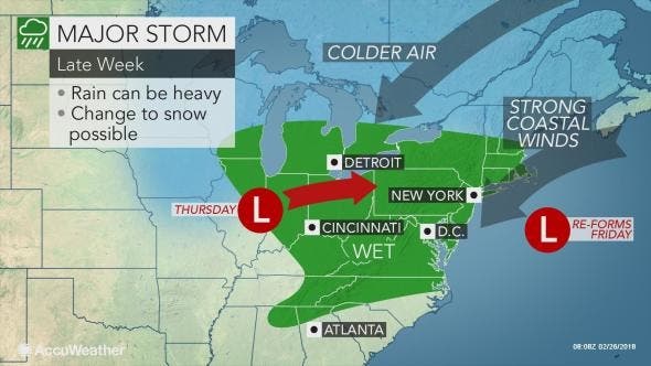
A significant storm that could bring as many as 3 inches of rain and 45-mph winds is expected to hit New Jersey later this week, according to the National Weather Service. The NWS said the storm is expected to be a nor'easter that could create flooding problems throughout the state.
Depending on the track of the storm, some snow is possible – but not probable – in New Jersey. The summer-like storm is supposed to be mainly a rain event since temperatures are expected to climb into the 40s and 50s in most areas of the state, according to Walter Drag, an NWS meteorologist.
Find out what's happening in Toms Riverfor free with the latest updates from Patch.
The storm is expected to arrive Thursday night and last into Friday. "Its impacts here will be significant along the coast," Drag told Patch. "It will be a powerful storm."
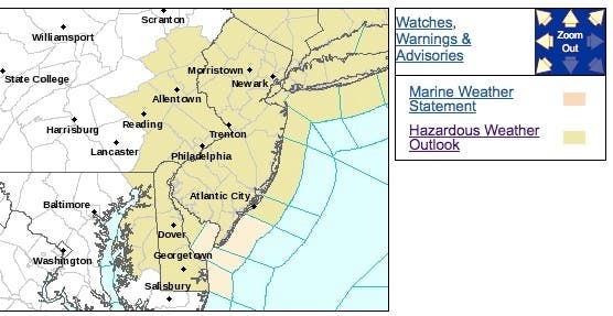
The NWS has issued a hazardous weather outlook for the entire state, saying the rain could cause flooding mostly in northeast and central coastal New Jersey. The heavy rain may result in localized poor drainage flooding, too, and will probably result in significant rises for a few small streams and along the ocean.
Find out what's happening in Toms Riverfor free with the latest updates from Patch.
The system will form over the southern U.S. during the middle of the week, bringing more flooding rain and some severe thunderstorms to already storm weary residents of the Mississippi Valley, according to AccuWeather. The storm will then make its way into the Midwest and Northeast, gathering more strength as it slows down near the coast.
Calm, sunny weather will precede the storm. But the nor'easter could also spell the return of chilly weather to the Midwest and Northeast, according to AccuWeather.
There will be the potential for a narrow swath of strong winds and heavy snow, which could bring near-blizzard conditions through the northern Great Lakes and northern New England. But unless there's a shift in the track, that snow won't be coming to New Jersey, according to AccuWeather.
This potent storm will inch offshore at the end of the week, making it vital for residents along the coast from the Jersey Shore through Maine to prepare for potentially damaging winds blowing in from the ocean, according to AccuWeather.
Here is the forecast:
- Monday: Mostly cloudy, then gradually becoming sunny, with a high near 51. Northwest wind around 10 mph, with gusts as high as 20 mph.
- Monday night: Clear, with a low around 28. Northwest wind around 7 mph.
- Tuesday: Sunny, with a high near 54. West wind 3 to 7 mph.
- Tuesday night: Mostly clear, with a low around 31. Light southwest wind.
- Wednesday: Mostly sunny, with a high near 53. Calm wind becoming southwest 5 to 8 mph in the morning.
- Wednesday night: A chance of rain after 1am. Mostly cloudy, with a low around 40. Chance of precipitation is 30%.
- Thursday: Rain likely. Cloudy, with a high near 49. Chance of precipitation is 70%.
- Thursday night: Rain. Low around 39. Chance of precipitation is 80%.
- Friday: Rain likely. Cloudy, with a high near 43. Chance of precipitation is 70%.
- Friday night: A chance of rain before 1am, then a chance of rain and snow. Mostly cloudy, with a low around 34. Chance of precipitation is 40%.
NJ DE e PA e MD: Fog ltr tngt, possibly dense. Sunshine/mild fcst Mon-Wed aftns. Storm dvlps mid Atlc coast late Thu-Fri and probably results in multiple HIGH tide cycles of some coastal flooding Thu evng-Sun mrng. RfaLL Thu-Fri attached. Purple 1.5"+ #njwx #dewx #pawx #mdwx pic.twitter.com/6EV6SCxdfF
— NWS Mount Holly (@NWS_MountHolly) February 25, 2018
NJ DE e PA e MD: Dry&Mild Tdy-Wed. Storm late Thu-Fri. Still uncertainty! Cstl fldg likely Thu eve-Sun mrng HI tides. Gale/ne swells 10+ft likely later Fri-Sat. Brfg pkg lkly~4P. "chc" few sml stream fldg parts of NJ/PA, chc 2"+ elevation snw. see grphcs. #njwx #dewx #pawx #mdwx pic.twitter.com/Qv44Y0Q35G
— NWS Mount Holly (@NWS_MountHolly) February 26, 2018
Tom Davis photo
Get more local news delivered straight to your inbox. Sign up for free Patch newsletters and alerts.


